File:19630600301NR frN Olbernhau Stegbrücke über die Flöha.jpg
Jump to navigation
Jump to search

Size of this preview: 790 × 599 pixels. Other resolutions: 317 × 240 pixels | 633 × 480 pixels | 1,013 × 768 pixels | 1,280 × 971 pixels | 2,560 × 1,942 pixels | 3,976 × 3,016 pixels.
Original file (3,976 × 3,016 pixels, file size: 3.18 MB, MIME type: image/jpeg)
Captions
Captions
Add a one-line explanation of what this file represents
Summary[edit]
| Description |
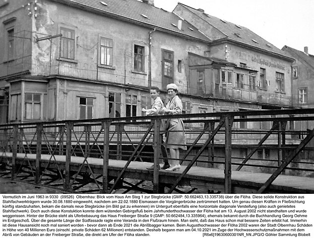
Deutsch: Vermutlich im Juni 1963 in 9330 (09526) Olbernhau: Blick vom Haus Am Steg 1 zur Stegbrücke (GMP: 50.662463,13.335738) über die Flöha. Diese solide Konstruktion aus
Stahlfachwerkträgern wurde 30.08.1880 eingeweiht, nachdem am 22.02.1880 Eismassen die Vorgängerbrücke zertrümmert hatten. Um genau diesen Kräften in Fließrichtung künftig standzuhalten, bekam die damals neue Stegbrücke (im Bild gut zu erkennen) im Untergurt ebenfalls eine horizontale diagonale Versteifung (also auch genietetes Stahlfachwerk). Doch auch diese Konstuktion konnte dem wütenden Gebirgsfluß beim Jahrhunderthochwasser der Flöha hat am 13. August 2002 nicht standhalten und wurde weggerissen. Hinter der Brücke steht als Uferbebauung das Haus Freiberger Straße 9 (GMP: 50.662484,13.335964), ehemals bekannt durch die Buchhandlung Georg Oehme im Erdgeschoß. Über die gesamte Länge der Südfassade ragte eine Veranda in den Flußraum hinein. Man sieht, daß das Haus schon mal bessere Zeiten erlebt hat. Immerhin ist diese Hausansicht noch mal saniert worden - bevor dann ab Ende 2021 die Abrißbagger kamen. Beim Augusthochwasser der Flöha 2002 waren der Stadt Olbernhau Schäden in Höhe von 40 Millionen Euro (einschl. private Schäden 62 Millionen) entstanden. Deshalb begann man am 04.10.2021 im Zuge der Hochwasserschutzmaßnahmen mit dem Abriß von Gebäuden an der Freiberger Straße, die direkt am Ufer der Flöha standen. [R6x6]19630600301NR_frN.JPG/O Göhler Sammlung Blobelt |
||||||||||||||
| Date | |||||||||||||||
| Source | Own work | ||||||||||||||
| Author |
|
||||||||||||||

| Object location | | View this and other nearby images on: OpenStreetMap |
|---|
Licensing[edit]
This file is licensed under the Creative Commons Attribution-Share Alike 4.0 International license.
- You are free:
- to share – to copy, distribute and transmit the work
- to remix – to adapt the work
- Under the following conditions:
- attribution – You must give appropriate credit, provide a link to the license, and indicate if changes were made. You may do so in any reasonable manner, but not in any way that suggests the licensor endorses you or your use.
- share alike – If you remix, transform, or build upon the material, you must distribute your contributions under the same or compatible license as the original.
File history
Click on a date/time to view the file as it appeared at that time.
| Date/Time | Thumbnail | Dimensions | User | Comment | |
|---|---|---|---|---|---|
| current | 12:13, 24 September 2023 | | 3,976 × 3,016 (3.18 MB) | Jörg Blobelt (talk | contribs) | Uploaded a work by {{Creator:Jörg Blobelt}} from {{own}} with UploadWizard |
You cannot overwrite this file.
File usage on Commons
There are no pages that use this file.