File:1943 Japanese World War II Aeronautical Map of Hawaii (text in Japanese) - Geographicus - Hawaii2-wwii-1943.jpg
Original file (5,000 × 3,412 pixels, file size: 5.27 MB, MIME type: image/jpeg)
Captions
Captions
| Hawaii | |||||
|---|---|---|---|---|---|
| Artist | |||||
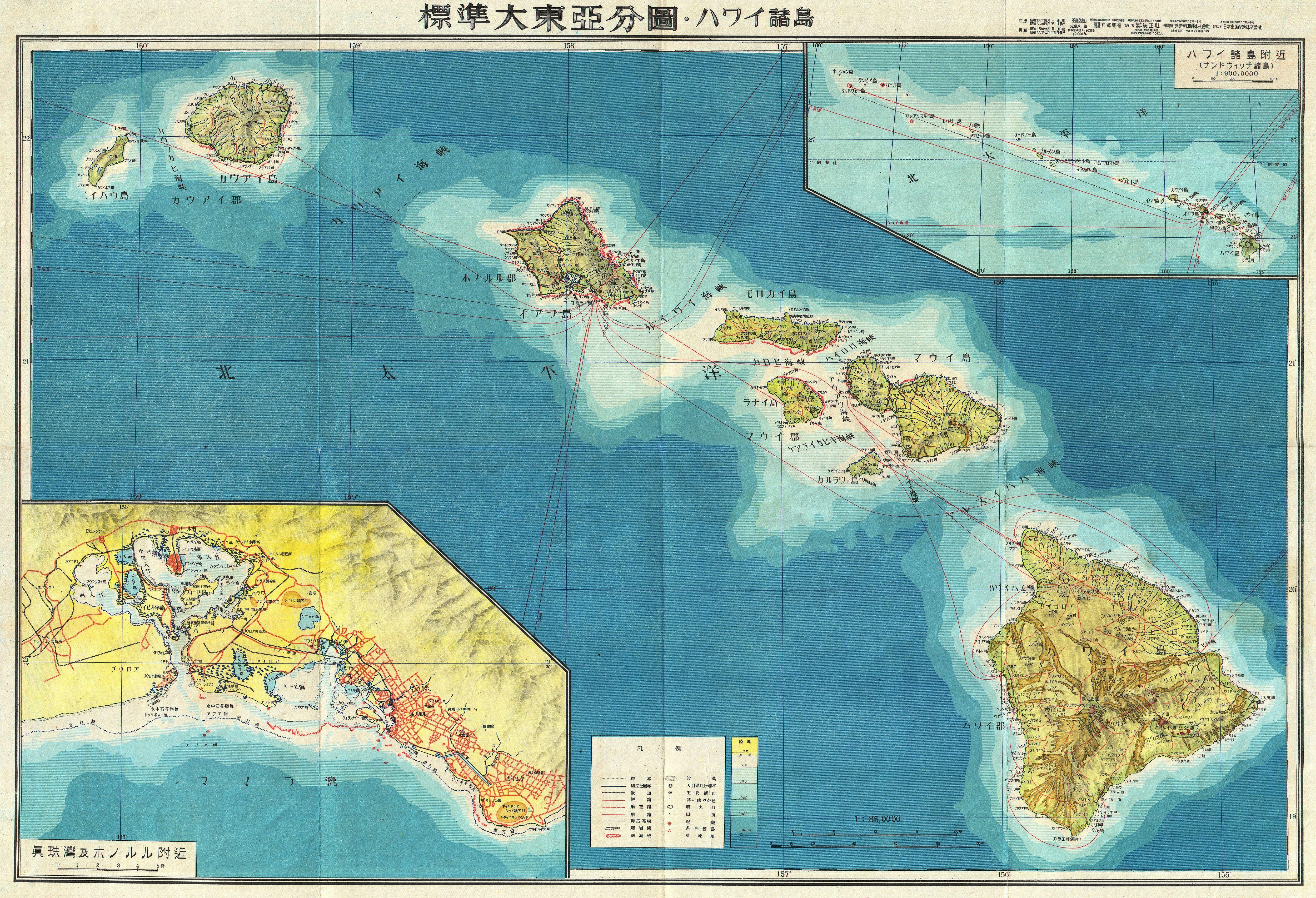
| Title |
Hawaii |
||||
| Description |
English: One of the most beautiful maps of the Hawaiian Islands ever produced. A stunning large format Japanese map of Hawaiian Island group dating to World War II. Covers the entirety of the Hawaiian Islands with a large inset city plan of Honolulu in the lower left quadrant. Another inset in the upper right quadrant shows the Hawaiian Islands relative to other Pacific Islands in the greater vicinity. Offers superb detail regarding both topographical and political elements. Notes cities, roads, trade routes on air, sea and land, and uses shading to display oceanic depths. Scale of 1:85,000. All text in Japanese. This map was created as part of a 20 piece series of folding maps of parts of Asia and the Pacific prepared by the Japanese during World War II. This map is no. 18 in that series. |
||||
| Date | 1943 (undated) | ||||
| Dimensions | height: 20 in (50.8 cm); width: 29 in (73.6 cm) | ||||
| Accession number |
Geographicus link: Hawaii2-wwii-1943 |
||||
| Source/Photographer |
Independent Issue.
|
||||
| Permission (Reusing this file) |
|
||||

File history
Click on a date/time to view the file as it appeared at that time.
| Date/Time | Thumbnail | Dimensions | User | Comment | |
|---|---|---|---|---|---|
| current | 18:27, 17 March 2011 | | 5,000 × 3,412 (5.27 MB) | BotMultichill (talk | contribs) | {{subst:User:Multichill/Geographicus |link=http://www.geographicus.com/P/AntiqueMap/Hawaii2-wwii-1943 |product_name=1943 Japanese World War II Aeronautical Map of Hawaii (text in Japanese) |map_title=Hawaii |description=One of the most beautiful maps of t |
You cannot overwrite this file.
File usage on Commons
The following page uses this file:
_-_Geographicus_-_Hawaii2-wwii-1943.jpg)
_-_Geographicus_-_Hawaii2-wwii-1943.jpg&oldid=843701361)