File:1930-Adm.-karta-Evropejskoj-chasti-SSSR.-Srednevolzhskij-kraj-MordObl.jpg
Jump to navigation
Jump to search

Size of this preview: 734 × 600 pixels. Other resolutions: 294 × 240 pixels | 588 × 480 pixels | 940 × 768 pixels | 1,254 × 1,024 pixels | 1,322 × 1,080 pixels.
Original file (1,322 × 1,080 pixels, file size: 882 KB, MIME type: image/jpeg)
Captions
Captions
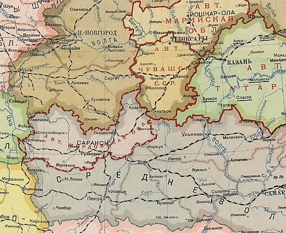
Erzya-Moksha Autonomy (Mordvin District) renamed Mordvin Autonomous Oblast before territorial changes, 1930
Summary[edit]
| Description |
Мокшень: Эрзя-Мокшень Автономие (Эрзя-Мокша Эль), Эрзя-Мокшень Автономонь Аймакс лемонц полафнемань пингста 1930 к., моданц кирьфтамда инголе |
| Date | |
| Source | http://sarpust.ru/2020/08/administrativno-territorialnoe-delenie-i-toponimika-blizhnego-prisarovya-sovetskogo-vremeni-chast-2-1929-1934g-g-rannemordovskij-period/ |
| Author | Archive map of Erzya-Moksha Autonomy (Mordvin Okrug) renamed to Mordvin Autonomous Oblast, 1930 |
Licensing[edit]
| This file is made available under the Creative Commons CC0 1.0 Universal Public Domain Dedication. | |
| The person who associated a work with this deed has dedicated the work to the public domain by waiving all of their rights to the work worldwide under copyright law, including all related and neighboring rights, to the extent allowed by law. You can copy, modify, distribute and perform the work, even for commercial purposes, all without asking permission.
|
File history
Click on a date/time to view the file as it appeared at that time.
| Date/Time | Thumbnail | Dimensions | User | Comment | |
|---|---|---|---|---|---|
| current | 16:39, 20 May 2022 | | 1,322 × 1,080 (882 KB) | Numulunj pilgae (talk | contribs) | Uploaded a work by Archive map of Erzya-Moksha Autonomy (Mordvin Okrug) renamed to Mordvin Autonomous Oblast, 1930 from http://sarpust.ru/2020/08/administrativno-territorialnoe-delenie-i-toponimika-blizhnego-prisarovya-sovetskogo-vremeni-chast-2-1929-1934g-g-rannemordovskij-period/ with UploadWizard |
You cannot overwrite this file.
File usage on Commons
There are no pages that use this file.
File usage on other wikis
The following other wikis use this file:
- Usage on en.wikipedia.org
- Usage on ru.wikipedia.org