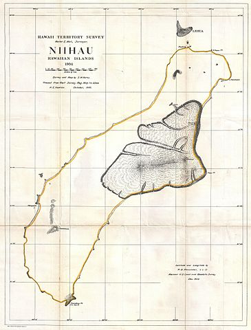
File:1904 Land Office Map of Niihau, Hawaii - Geographicus - Niihau-lo-1904.jpg

Original file (3,804 × 5,000 pixels, file size: 2.66 MB, MIME type: image/jpeg)
Captions
Captions
| Hawaii Territory Survey, Niihau Hawaiian Islands, 1904. | ||||||
|---|---|---|---|---|---|---|
| Artist | ||||||
| Title |
Hawaii Territory Survey, Niihau Hawaiian Islands, 1904. |
|||||
| Description |
English: This rare and extraordinary 1904 map of the island of Niihau was prepared for the 1906 Report of the Governor of the Territory of Hawaii to the Secretary of the Interior . The Report was an attempt to assess and examine the newly created Hawaiian Territory’s potential for proper administration and development. Depicts the islands topographical details. Prepared H. E. Newton from a survey originally drawn by S. M. Kerns. |
|||||
| Date | 1906 (dated) | |||||
| Dimensions | height: 25.5 in (64.7 cm); width: 19.5 in (49.5 cm) | |||||
| Accession number |
Geographicus link: Niihau-lo-1904 |
|||||
| Source/Photographer |
Report of the Governor of the Territory of Hawaii to the Secretary of the Interior, (1906 edition).
|
|||||
| Permission (Reusing this file) |
|
|||||
File history
Click on a date/time to view the file as it appeared at that time.
| Date/Time | Thumbnail | Dimensions | User | Comment | |
|---|---|---|---|---|---|
| current | 19:59, 16 March 2011 | | 3,804 × 5,000 (2.66 MB) | BotMultichill (talk | contribs) | {{subst:User:Multichill/Geographicus |link=http://www.geographicus.com/P/AntiqueMap/Niihau-lo-1904 |product_name=1904 Land Office Map of Niihau, Hawaii |map_title=Hawaii Territory Survey, Niihau Hawaiian Islands, 1904. |description=This rare and extraordi |
You cannot overwrite this file.
File usage on Commons
The following page uses this file: