File:1878PRINCIPAT.png
Jump to navigation
Jump to search

Size of this preview: 800 × 450 pixels. Other resolutions: 320 × 180 pixels | 640 × 360 pixels | 1,024 × 576 pixels | 1,280 × 720 pixels | 3,445 × 1,937 pixels.
Original file (3,445 × 1,937 pixels, file size: 587 KB, MIME type: image/png)
Captions
Captions
Add a one-line explanation of what this file represents
Summary[edit]
| Description |
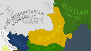
English: The Carpatho-Danubian-Pontic Space in 1878 AD, after the Treaty of Berlin and the international recognition of Romania's independence. |
| Date | |
| Source | Own work |
| Author | NeimWiki |
Licensing[edit]
I, the copyright holder of this work, hereby publish it under the following license:
This file is licensed under the Creative Commons Attribution-Share Alike 4.0 International license.
- You are free:
- to share – to copy, distribute and transmit the work
- to remix – to adapt the work
- Under the following conditions:
- attribution – You must give appropriate credit, provide a link to the license, and indicate if changes were made. You may do so in any reasonable manner, but not in any way that suggests the licensor endorses you or your use.
- share alike – If you remix, transform, or build upon the material, you must distribute your contributions under the same or compatible license as the original.
File history
Click on a date/time to view the file as it appeared at that time.
| Date/Time | Thumbnail | Dimensions | User | Comment | |
|---|---|---|---|---|---|
| current | 07:11, 16 July 2023 | | 3,445 × 1,937 (587 KB) | NeimWiki (talk | contribs) | Redid the Dobrujan border again. |
| 18:20, 15 July 2023 |  | 3,445 × 1,937 (587 KB) | NeimWiki (talk | contribs) | Redid the Dobrujan border again, as it was delimitated by the end of 1878 by the European Commission, just slightly modified in 1880. | |
| 17:57, 15 July 2023 |  | 3,445 × 1,937 (586 KB) | NeimWiki (talk | contribs) | Coastal visual mistake fixed. | |
| 17:56, 15 July 2023 |  | 3,445 × 1,937 (579 KB) | NeimWiki (talk | contribs) | Removed the Dobrujan border entirely, as it was not delimitated. | |
| 17:47, 15 July 2023 |  | 3,445 × 1,937 (579 KB) | NeimWiki (talk | contribs) | Removed my text box. | |
| 17:46, 15 July 2023 |  | 4,400 × 1,937 (699 KB) | NeimWiki (talk | contribs) | Redid the Dobrujan border, as it was not delimitated until a Boundary Commission in August-September 1880. | |
| 23:19, 2 July 2023 |  | 3,445 × 1,937 (587 KB) | NeimWiki (talk | contribs) | Fixed visual mistake south of Novi Pazar | |
| 23:03, 2 July 2023 |  | 3,445 × 1,937 (587 KB) | NeimWiki (talk | contribs) | Uploaded while editing "User:NeimWiki" on en.wikipedia.org |
You cannot overwrite this file.
File usage on Commons
The following page uses this file:
File usage on other wikis
The following other wikis use this file:
- Usage on en.wikipedia.org
- Usage on ro.wikipedia.org