File:1873 Beers Map of Sag Harbor, New York - Geographicus - SagHarborEastHampton-beers-1873 (cropped).jpg

Original file (4,810 × 3,058 pixels, file size: 4.58 MB, MIME type: image/jpeg)
Captions
Captions
| East Hampton, Suffolk Co. L.I. - Sag Harbor, Suffolk Co. | ||||||
|---|---|---|---|---|---|---|
| Artist | ||||||
| Title |
East Hampton, Suffolk Co. L.I. - Sag Harbor, Suffolk Co. |
|||||
| Description |
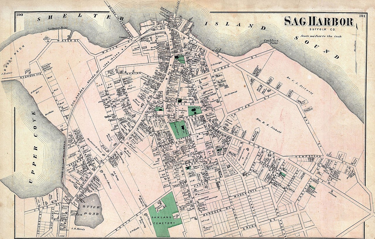
English: A scarce example of Fredrick W. Beers’ map of the Sag Harbor and East Hampton, Long Island, New York. Published in 1873. On the Sag Harbor Side, this magnificent map covers the town of Sag Harbor in considerable detail from the Upper Cove to Shelter Island Sound. Details individual streets and properties. On the East Hampton side the sheet is divided into four maps detailed the general region of East Hampton from Wainscott and Sag Harbor eastwards past East Hampton, Amagansett to Gardiners Island and Napeague Harbor. Shows parts of Gardiners Island including the estate of S. B. Gardiner. Smaller maps detail the towns of East Hampton, Amagansett and Bridgehampton with notations for individual buildings and properties. This is probably the finest atlas map of Sag Harbor and East Hampton to appear in the 19th century. Prepared by Beers, Comstock & Cline out of their office at 36 Vesey Street, New York City, for inclusion in the first published atlas of Long Island, the 1873 issue of Atlas of Long Island, New York. |
|||||
| Date | 1873 (undated) | |||||
| Dimensions | height: 14.5 in (36.8 cm); width: 24 in (60.9 cm) | |||||
| Accession number |
Geographicus link: SagHarborEastHampton-beers-1873 |
|||||
| Source/Photographer |
Atlas of Long Island, New York. From Recent Actual Surveys and Records Under the Superintendence of F. W. Beers. (1873 First Edition).
|
|||||
| Permission (Reusing this file) |
|
|||||
| Other versions | File:Sag Harbor, Suffolk Co. NYPL1527358.tiff | |||||

File history
Click on a date/time to view the file as it appeared at that time.
| Date/Time | Thumbnail | Dimensions | User | Comment | |
|---|---|---|---|---|---|
| current | 06:39, 21 February 2021 | | 4,810 × 3,058 (4.58 MB) | Ooligan (talk | contribs) | File:1873 Beers Map of East Hampton and Sag Harbor, Long Island, New York - Geographicus - SagHarborEastHampton-beers-1873.jpg cropped 4 % horizontally, 52 % vertically using CropTool with lossless mode. |
You cannot overwrite this file.
File usage on Commons
The following 2 pages use this file:
.jpg)
.jpg&oldid=745902034)