File:1868 Vaux and Olmstead Map of Prospect Park, Brooklyn, New York - Geographicus - ProspectPark-bishop-1868.jpg

Original file (4,000 × 2,526 pixels, file size: 2.26 MB, MIME type: image/jpeg)
Captions
Captions
| Design for Prospect Park as Proposed to be Laid Out for The City of Brooklyn. | ||||||
|---|---|---|---|---|---|---|
| Artist | ||||||
| Title |
Design for Prospect Park as Proposed to be Laid Out for The City of Brooklyn. |
|||||
| Description |
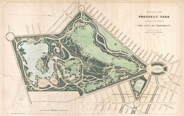
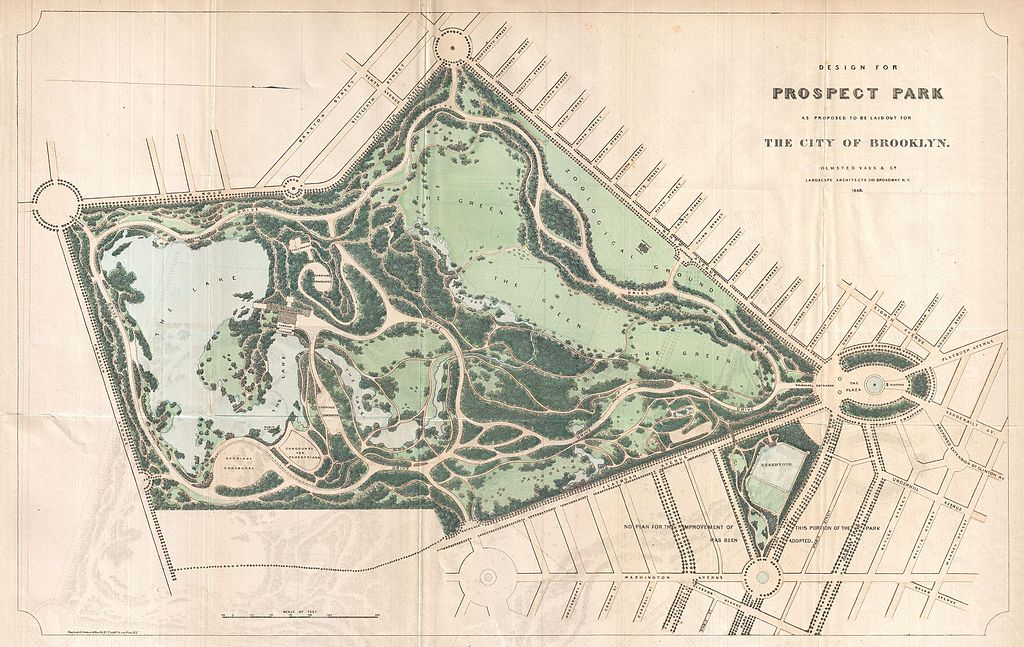
English: A rare 1868 first edition of Vaux & Olmstead's map of Prospect Park, Brooklyn. Issued just months after its October 1867 completion, this is one of the first published maps to depict the design of Prospect Park. Depicts the park as a whole and includes pathways, lakes, buildings, individual trees, rocks, and elevation measurements. The streets and avenues surrounding the park are also noted. This extraordinary map reveals Prospect Park as conceived by the landscape architects, and indeed “Artists”, Vaux and Olmstead. Vaux and Olmstead were awarded the task of designing Prospect Park in 1866 by the Brooklyn Common Council. Olmstead’s vision drove the overall design while Vaux concentrated his attentions on bridges, buildings, and other structures within the park. The creation of Prospect Park, which was to consist of some 585 acres of public forest, pathways, promenades, lakes, bridges, and meadows, was a seminal moment in civic urban design. The park itself was designed as a whole with every tree, pond, and bench meticulously planned. Olmstead wrote: “Every foot of the parks surface, every tree and bush, as well as every arch, roadway, and walk and been placed where it is for a purpose.” Though Olmstead is best known for his work in New York's Central Park, there are many who consider Prospect Park, his second masterpiece, to be his finest. Today, because of Vaux and Olmstead’s efforts, Brooklynites have the privilege of enjoying what is, without question, one of the finest example of a planned urban public recreation area in the world. |
|||||
| Date | 1868 (dated) | |||||
| Dimensions | height: 13 in (33 cm); width: 19.5 in (49.5 cm) | |||||
| Accession number |
Geographicus link: ProspectPark-bishop-1868 |
|||||
| Source/Photographer |
Bishop, William, Manual of the Common Council of the City of Brooklyn, 1864, 1864.
|
|||||
| Permission (Reusing this file) |
|
|||||
File history
Click on a date/time to view the file as it appeared at that time.
| Date/Time | Thumbnail | Dimensions | User | Comment | |
|---|---|---|---|---|---|
| current | 23:21, 24 March 2011 | | 4,000 × 2,526 (2.26 MB) | BotMultichillT (talk | contribs) | {{subst:User:Multichill/Geographicus |link=http://www.geographicus.com/P/AntiqueMap/ProspectPark-bishop-1868 |product_name=1868 Vaux and Olmstead Map of Prospect Park, Brooklyn, New York |map_title=Design for Prospect Park as Proposed to be Laid Out for T |
You cannot overwrite this file.
File usage on Commons
The following page uses this file:
File usage on other wikis
The following other wikis use this file:
- Usage on en.wikipedia.org