File:1865 Spruner Map of Northwestern Africa, the Magreb, and the Barbary Coast in Antiquity - Geographicus - Maghreb-spruner-1865.jpg
Jump to navigation
Jump to search

Size of this preview: 697 × 599 pixels. Other resolutions: 279 × 240 pixels | 558 × 480 pixels | 893 × 768 pixels | 1,191 × 1,024 pixels | 2,381 × 2,048 pixels | 3,500 × 3,010 pixels.
Original file (3,500 × 3,010 pixels, file size: 2.78 MB, MIME type: image/jpeg)
Captions
Captions
Add a one-line explanation of what this file represents
| Karl Spruner von Merz: Cyrenaica, Africa, Mauretania
( |
||||||||||||||||||||
|---|---|---|---|---|---|---|---|---|---|---|---|---|---|---|---|---|---|---|---|---|
| Artist |
|
|||||||||||||||||||
| Title |
Cyrenaica, Africa, Mauretania |
|||||||||||||||||||
| Description |
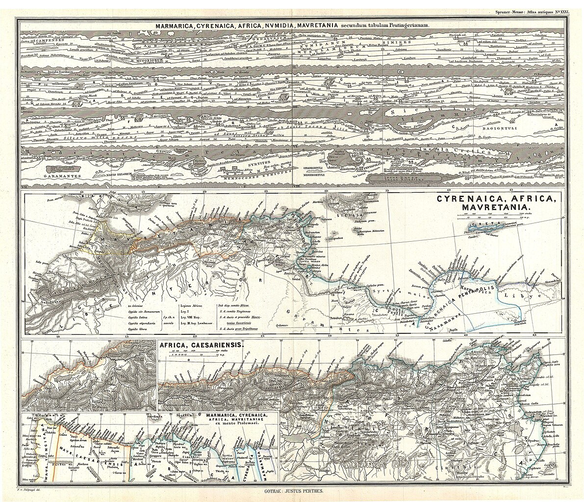
English: This is Karl von Spruner’s 1865 map of Cyrenaica, Africa, and Mauretania, collectively known as The Maghreb. Presently, the Maghreb makes up the areas of Morocco, Algeria, Tunisia, Libya, Mauritania and the disputed territory of Western Sahara. Essentially three maps in one, this charts includes the Peutinger Table, named after Konrad Peutinger, who discovered the map in 1508. The Peutinger Map is an astoundingly important discovery that is today’s only known example of a Roman world map, though the original Peutinger was itself a Mediaeval copy of the Roman original. The center map is Northern Africa and the island of Sicily. At the bottom are maps featuring Caesaria, the capital of the Roman province located in Northern Africa, and Marmarica. Map labels important cities, rivers, mountain ranges and other minor topographical detail. Territories and countries outlined in color. The whole is rendered in finely engraved detail exhibiting throughout the fine craftsmanship of the Perthes firm. |
|||||||||||||||||||
| Date | 1865 (undated) | |||||||||||||||||||
| Dimensions | height: 13 in (33 cm); width: 16 in (40.6 cm) | |||||||||||||||||||
| Accession number |
Geographicus link: Maghreb-spruner-1865 |
|||||||||||||||||||
| Source/Photographer |
Spruner, Karl von, Spruner-Menke Atlas Antiquus,, (Gotha: Justus Perthes), 1865.
|
|||||||||||||||||||
| Permission (Reusing this file) |
|
|||||||||||||||||||
File history
Click on a date/time to view the file as it appeared at that time.
| Date/Time | Thumbnail | Dimensions | User | Comment | |
|---|---|---|---|---|---|
| current | 06:03, 25 March 2011 | | 3,500 × 3,010 (2.78 MB) | BotMultichillT (talk | contribs) | {{subst:User:Multichill/Geographicus |link=http://www.geographicus.com/P/AntiqueMap/Maghreb-spruner-1865 |product_name=1865 Spruner Map of Northwestern Africa, the Magreb, and the Barbary Coast in Antiquity |map_title=Cyrenaica, Africa, Mauretania |descri |
You cannot overwrite this file.
File usage on Commons
The following page uses this file: