File:1864 U.S.C.S. Chart of the Mississippi River Grand Gulf to New Carthage (Jefferson Davis Plantation) - Geographicus - MissRive2Col-USCS-1864.jpg

Original file (3,200 × 4,000 pixels, file size: 2.3 MB, MIME type: image/jpeg)
Captions
Captions
| Mississippi River Grand Gulf, Turner’s Point, New Carthage Reconnaissance for the use of the Mississippi Squadron | ||||||
|---|---|---|---|---|---|---|
| Artist | ||||||
| Title |
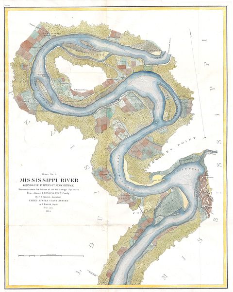
Mississippi River Grand Gulf, Turner’s Point, New Carthage Reconnaissance for the use of the Mississippi Squadron |
|||||
| Description |
English: This is a beautiful hand colored 1864 United States Costal Survey chart or map of a sinuous part of the Mississippi River from Grand Gulf, Mississippi to New Carthage, Louisiana. The bends in the river are named, as are the many river islands shown. Notes towns, wood lots, landings and farms, many of which are shown with family names. This map is especially important for Civil War buffs as it includes the Jefferson Davis Plantation. This map was created under the direction of A. D. Bache, Superintendent of the Survey of the Coast of the United States and one of the most influential American cartographers of the 19th century. |
|||||
| Date | 1864 | |||||
| Dimensions | height: 17 in (43.1 cm); width: 21 in (53.3 cm) | |||||
| Accession number |
Geographicus link: MissRive2Col-USCS-1864 |
|||||
| Source/Photographer |
|
|||||
| Permission (Reusing this file) |
|
|||||
File history
Click on a date/time to view the file as it appeared at that time.
| Date/Time | Thumbnail | Dimensions | User | Comment | |
|---|---|---|---|---|---|
| current | 14:13, 24 March 2011 | | 3,200 × 4,000 (2.3 MB) | BotMultichillT (talk | contribs) | {{subst:User:Multichill/Geographicus |link=http://www.geographicus.com/P/AntiqueMap/MissRive2Col-USCS-1864 |product_name=1864 U.S.C.S. Chart of the Mississippi River Grand Gulf to New Carthage (Jefferson Davis Plantation) |map_title=Mississippi River Gran |
You cannot overwrite this file.
File usage on Commons
The following page uses this file:
_-_Geographicus_-_MissRive2Col-USCS-1864.jpg)
File usage on other wikis
The following other wikis use this file:
- Usage on en.wikipedia.org
- Usage on en.wiktionary.org
_-_Geographicus_-_MissRive2Col-USCS-1864.jpg&oldid=826389414)
- United States Coast Survey maps
- Maps from Geographicus
- Mississippi River in Mississippi (state)
- Mississippi River in Louisiana
- Old maps of Louisiana
- Old maps of Mississippi (state)
- 1864 maps of the United States
- 1864 in Louisiana
- 1864 in Mississippi
- Maps of the American Civil War
- Brierfield Plantation
- Hurricane Plantation
- Maps of the Mississippi River
- Mississippi River in the 19th century