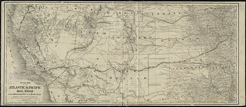
File:1860s Detail map of the Atlantic & Pacific Rail Road from the Mississippi River to the Pacific Ocean, by G.W. & C.B. Colton & Co, from the Digital Commonwealth - commonwealth cj82kn772.jpg
Jump to navigation
Jump to search

Size of this preview: 800 × 349 pixels. Other resolutions: 320 × 139 pixels | 640 × 279 pixels | 1,024 × 446 pixels | 1,280 × 558 pixels | 2,560 × 1,115 pixels | 11,696 × 5,096 pixels.
Original file (11,696 × 5,096 pixels, file size: 76.23 MB, MIME type: image/jpeg)
Captions
Captions
Add a one-line explanation of what this file represents
Summary
[edit]
| Description |
English: 1860s Detail map of the Atlantic & Pacific Rail Road from the Mississippi River to the Pacific Ocean, by G.W. & C.B. Colton & Co, from the Digital Commonwealth - commonwealth cj82kn772. (nnhttps://www.digitalcommonwealth.org/search/commonwealth:cj82kn772 |
| Date | 1860s |
| Source | Digital Commonwealth |
| Author | G.W. & C.B. Colton & Co |
Licensing
[edit]
|
This work is in the public domain in its country of origin and other countries and areas where the copyright term is the author's life plus 70 years or fewer. This work is in the public domain in the United States because it was published (or registered with the U.S. Copyright Office) before January 1, 1929. | |
| This file has been identified as being free of known restrictions under copyright law, including all related and neighboring rights. | |
File history
Click on a date/time to view the file as it appeared at that time.
| Date/Time | Thumbnail | Dimensions | User | Comment | |
|---|---|---|---|---|---|
| current | 19:07, 5 December 2021 | | 11,696 × 5,096 (76.23 MB) | Daderot (talk | contribs) | Uploaded a work by G.W. & C.B. Colton & Co from Digital Commonwealth with UploadWizard |
You cannot overwrite this file.
File usage on Commons
The following 3 pages use this file: