File:1855 Colton Map of Cuba, Jamaica and Porto Rico - Geographicus - Cuba-colton-1855.jpg
Jump to navigation
Jump to search
Size of this preview: 721 × 600 pixels. Other resolutions: 289 × 240 pixels | 577 × 480 pixels | 923 × 768 pixels | 1,231 × 1,024 pixels | 2,462 × 2,048 pixels | 4,000 × 3,328 pixels.
Original file (4,000 × 3,328 pixels, file size: 4.1 MB, MIME type: image/jpeg)
Captions
Captions
Add a one-line explanation of what this file represents
| J. H. Colton: Cuba Jamaica and Porto Rico.
( |
|||||||||||||||||||||
|---|---|---|---|---|---|---|---|---|---|---|---|---|---|---|---|---|---|---|---|---|---|
| Artist |
|
||||||||||||||||||||
| Title |
Cuba Jamaica and Porto Rico. |
||||||||||||||||||||
| Description |
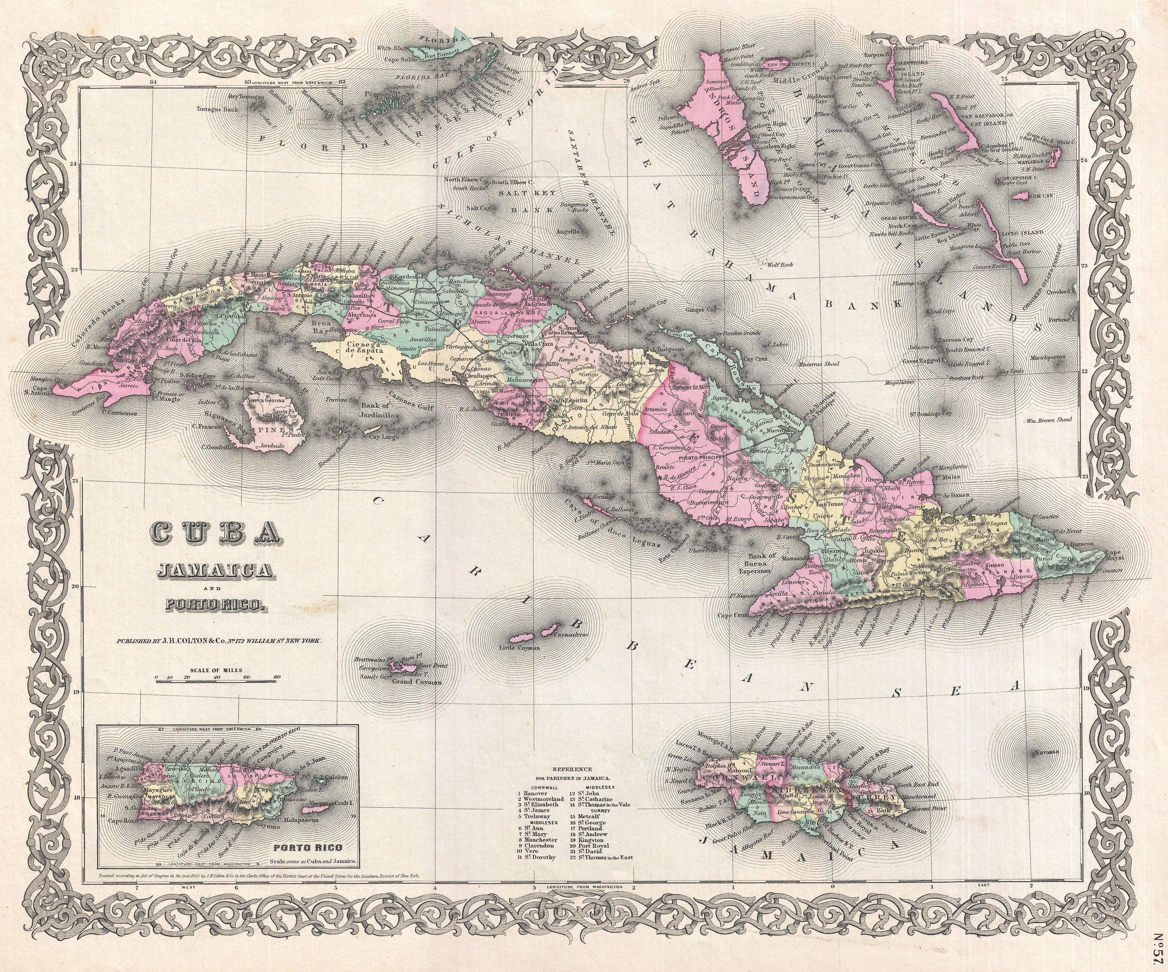
English: A beautiful 1855 first edition example of Colton's map of Cuba, Jamaica, Porto Rico and the Bahamas. Centered on Cuba, this map extends north to include the Florida Coast and New Providence Island, extends south as far A Jamaica. Includes the Cayman Islands and a detailed inset of Porto Rico in the lower left quadrant. Like most of Colton's North America maps, this map is largely derived from an earlier wall map of North America produced by Colton and D. Griffing Johnson. Colton identifies various cities, towns, forts, rivers, rapids, fords, and an assortment of additional offshore and topographical details. Map is hand colored in pink, green, yellow and blue pastels to define national and regional boundaries. Surrounded by Colton's typical spiral motif border. Dated and copyrighted to J. H. Colton, 1855. Published from Colton's 172 William Street Office in New York City. Issued as page no.57 in volume 1 of the first edition of George Washington Colton's 1855 Atlas of the World . |
||||||||||||||||||||
| Date | 1855 (dated) | ||||||||||||||||||||
| Dimensions | height: 13 in (33 cm); width: 16 in (40.6 cm) | ||||||||||||||||||||
| Accession number |
Geographicus link: Cuba-colton-1855 |
||||||||||||||||||||
| Source/Photographer |
Colton, G. W., Colton's Atlas of the World Illustrating Physical and Political Geography, Vol 1, New York, 1855 (First Edition).
|
||||||||||||||||||||
| Permission (Reusing this file) |
|
||||||||||||||||||||

File history
Click on a date/time to view the file as it appeared at that time.
| Date/Time | Thumbnail | Dimensions | User | Comment | |
|---|---|---|---|---|---|
| current | 12:24, 23 March 2011 | | 4,000 × 3,328 (4.1 MB) | BotMultichillT (talk | contribs) | {{subst:User:Multichill/Geographicus |link=http://www.geographicus.com/P/AntiqueMap/Cuba-colton-1855 |product_name=1855 Colton Map of Cuba, Jamaica and Porto Rico |map_title=Cuba Jamaica and Porto Rico. |description=A beautiful 1855 first edition example |
You cannot overwrite this file.
File usage on Commons
The following page uses this file: