File:1852 Bellin Map of Sumatra, Malaca, and Singapore - Geographicus - Sumatra-bellin-1750.jpg
Jump to navigation
Jump to search

Size of this preview: 701 × 600 pixels. Other resolutions: 281 × 240 pixels | 561 × 480 pixels | 898 × 768 pixels | 1,197 × 1,024 pixels | 2,394 × 2,048 pixels | 3,000 × 2,566 pixels.
Original file (3,000 × 2,566 pixels, file size: 1.61 MB, MIME type: image/jpeg)
Captions
Captions
Add a one-line explanation of what this file represents
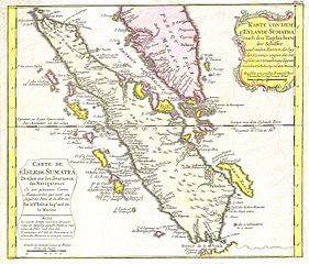
| Jacques-Nicolas Bellin: Karte von Dem Eylande Sumatra nach den Tagebuchern der Schiffer - Carte de l’Isle de Sumatra Drefsee sur les Journaux des Navigatuers.
( |
||||||||||||||||||||
|---|---|---|---|---|---|---|---|---|---|---|---|---|---|---|---|---|---|---|---|---|
| Artist |
|
|||||||||||||||||||
| Title |
Karte von Dem Eylande Sumatra nach den Tagebuchern der Schiffer - Carte de l’Isle de Sumatra Drefsee sur les Journaux des Navigatuers. |
|||||||||||||||||||
| Description |
English: This is a beautiful map of the island of Sumatra and the southern tip of the Malaysian Peninsula was produced by the French Cartographer Jacques-Nicolas Bellin. Depicts the entirety of Sumatra as well as much of modern day Malaysia. Includes the Straights of Singapore (Sincapour). Two decorative title cartouches decorate the map, one in French and one in German. This, the German edition, of is excpetionally rare. |
|||||||||||||||||||
| Date | 1852 | |||||||||||||||||||
| Dimensions | height: 10 in (25.4 cm); width: 11.5 in (29.2 cm) | |||||||||||||||||||
| Accession number |
Geographicus link: Sumatra-bellin-1750 |
|||||||||||||||||||
| Source/Photographer |
|
|||||||||||||||||||
| Permission (Reusing this file) |
|
|||||||||||||||||||
File history
Click on a date/time to view the file as it appeared at that time.
| Date/Time | Thumbnail | Dimensions | User | Comment | |
|---|---|---|---|---|---|
| current | 21:42, 24 March 2011 | | 3,000 × 2,566 (1.61 MB) | BotMultichillT (talk | contribs) | {{subst:User:Multichill/Geographicus |link=http://www.geographicus.com/P/AntiqueMap/Sumatra-bellin-1750 |product_name=1852 Bellin Map of Sumatra, Malaca, and Singapore |map_title=Karte von Dem Eylande Sumatra nach den Tagebuchern der Schiffer - Carte de l |
You cannot overwrite this file.
File usage on Commons
The following 2 pages use this file: