File:1848 Public Survey Map of Wisconsin - Geographicus - WI-gs-1848.jpg

From Wikimedia Commons, the free media repository
Jump to navigation Jump to search

Original file(2,500 × 2,181 pixels, file size: 848 KB, MIME type: image/jpeg)

Captions

Captions

Add a one-line explanation of what this file represents
A Sketch of the Public Surveys in Wisconsin.
Artist
Title
A Sketch of the Public Surveys in Wisconsin.
Description
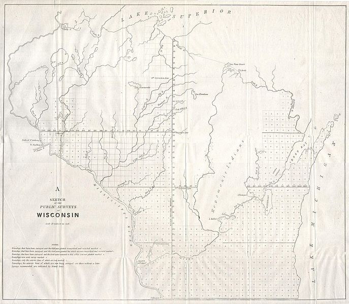
English: This magnificent map of Wisconsin was issued in 1848 for the U.S. Land Survey Office. It is officially entitled “A Sketch of the Public Surveys in Wisconsin”. This large map reveals the State of Wisconsin in wonderful detail, including numerous historically important references, including but not limited to Oneida Indian and Memomonie Indian territory, geographic features such are falls and rivers, and important forts and settlements such as Fort Snelling and Prairie de Chien.
Date 1848
date QS:P571,+1848-00-00T00:00:00Z/9
Dimensions height: 18 in (45.7 cm); width: 21 in (53.3 cm)
dimensions QS:P2048,18U218593
dimensions QS:P2049,21U218593
Accession number
Geographicus link: WI-gs-1848
Source/Photographer
Permission
(Reusing this file)
This is a faithful photographic reproduction of a two-dimensional, public domain work of art. The work of art itself is in the public domain for the following reason:
Public domain

This work is in the public domain in its country of origin and other countries and areas where the copyright term is the author's life plus 70 years or fewer.


You must also include a United States public domain tag to indicate why this work is in the public domain in the United States. Note that a few countries have copyright terms longer than 70 years: Mexico has 100 years, Jamaica has 95 years, Colombia has 80 years, and Guatemala and Samoa have 75 years. This image may not be in the public domain in these countries, which moreover do not implement the rule of the shorter term. Honduras has a general copyright term of 75 years, but it does implement the rule of the shorter term. Copyright may extend on works created by French who died for France in World War II (more information), Russians who served in the Eastern Front of World War II (known as the Great Patriotic War in Russia) and posthumously rehabilitated victims of Soviet repressions (more information).

The official position taken by the Wikimedia Foundation is that "faithful reproductions of two-dimensional public domain works of art are public domain".
This photographic reproduction is therefore also considered to be in the public domain in the United States. In other jurisdictions, re-use of this content may be restricted; see Reuse of PD-Art photographs for details.
{{PD-Art}} template without license parameter: please specify why the underlying work is public domain in both the source country and the United States
(Usage: {{PD-Art|1=|deathyear=''year of author's death''|country=''source country''}}, where parameter 1= can be PD-old-auto, PD-old-auto-expired, PD-old-auto-1996, PD-old-100 or similar. See Commons:Multi-license copyright tags for more information.)

File history

Click on a date/time to view the file as it appeared at that time.

Date/TimeThumbnailDimensionsUserComment
current08:25, 16 March 2011Thumbnail for version as of 08:25, 16 March 20112,500 × 2,181 (848 KB)BotMultichill (talk | contribs){{subst:User:Multichill/Geographicus |link=http://www.geographicus.com/P/AntiqueMap/WI-gs-1848 |product_name=1848 Public Survey Map of Wisconsin |map_title=A Sketch of the Public Surveys in Wisconsin. |description=This magnificent map of Wisconsin was iss