File:1842 S.D.U.K. Map of the City of Calcutta, India - Geographicus - Calcutta-sduk-1842.jpg
Original file (3,500 × 2,800 pixels, file size: 2.45 MB, MIME type: image/jpeg)
Captions
Captions
| Title |
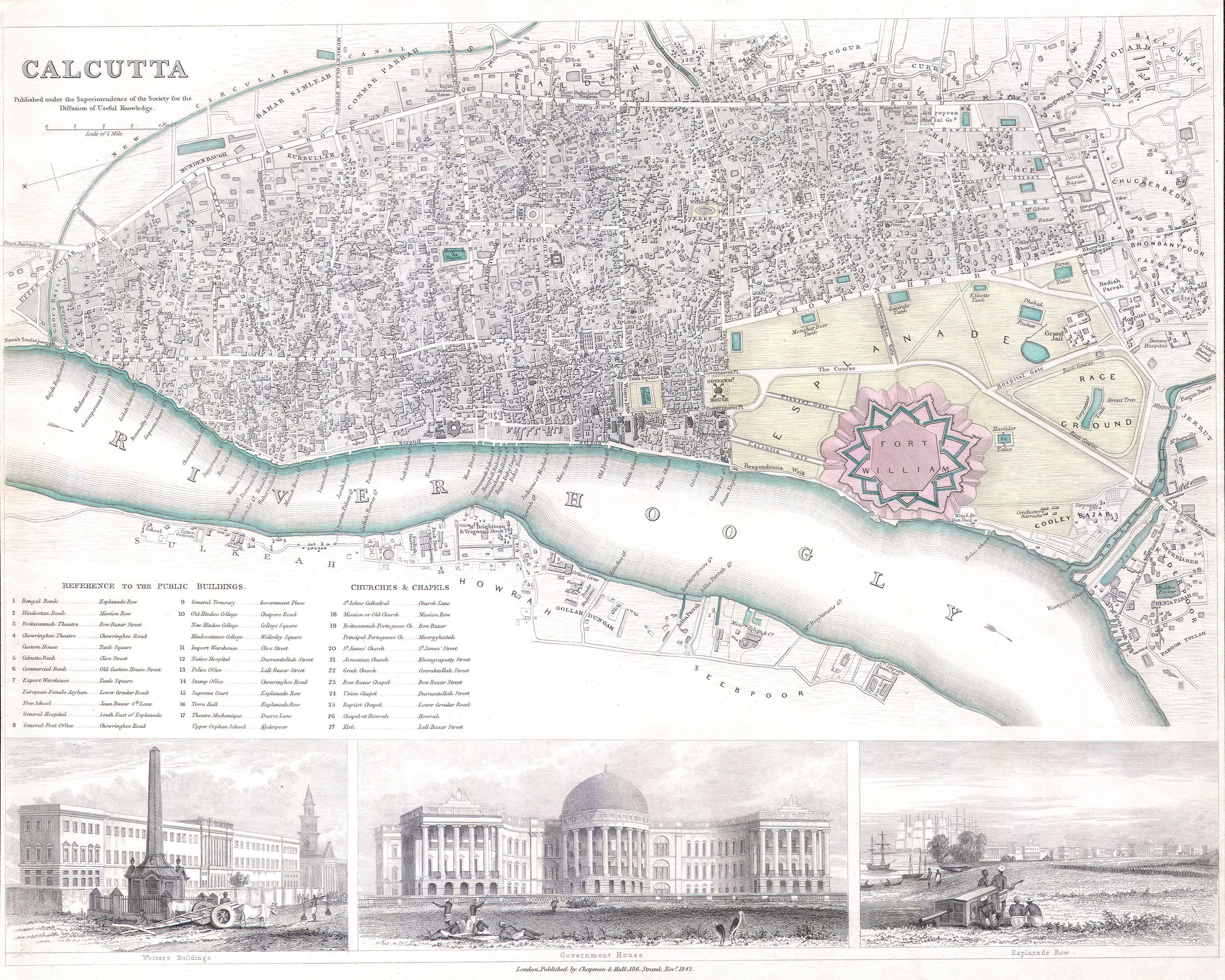
Calcutta. |
|||||||||
| Description |
English: This is a S.D.U.K. map or city plan of Calcutta, India. Calcutta was once the administrative capital of British India. The lower part of the map is decorated by several beautiful engraved illustrations of important Calcutta locations, including the Government House, Esplande Row, and the Writer’s Buildings. As much as possible individual streets are indicated as are souks and bazaars. Published by “Chapman and Hall of 186 Strand Street in November of 1842”. |
|||||||||
| Date | ||||||||||
| Source |
Maps of the Society for the Diffusion of Useful Knowledge. Vol1. 1844.
|
|||||||||
| Creator | ||||||||||
| Permission (Reusing this file) |
|
|||||||||
| Geotemporal data | ||||||||||
| Bounding box |
|
|||||||||
| Georeferencing | ||||||||||
| Archival data | ||||||||||
| Accession number |
Geographicus link: Calcutta-sduk-1842 |
|||||||||
| Dimensions | height: 12.5 in (31.7 cm); width: 16 in (40.6 cm) | |||||||||
| Other versions | ||||||||||


|
This image has been assessed under the valued image criteria and is considered the most valued image on Commons within the scope: Old maps of Kolkata from 1842.. You can see its nomination here. |
This image has been assessed using the Quality image guidelines and is considered a Quality image.
|
File history
Click on a date/time to view the file as it appeared at that time.
| Date/Time | Thumbnail | Dimensions | User | Comment | |
|---|---|---|---|---|---|
| current | 01:31, 25 March 2011 | | 3,500 × 2,800 (2.45 MB) | BotMultichillT (talk | contribs) | {{subst:User:Multichill/Geographicus |link=http://www.geographicus.com/P/AntiqueMap/Calcutta-sduk-1842 |product_name=1842 S.D.U.K. Map of the City of Calcutta, India |map_title=Calcutta. |description=This is a S.D.U.K. map or city plan of Calcutta, India. |
You cannot overwrite this file.
File usage on Commons
The following 6 pages use this file:
- User talk:Bodhisattwa/Archive/2018
- Commons:Quality images/Subject/Non photographic media
- Commons:Quality images candidates/Archives January 09 2024
- Commons:Valued image candidates/1842 S.D.U.K. Map of the City of Calcutta, India - Geographicus - Calcutta-sduk-1842.jpg
- File:Government House, Calcutta in 1842.jpg
- File:Writers' Building in 1842.jpg