File:1838 Monin Map or Physical Tableau and Astronomy Chart (Zodiac) - Geographicus - Tableau-monin-1838.jpg

Original file (3,000 × 2,281 pixels, file size: 1.65 MB, MIME type: image/jpeg)
Captions
Captions
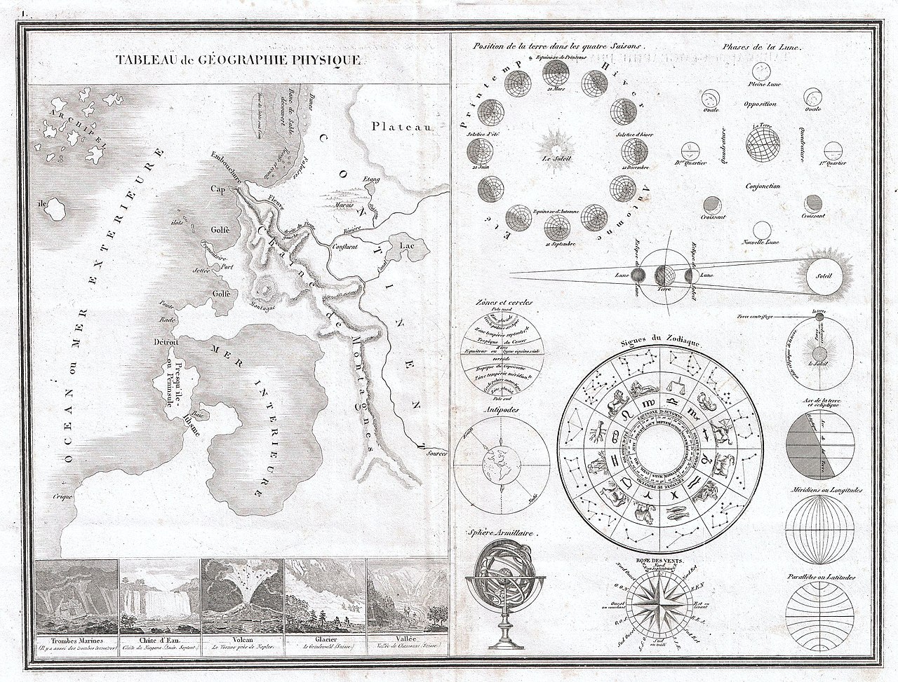
| Charles V. Monin: Tableau de Geographie Physique.
( |
||||||||||||||
|---|---|---|---|---|---|---|---|---|---|---|---|---|---|---|
| Artist |
|
|||||||||||||
| Title |
Tableau de Geographie Physique. |
|||||||||||||
| Description |
Français : Légendes: Tableau de géographie physique – Trombes Marines – Chûte d’Eau – Volcan – Glacier – Vallée – Position de la terre dans les quatre Saisons – Phases de la Lune – Zônes et cercles – Antipodes – Signes du Zodiaque – Sphère Armillaire – Rose des vents – Axe de la terre et écliptique – Méridiens ou Longitudes – Parallèles ou Latitudes.
English: This is a very unusual 1838 map and astronomical chart by M. Monin. Divided into two sections. The left section is a Geographical Tableau, essentially a map of nothing, showing various geographical features and how they can be displayed. Shows mountains, plains, gulfs, seas, archipelagos, swamps, lakes rivers and plateaus, among others. Along the bottom there are five engraved images of geographical sights and events including tornadoes at sea, a waterfall, a volcano erupting, a glacier and a valley. The right side of this map is a Astronomical chart, itself divided into various elements. Includes a diagram of the seasons, a map of the phases of the moon, a representation of the Zodiac, a lunar and solar eclipse diagram, an Armillary sphere, etc… Prepared by M.Monin as plate no. |
|||||||||||||
| Date | 1838 (undated) | |||||||||||||
| Dimensions | height: 10.5 in (26.6 cm); width: 14 in (35.5 cm) | |||||||||||||
| Accession number |
Geographicus link: Tableau-monin-1838 |
|||||||||||||
| Source/Photographer |
Atlas Classique de La Geographie Ancienne, du Moyen Age, et Moderne, a L'Usage des Colleges et des Pensiones pour servir a L'Etude de La Geographie et de L'Histoire, corrige et augemnte Par M. Monin, ingenieur-Geographe, membre de la Societe de Geographie. (1838 edition).
|
|||||||||||||
| Permission (Reusing this file) |
|
|||||||||||||
File history
Click on a date/time to view the file as it appeared at that time.
| Date/Time | Thumbnail | Dimensions | User | Comment | |
|---|---|---|---|---|---|
| current | 07:44, 18 March 2011 | | 3,000 × 2,281 (1.65 MB) | BotMultichill (talk | contribs) | {{subst:User:Multichill/Geographicus |link=http://www.geographicus.com/P/AntiqueMap/Tableau-monin-1838 |product_name=1838 Monin Map or Physical Tableau and Astronomy Chart (Zodiac) |map_title=Tableau de Geographie Physique. |description=This is a very unu |
You cannot overwrite this file.
File usage on Commons
The following page uses this file:
_-_Geographicus_-_Tableau-monin-1838.jpg)
File usage on other wikis
The following other wikis use this file:
- Usage on it.wikipedia.org
_-_Geographicus_-_Tableau-monin-1838.jpg&oldid=840024065)