File:1811 Cary Map of Arabia, Egypt ^ Abyssinia - Geographicus - Arabia-cary-1811.jpg
Jump to navigation
Jump to search

Size of this preview: 677 × 599 pixels. Other resolutions: 271 × 240 pixels | 542 × 480 pixels | 868 × 768 pixels | 1,157 × 1,024 pixels | 2,314 × 2,048 pixels | 4,000 × 3,540 pixels.
Original file (4,000 × 3,540 pixels, file size: 2.84 MB, MIME type: image/jpeg)
Captions
Captions
Add a one-line explanation of what this file represents
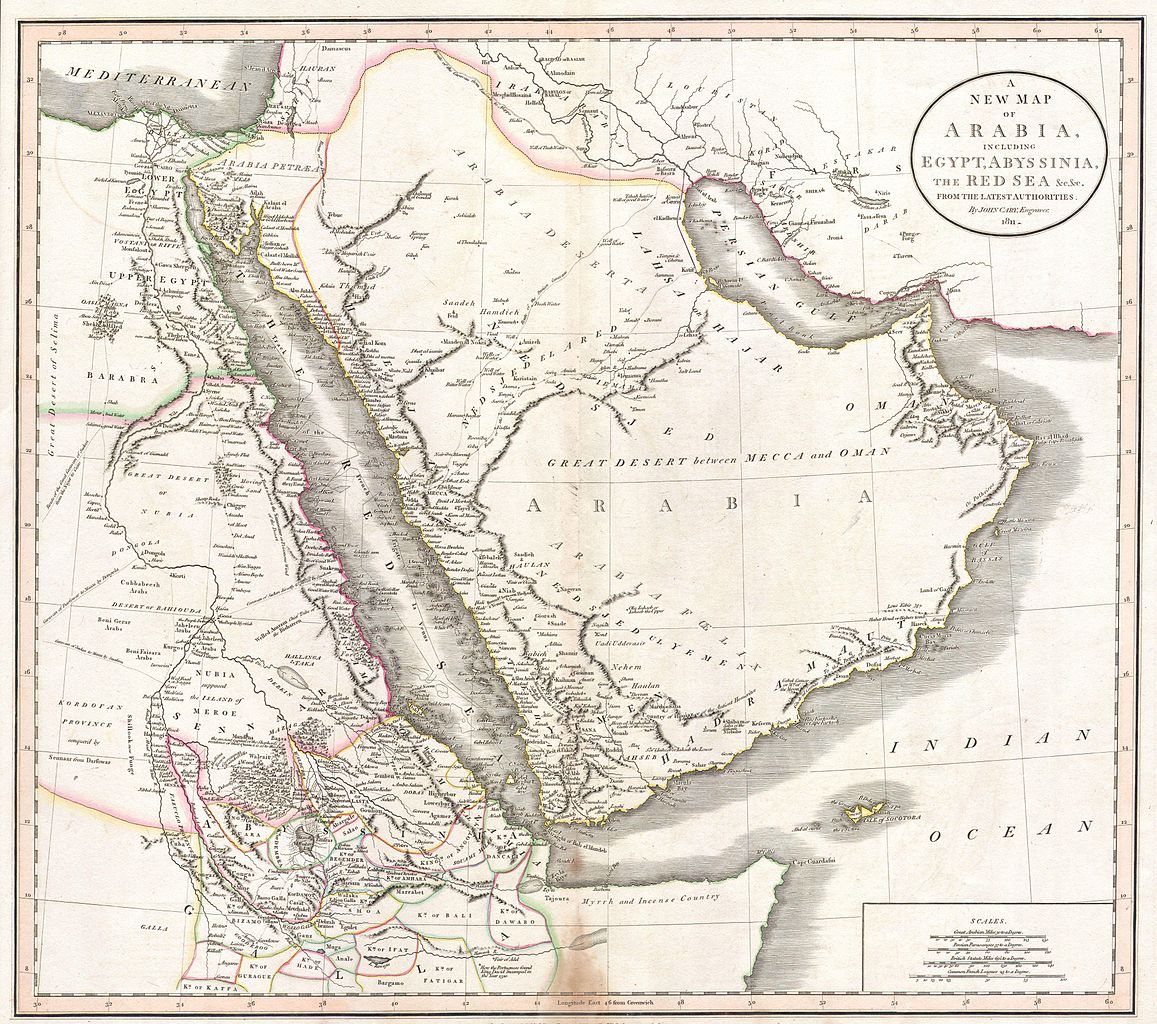
| John Cary: A New Map of Arabia, including Egypt, Abyssinia, the Red Sea & c. & c. from the latest Authorities.
( |
||||||||||||||||||||||||||
|---|---|---|---|---|---|---|---|---|---|---|---|---|---|---|---|---|---|---|---|---|---|---|---|---|---|---|
| Artist |
|
|||||||||||||||||||||||||
| Title |
A New Map of Arabia, including Egypt, Abyssinia, the Red Sea & c. & c. from the latest Authorities. |
|||||||||||||||||||||||||
| Description |
English: This is a stunning 1811 map of Arabia, Egypt and Abyssinia ( Ethiopia ) by English Cartographer John Cary. A smorgasbord of wonderful detail including historical notes, caravan routes, the locations of desert wells and oases, nautical routes, and tribal kingdoms. Contains such notations as “Here the Portuguese found King David encamped in the Year 1520” , referring to the Portuguese embassy to the King of Ethiopia; “Myrrh and Incense Country” on the Horn of Africa; and “Supposed Island of Meroe”, referring to the ancient pyramid building culture in the heard of what is today Sudan. Also of interest is the route of the Frigate 'La Venus', which charted the Red Sea, the Persian Gulf, and the Indian Ocean before disappearing in a hurricane with all crew and cargo in 1788. Dated 1811. |
|||||||||||||||||||||||||
| Date | 1811 | |||||||||||||||||||||||||
| Dimensions | height: 18 in (45.7 cm); width: 21 in (53.3 cm) | |||||||||||||||||||||||||
| Accession number |
Geographicus link: Arabia-cary-1811 |
|||||||||||||||||||||||||
| Source/Photographer |
|
|||||||||||||||||||||||||
| Other versions |
|
|||||||||||||||||||||||||
.jpg)

Licensing[edit]
|
This is a faithful photographic reproduction of a two-dimensional, public domain work of art. The work of art itself is in the public domain for the following reason:
The official position taken by the Wikimedia Foundation is that "faithful reproductions of two-dimensional public domain works of art are public domain".
This photographic reproduction is therefore also considered to be in the public domain in the United States. In other jurisdictions, re-use of this content may be restricted; see Reuse of PD-Art photographs for details. | ||||
File history
Click on a date/time to view the file as it appeared at that time.
| Date/Time | Thumbnail | Dimensions | User | Comment | |
|---|---|---|---|---|---|
| current | 18:19, 24 March 2011 | | 4,000 × 3,540 (2.84 MB) | BotMultichillT (talk | contribs) | {{subst:User:Multichill/Geographicus |link=http://www.geographicus.com/P/AntiqueMap/Arabia-cary-1811 |product_name=1811 Cary Map of Arabia, Egypt & Abyssinia |map_title=A New Map of Arabia, including Egypt, Abyssinia, the Red Sea & c. & c. from the latest |
You cannot overwrite this file.
File usage on Commons
The following 3 pages use this file:
File usage on other wikis
The following other wikis use this file:
- Usage on ar.wikipedia.org
- Usage on pnb.wikipedia.org
- Usage on ur.wikipedia.org