File:1796 Cary Folding Case Map of England ^ Wales - Geographicus - EnglandWales-cary-1793.jpg
Jump to navigation
Jump to search

Size of this preview: 496 × 600 pixels. Other resolutions: 198 × 240 pixels | 397 × 480 pixels | 635 × 768 pixels | 846 × 1,024 pixels | 1,693 × 2,048 pixels | 5,000 × 6,048 pixels.
Original file (5,000 × 6,048 pixels, file size: 7.78 MB, MIME type: image/jpeg)
Captions
Captions
Add a one-line explanation of what this file represents
| Artist |
|
|||||||||||||||||||||||||
| Title |
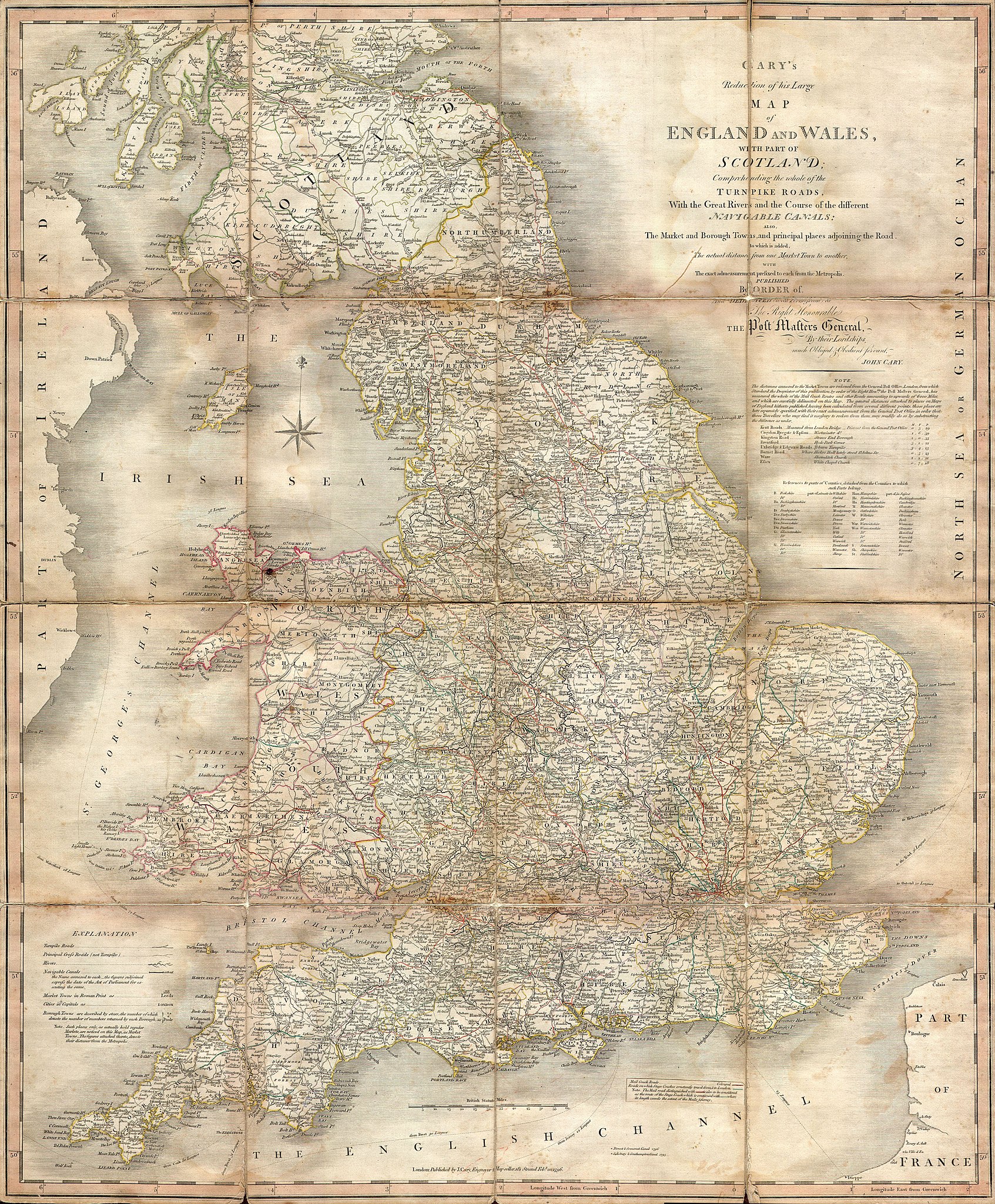
Cary’s Reduction of his Large Map of England and Wales, with part of Scotland; Comprehending the whole of the Turnpike Roads, With the Great Rivers and the Course of the different Navigable Canals: also The Market and Borough Town, and principal places adjoining the Road. To which is added, the Actual distance from one Market Town to another, with The exact admeasurement prefixed to each from the Metropolis. Published by Order of, and Dedicated with Permission to The Right Honorable the Post Masters General, by their Lordships, much Obliged & Obedient Servant, John Cary. |
|||||||||||||||||||||||||
| Description |
English: An important 1796 Case Map of England, Wales and the Southern part of Scotland by John Cary. This is in fact a reduction of Cary’s seminal and enormous large format map of England and Wales produced a few years previously. Map depicts the region in impressive detail with special attention to matters of trade and transport – roads, tolls, bridges, canals, etc. Dissected into 16 sheets and mounted on linen. Dated at base, Feb 20, 1796. |
|||||||||||||||||||||||||
| Date | 1796 | |||||||||||||||||||||||||
| Dimensions | height: 24 in (60.9 cm); width: 30 in (76.2 cm) | |||||||||||||||||||||||||
| Accession number |
Geographicus link: EnglandWales-cary-1793 |
|||||||||||||||||||||||||
| Source/Photographer |
|
|||||||||||||||||||||||||
| Permission (Reusing this file) |
|
|||||||||||||||||||||||||
File history
Click on a date/time to view the file as it appeared at that time.
| Date/Time | Thumbnail | Dimensions | User | Comment | |
|---|---|---|---|---|---|
| current | 18:32, 24 March 2011 | | 5,000 × 6,048 (7.78 MB) | BotMultichillT (talk | contribs) | {{subst:User:Multichill/Geographicus |link=http://www.geographicus.com/P/AntiqueMap/EnglandWales-cary-1793 |product_name=1796 Cary Folding Case Map of England & Wales |map_title=Cary’s Reduction of his Large Map of England and Wales, with part of Scotla |
You cannot overwrite this file.
File usage on Commons
The following page uses this file: