File:1794 Anville Map of Gaul (Gallia) or France in ancient Roman Times - Geographicus - France-anville-1794.jpg
Jump to navigation
Jump to search

Size of this preview: 758 × 600 pixels. Other resolutions: 303 × 240 pixels | 607 × 480 pixels | 971 × 768 pixels | 1,280 × 1,013 pixels | 2,560 × 2,026 pixels | 5,000 × 3,957 pixels.
Original file (5,000 × 3,957 pixels, file size: 6.15 MB, MIME type: image/jpeg)
Captions
Captions
Add a one-line explanation of what this file represents
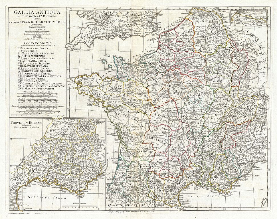
| Jean Baptiste Bourguignon d'Anville: Gallia Antiqua ex Aevi Romani Monumentis eruta et Serenissimi Carnutum Ducis Munificentia Publicijuris Facta.
( |
|||||||||||||||||||||
|---|---|---|---|---|---|---|---|---|---|---|---|---|---|---|---|---|---|---|---|---|---|
| Artist |
|
||||||||||||||||||||
| Title |
Gallia Antiqua ex Aevi Romani Monumentis eruta et Serenissimi Carnutum Ducis Munificentia Publicijuris Facta. |
||||||||||||||||||||
| Description |
English: A large and dramatic J. B. B. D'Anville map of Gallia or France in ancient Roman times. Covers from the southern part of England (Britannia) to the Pyrenees and the Mediterranean. Details mountains, rivers, cities, roadways, and lakes with political divisions highlighted in outline color. Features both ancient and contemporary place names, ie. Parisii and Paris, for each destination - an invaluable resource or scholars of antiquity. An inset in the lower left quadrant details Gallia's southern most Roman Provinces. A smaller inset labeled Batavorum Insulae appears in the upper right quadrant. Title area in upper left quadrant. Includes seven distance scales, top left, referencing various measurement systems common in antiquity. Text in Latin and English. Drawn by J. B. B. D'Anville in 1762 and published in 1794 by Laurie and Whittle, London. |
||||||||||||||||||||
| Date | dated 1760, published 1794 | ||||||||||||||||||||
| Dimensions | height: 18 in (45.7 cm); width: 23 in (58.4 cm) | ||||||||||||||||||||
| Accession number |
Geographicus link: France-anville-1794 |
||||||||||||||||||||
| Source/Photographer |
D'Anville, J. B. B., Complete Body of Ancient Geography, Laurie and Whittle, London, 1795.
|
||||||||||||||||||||
| Permission (Reusing this file) |
|
||||||||||||||||||||

File history
Click on a date/time to view the file as it appeared at that time.
| Date/Time | Thumbnail | Dimensions | User | Comment | |
|---|---|---|---|---|---|
| current | 14:42, 23 March 2011 | | 5,000 × 3,957 (6.15 MB) | BotMultichillT (talk | contribs) | {{subst:User:Multichill/Geographicus |link=http://www.geographicus.com/P/AntiqueMap/France-anville-1794 |product_name=1794 Anville Map of Gaul (Gallia) or France in ancient Roman Times |map_title=Gallia Antiqua ex Aevi Romani Monumentis eruta et Serenissi |
You cannot overwrite this file.
File usage on Commons
The following page uses this file:
_or_France_in_ancient_Roman_Times_-_Geographicus_-_France-anville-1794.jpg)
File usage on other wikis
The following other wikis use this file:
- Usage on fr.wikipedia.org
_or_France_in_ancient_Roman_Times_-_Geographicus_-_France-anville-1794.jpg&oldid=744743606)