File:1780 Raynal and Bonne Map of South Africa, Zimbabwe, Madagascar, and Mozambique - Geographicus - Mozambique-bonne-1780.jpg
Jump to navigation
Jump to search

Size of this preview: 800 × 556 pixels. Other resolutions: 320 × 222 pixels | 640 × 445 pixels | 1,024 × 711 pixels | 1,280 × 889 pixels | 2,500 × 1,737 pixels.
Original file (2,500 × 1,737 pixels, file size: 1.24 MB, MIME type: image/jpeg)
Captions
Captions
Add a one-line explanation of what this file represents
| Rigobert Bonne: Carte Du Canal De Mozambique
( |
|||||||||||||||||||||||
|---|---|---|---|---|---|---|---|---|---|---|---|---|---|---|---|---|---|---|---|---|---|---|---|
| Artist |
|
||||||||||||||||||||||
| Title |
Carte Du Canal De Mozambique |
||||||||||||||||||||||
| Description |
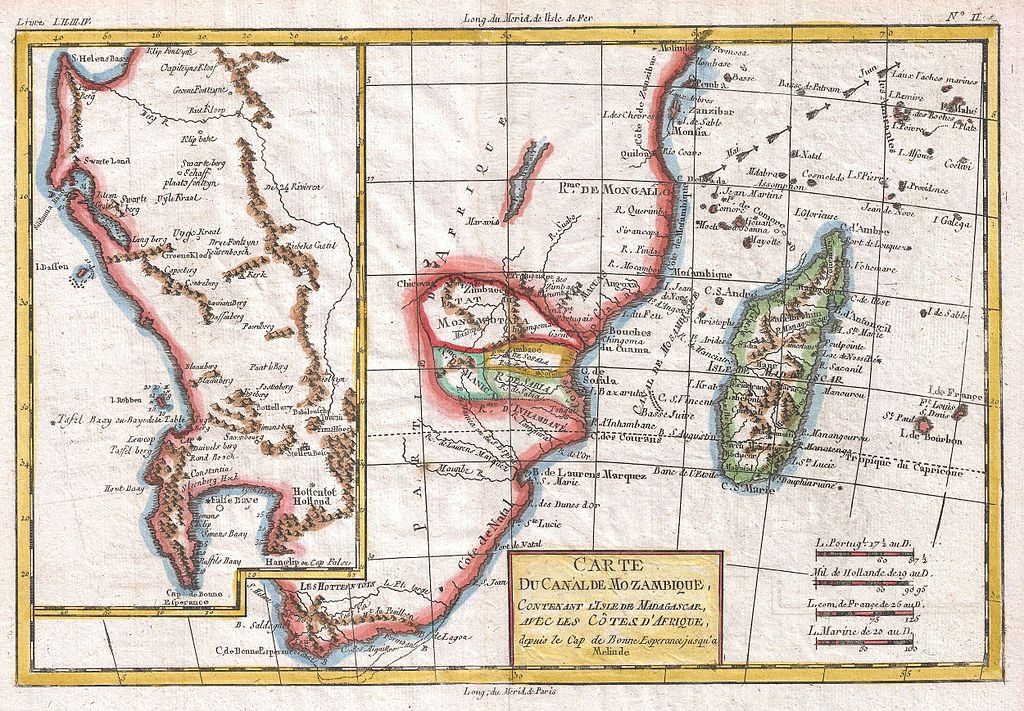
English: A fine example of Rigobert Bonne and G. Raynal’s 1780 map Southern Africa. Essentially two maps in one which, between them, cover the entire southern portion of the continent. The main map, on the right, covers from the Cape of Good Hope north as far as Zanzibar and modern day Kenya, focusing on the gold rich kingdom of Monomotapa. This region, today part of Mozambique and Zimbabwe, was once rich in gold and was often associated with the Biblical kingdom of Ophir, which is mentioned in the legend of King Solomon's Mines. This was one of the first parts of eastern Africa to be explored and colonized by Portuguese traders looking for a source of gold to rival that of the Spaniards in Mexico and Peru. Unfortunately for everyone involved the Mines of Solomon had been all but exhausted shortly before the Europeans arrived. Just north of Monomotapa a very embryonic mapping of Lake Malawi appears with no defined northern terminus. Offshore Madagascar and the many Indian Ocean islands surrounding it are well mapped with considerable though inaccurate inland detail. Arrows show the direction of tradewinds and dotted lines identify some offshore reefs and other dangers. The secondary map, occupying the left hand quadrants of the chart, details the Dutch claims in the western of South Africa from the Cape of Good Hope north as far as St. Helens Bay. Notes various indigenous groups, forts, mountain ranges and rivers. Also notes the Isle Robben surrounded by depth soundings. This was a notorious prison island near of Cape Town. Drawn by R. Bonne for G. Raynal’s Atlas de Toutes les Parties Connues du Globe Terrestre, Dressé pour l'Histoire Philosophique et Politique des Établissemens et du Commerce des Européens dans les Deux Indes . |
||||||||||||||||||||||
| Date | 1780 (undated) | ||||||||||||||||||||||
| Dimensions | height: 9 in (22.8 cm); width: 13 in (33 cm) | ||||||||||||||||||||||
| Accession number |
Geographicus link: Mozambique-bonne-1780 |
||||||||||||||||||||||
| Source/Photographer |
Raynal, G., Atlas de Toutes les Parties Connues du Globe Terrestre, Dressé pour l'Histoire Philosophique et Politique des Établissemens et du Commerce des Européens dans les Deux Indes, 1780.
|
||||||||||||||||||||||
| Permission (Reusing this file) |
|
||||||||||||||||||||||
File history
Click on a date/time to view the file as it appeared at that time.
| Date/Time | Thumbnail | Dimensions | User | Comment | |
|---|---|---|---|---|---|
| current | 08:29, 24 March 2011 | | 2,500 × 1,737 (1.24 MB) | BotMultichillT (talk | contribs) | {{subst:User:Multichill/Geographicus |link=http://www.geographicus.com/P/AntiqueMap/Mozambique-bonne-1780 |product_name=1780 Raynal and Bonne Map of South Africa, Zimbabwe, Madagascar, and Mozambique |map_title=Carte Du Canal De Mozambique |description=A |
You cannot overwrite this file.
File usage on Commons
The following 2 pages use this file:
File usage on other wikis
The following other wikis use this file:
- Usage on af.wikipedia.org