File:1706 de La Feuille Map of the World on Hemisphere Projection - Geographicus - Mapemonde-lafeuille-1706.jpg
From Wikimedia Commons, the free media repository
Jump to navigation
Jump to search

Size of this preview: 800 × 572 pixels. Other resolutions: 320 × 229 pixels | 640 × 457 pixels | 1,024 × 732 pixels | 1,280 × 915 pixels | 2,688 × 1,921 pixels.
Original file (2,688 × 1,921 pixels, file size: 783 KB, MIME type: image/jpeg)
File information
Structured data
Captions
Captions
Add a one-line explanation of what this file represents
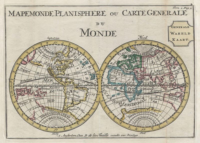
| Mapemonde Planisphere ou Carte Generale du Monde - Generale Wareld Kaart.
( |
||||||||||||||||||||
|---|---|---|---|---|---|---|---|---|---|---|---|---|---|---|---|---|---|---|---|---|
| Artist |
artist QS:P170,Q25930316 |
|||||||||||||||||||
| Title |
Mapemonde Planisphere ou Carte Generale du Monde - Generale Wareld Kaart. |
|||||||||||||||||||
| Description |
English: A very scarce later, c. 1706, edition of a map of the world on a hemisphere projection first issued by Daniel de La Feuille in 1702. Much of the coastlines are plotted conjecturally at best. Features a massive California in Island form. Further north the American Northwest Coast is blank suggesting though not specifically detailing a Northwest Passage. Antarctica (Terres Antarctiques) seems to merge into the incomplete line representing New Zealand’s eastern coast. The coastline of eastern Australia is largely indistinct and undefined. In Asia the Great Wall of China is drawn in and Japan is labeled though only loosely defined. In Polynesia, the Solomon Islands appear but no other island groups are identified. This map was originally prepared for inclusion as chart no. 2 in the 1702 edition of De la Feuille's Atlas Portatif. This particular map is from the 1706 reissue as indicated by the addition of the Dutch “Generale Wareld Kaart.” to the title. |
|||||||||||||||||||
| Date |
1706 date QS:P571,+1706-00-00T00:00:00Z/9 |
|||||||||||||||||||
| Dimensions |
height: 6 in (15.2 cm); width: 8.5 in (21.5 cm) dimensions QS:P2048,6U218593 dimensions QS:P2049,8.5U218593 |
|||||||||||||||||||
| Accession number |
Geographicus link: Mapemonde-lafeuille-1706 |
|||||||||||||||||||
| Source/Photographer |
|
|||||||||||||||||||
| Permission (Reusing this file) |
|
|||||||||||||||||||
File history
Click on a date/time to view the file as it appeared at that time.
| Date/Time | Thumbnail | Dimensions | User | Comment | |
|---|---|---|---|---|---|
| current | 13:24, 24 March 2011 |  | 2,688 × 1,921 (783 KB) | BotMultichillT (talk | contribs) | {{subst:User:Multichill/Geographicus |link=http://www.geographicus.com/P/AntiqueMap/Mapemonde-lafeuille-1706 |product_name=1706 de La Feuille Map of the World on Hemisphere Projection |map_title=Mapemonde Planisphere ou Carte Generale du Monde - Generale |
You cannot overwrite this file.
File usage on Commons
The following page uses this file: