File:1581 Bunting clover leaf map-ar.png
Jump to navigation
Jump to search

Size of this preview: 762 × 600 pixels. Other resolutions: 305 × 240 pixels | 610 × 480 pixels | 976 × 768 pixels | 1,280 × 1,008 pixels | 2,560 × 2,015 pixels | 2,961 × 2,331 pixels.
Original file (2,961 × 2,331 pixels, file size: 13.19 MB, MIME type: image/png)
Captions
Captions
Add a one-line explanation of what this file represents
Summary[edit]
| Artist |
|
|||||||||||||||||||||||||
| Title |
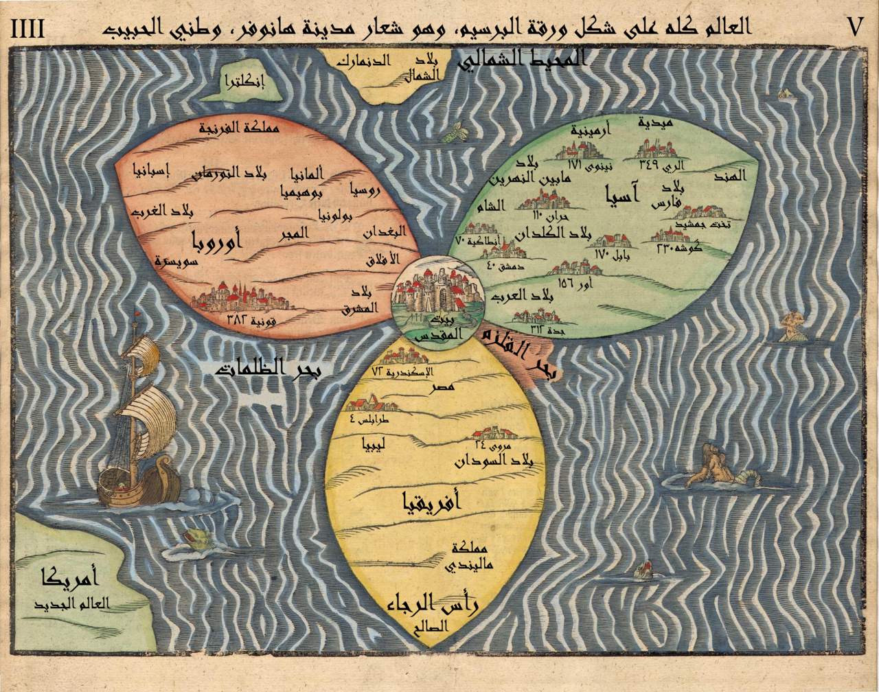
العربية: خارطة للعالم على شكل ورقة البرسيم (قارَّات العالم القديم الثلاثة وهي أوروبا وآسيا وأفريقيا)، وتظهر مدينة القدس في الوسط، كما تمَّت الإشارة إلى بريطانيا العظمى، واسكندنافيا وأمريكا / العالم الجديد. الصفحة 4f. من مؤلَّف مطبوع في مغدبيرغ. Deutsch: Die gantze Welt in einem Kleberblat / Welches ist der Stadt Hannover meines lieben Vaterlandes Wapen English: The entire world in the shape of a clover-leaf, which is the emblem of the city of Hannover, my beloved homeland |
|||||||||||||||||||||||||
| Description |
Stylized world map in the shape of a clover-leaf (the three classical continents of Europe, Asia, Africa), with Jerusalem at the center, with additional indication of Great Britain, Scandinavia and America / the New World. Page 4f. of Die eigentliche und warhafftige gestalt der Erden und des Meers (1581), printed in Magdeburg. |
|||||||||||||||||||||||||
| Date | 1581 | |||||||||||||||||||||||||
| Medium | woodcut print | |||||||||||||||||||||||||
| Source/Photographer |
Derived from  Penyulap (derivative) باسم (derivative) باسم Penyulap (derivative) باسم (derivative) باسم |
|||||||||||||||||||||||||
| Other versions | derivative work: 1581_Bunting_clover_leaf_map.jpg: Humus sapiens (original upload) | |||||||||||||||||||||||||
| This is a retouched picture, which means that it has been digitally altered from its original version. Modifications: Translated to Arabic - عُرِّبت. The original can be viewed here: 1581 Bunting clover leaf map.jpg:
|
Licensing[edit]
|
This is a faithful photographic reproduction of a two-dimensional, public domain work of art. The work of art itself is in the public domain for the following reason:
The official position taken by the Wikimedia Foundation is that "faithful reproductions of two-dimensional public domain works of art are public domain".
This photographic reproduction is therefore also considered to be in the public domain in the United States. In other jurisdictions, re-use of this content may be restricted; see Reuse of PD-Art photographs for details. | ||||
Original upload log[edit]
This image is a derivative work of the following images: Derivative works of this file: خارطة العالم تتوسطها مدينة القدس.jpg
- File:1581_Bunting_clover_leaf_map.jpg licensed with PD-Art, PD-Art-100
- 2006-11-30T05:48:16Z Tarawneh 4441x3496 (15053069 Bytes) higher res.
- 2006-04-12T08:52:05Z Humus sapiens 1736x1472 (972644 Bytes) == Summary == Bünting clover leaf map. A woodcut made in 1581 in Magdeburg. Jerusalem is in the center, surrounded by Europe, Asia and Africa. Source: [http://www.helmink.com/Antique_Map_Bunting_World/] [[Category:Jerusal
Uploaded with derivativeFX
}}
File history
Click on a date/time to view the file as it appeared at that time.
| Date/Time | Thumbnail | Dimensions | User | Comment | |
|---|---|---|---|---|---|
| current | 21:31, 26 February 2013 | | 2,961 × 2,331 (13.19 MB) | باسم (talk | contribs) | == {{int:filedesc}} == {{Information |Description={{ar|خارطة للعالم على شكل ورقة البرسيم (قارَّات العالم القديم الثلاثة وهي أوروبا وآسيا وأفريقيا)، وتظهر مدينة ال... |
You cannot overwrite this file.
File usage on Commons
The following page uses this file:
File usage on other wikis
The following other wikis use this file:
- Usage on ar.wikipedia.org