File:12 Mile Road Bridge Ceresco.jpg
Jump to navigation
Jump to search

Size of this preview: 800 × 281 pixels. Other resolutions: 320 × 112 pixels | 640 × 224 pixels | 1,024 × 359 pixels | 2,512 × 881 pixels.
Original file (2,512 × 881 pixels, file size: 543 KB, MIME type: image/jpeg)
Captions
Captions
Add a one-line explanation of what this file represents
Summary[edit]
| Description |
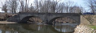
English: The 12 Mile Road Bridge across the Kalamazoo River in Ceresco, MI. The bridge is listed on the National Register of Historic Places. |
| Date | |
| Source | Own work |
| Author | kennethaw88 |
| Camera location | | View this and other nearby images on: OpenStreetMap |
|---|
|
This is an image of a place or building that is listed on the National Register of Historic Places in the United States of America. Its reference number is 99001610. |
Licensing[edit]
I, the copyright holder of this work, hereby publish it under the following license:
This file is licensed under the Creative Commons Attribution 4.0 International license.
- You are free:
- to share – to copy, distribute and transmit the work
- to remix – to adapt the work
- Under the following conditions:
- attribution – You must give appropriate credit, provide a link to the license, and indicate if changes were made. You may do so in any reasonable manner, but not in any way that suggests the licensor endorses you or your use.
File history
Click on a date/time to view the file as it appeared at that time.
| Date/Time | Thumbnail | Dimensions | User | Comment | |
|---|---|---|---|---|---|
| current | 23:48, 26 March 2016 | 2,512 × 881 (543 KB) | Kennethaw88 (talk | contribs) | User created page with UploadWizard |
You cannot overwrite this file.
File usage on Commons
There are no pages that use this file.
File usage on other wikis
The following other wikis use this file:
- Usage on de.wikipedia.org
- Usage on en.wikipedia.org
- Usage on www.wikidata.org
Metadata
Categories:
- National Register of Historic Places in Calhoun County, Michigan
- Bridges on the National Register of Historic Places in Michigan
- Concrete bridges in the United States
- Arch bridges in Michigan
- Bridges in the United States less than 0.1 kilometers
- Bridges completed in 1920
- Built in Michigan in 1920
- Bridges over the Kalamazoo River
- March 2016 in Michigan