File:01-Mitte Abstand-Strecke nur mit Zirkel.svg
Jump to navigation
Jump to search

Size of this PNG preview of this SVG file: 627 × 600 pixels. Other resolutions: 251 × 240 pixels | 502 × 480 pixels | 803 × 768 pixels | 1,070 × 1,024 pixels | 2,141 × 2,048 pixels | 833 × 797 pixels.
Original file (SVG file, nominally 833 × 797 pixels, file size: 123 KB)
Captions
Captions
Add a one-line explanation of what this file represents
Summary
[edit]
| Description |
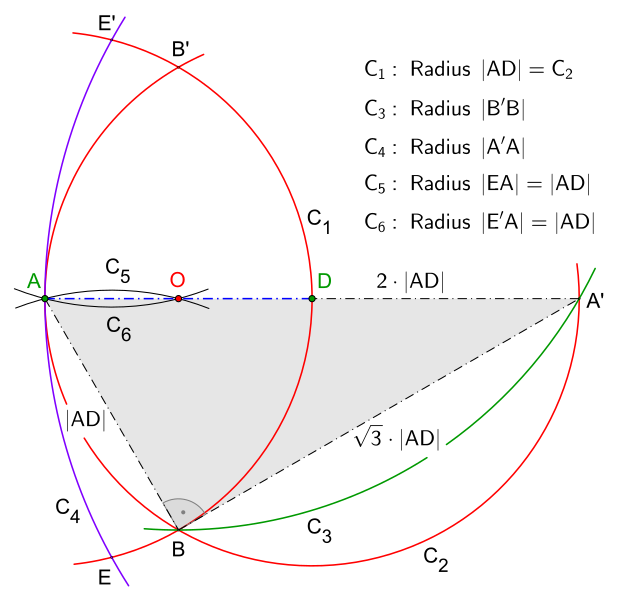
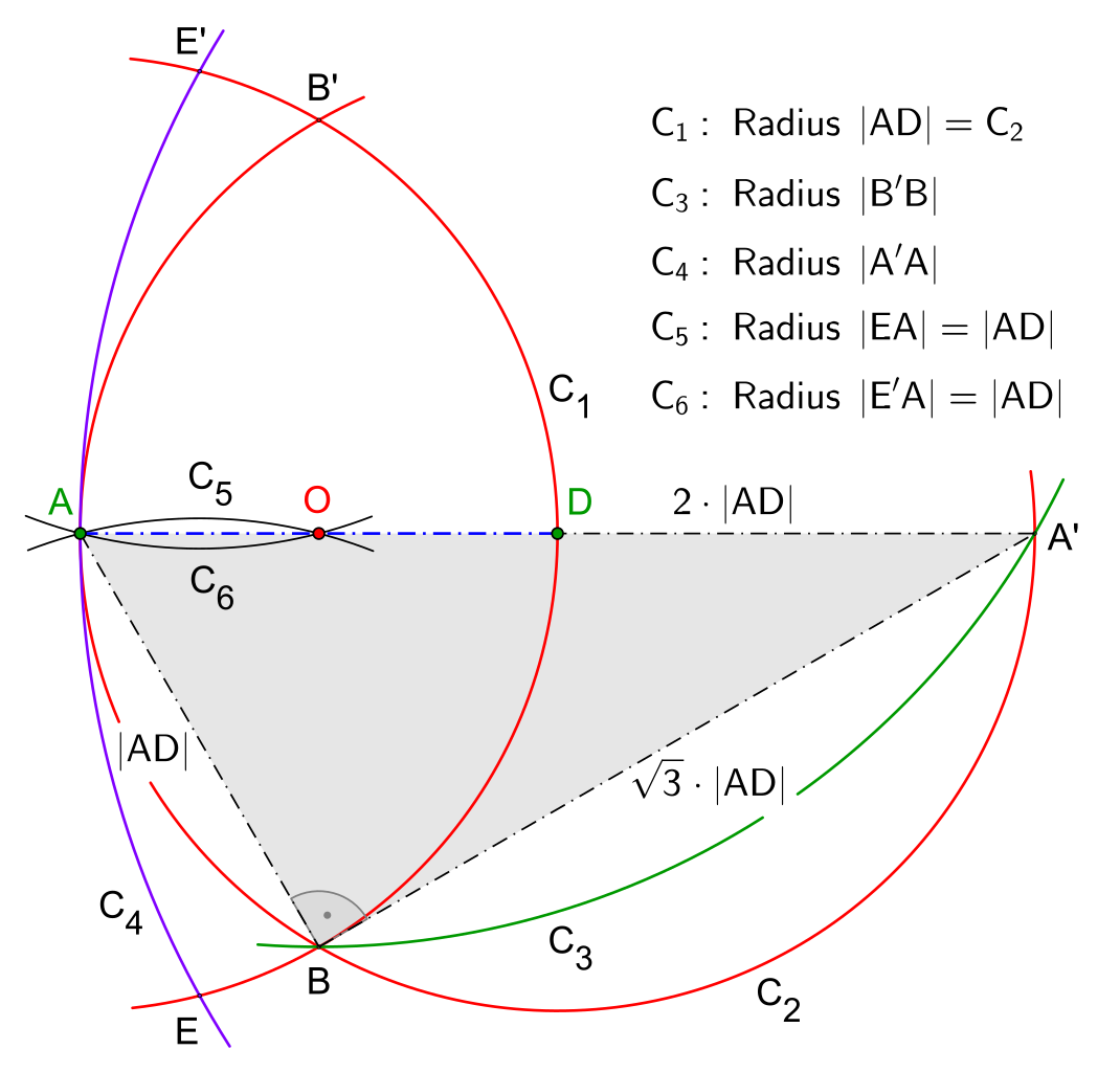
Deutsch: Konstruktion der Mitte von einem Abstand oder einer Strecke nur mit einem Zirkel
English: Construction the center of a distance or of a segment only with a compass |
| Date | |
| Source | Own work |
| Author | Petrus3743 |
| Other versions |
 Construction the center of a distance or of a segment only with a compass, according Mascheroni, animation |
| SVG development |
Licensing
[edit]
I, the copyright holder of this work, hereby publish it under the following license:
This file is licensed under the Creative Commons Attribution-Share Alike 4.0 International license.
- You are free:
- to share – to copy, distribute and transmit the work
- to remix – to adapt the work
- Under the following conditions:
- attribution – You must give appropriate credit, provide a link to the license, and indicate if changes were made. You may do so in any reasonable manner, but not in any way that suggests the licensor endorses you or your use.
- share alike – If you remix, transform, or build upon the material, you must distribute your contributions under the same or compatible license as the original.
File history
Click on a date/time to view the file as it appeared at that time.
| Date/Time | Thumbnail | Dimensions | User | Comment | |
|---|---|---|---|---|---|
| current | 08:16, 13 September 2016 | | 833 × 797 (123 KB) | Petrus3743 (talk | contribs) | Zeichen für rechten Winkel ergänzt |
| 08:05, 13 September 2016 |  | 833 × 797 (122 KB) | Petrus3743 (talk | contribs) | Postionen der Seitenbezeichnungen geändert | |
| 06:52, 13 September 2016 |  | 833 × 797 (121 KB) | Petrus3743 (talk | contribs) | Dreieck alsr Hinweis für Strecke 2AD | |
| 09:02, 28 August 2016 |  | 833 × 797 (109 KB) | Petrus3743 (talk | contribs) | Kreis entfernt | |
| 08:27, 28 August 2016 |  | 833 × 797 (109 KB) | Petrus3743 (talk | contribs) | Punktebezeichnung angepasst | |
| 21:35, 27 August 2016 |  | 833 × 797 (109 KB) | Petrus3743 (talk | contribs) | Punktbezeichnung korrigiert | |
| 21:18, 27 August 2016 |  | 833 × 797 (110 KB) | Petrus3743 (talk | contribs) | Konstruktion vereinfacht | |
| 20:53, 27 August 2016 |  | 833 × 797 (114 KB) | Petrus3743 (talk | contribs) | Punktbezeichnung ausgerichtet | |
| 19:13, 27 August 2016 |  | 833 × 797 (114 KB) | Petrus3743 (talk | contribs) | Schriftfarbe geändert | |
| 19:11, 27 August 2016 |  | 833 × 797 (114 KB) | Petrus3743 (talk | contribs) | User created page with UploadWizard |
You cannot overwrite this file.
File usage on Commons
The following page uses this file:
File usage on other wikis
The following other wikis use this file:
- Usage on en.wikipedia.org