File:00 Wartburg Burgplan.JPG
Jump to navigation
Jump to search

Size of this preview: 297 × 598 pixels. Other resolutions: 119 × 240 pixels | 238 × 480 pixels | 926 × 1,865 pixels.
Original file (926 × 1,865 pixels, file size: 1.86 MB, MIME type: image/jpeg)
Captions
Captions
Add a one-line explanation of what this file represents
Summary
[edit]
| Description |
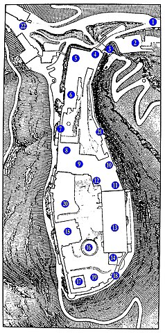
English: Map of the Wartburg castle. |
| Date | |
| Source | Own work |
| Author | Metilsteiner |
Informations-Grafik auf der Burg. (1) Zufahrt, (2) Schanze, (3) Zugbrücke, (4) Torhaus, (5) Ritterhaus, (6) Vogtei und erster Burghof, (7) Margarethengang, (8) Dirnitz, (9) (inneres) Torhaus, (10) Neue Kemenate, (11) Treppenhaus, (12) Bergfried, (13) Palas, (14) Ritterbad, (15) Gadem, (16) zweiter Burghof mit Zisterne, (17) Südturm, (18) südliche Wehrmauer, (19) Küchengarten, (20) Kommandantengarten, (21) Elisabethengang, (22) Hotel auf der Wartburg
Licensing
[edit]
I, the copyright holder of this work, hereby publish it under the following license:
This file is licensed under the Creative Commons Attribution 3.0 Unported license.
- You are free:
- to share – to copy, distribute and transmit the work
- to remix – to adapt the work
- Under the following conditions:
- attribution – You must give appropriate credit, provide a link to the license, and indicate if changes were made. You may do so in any reasonable manner, but not in any way that suggests the licensor endorses you or your use.
File history
Click on a date/time to view the file as it appeared at that time.
| Date/Time | Thumbnail | Dimensions | User | Comment | |
|---|---|---|---|---|---|
| current | 18:16, 18 May 2010 | | 926 × 1,865 (1.86 MB) | Metilsteiner (talk | contribs) | {{Information |Description={{en|1=Map of the Wartburg castle.}} |Source={{own}} |Author=Metilsteiner |Date=2010-05-17 |Permission= |other_versions= }} Informations-Grafik auf der Burg. Category:Wartburg 2010 |
You cannot overwrite this file.
File usage on Commons
There are no pages that use this file.
File usage on other wikis
The following other wikis use this file:
- Usage on ar.wikipedia.org
- Usage on de.wikipedia.org
- Usage on en.wikipedia.org
- Usage on gl.wikipedia.org
- Usage on it.wikipedia.org
- Usage on mt.wikipedia.org
- Usage on nl.wikipedia.org
- Usage on sl.wikipedia.org
- Usage on uz.wikipedia.org