File:002osd000000008u00089000.jpg
Jump to navigation
Jump to search

Size of this preview: 800 × 534 pixels. Other resolutions: 320 × 214 pixels | 640 × 428 pixels | 1,024 × 684 pixels | 1,280 × 855 pixels | 2,560 × 1,710 pixels | 4,000 × 2,672 pixels.
Original file (4,000 × 2,672 pixels, file size: 3.13 MB, MIME type: image/jpeg)
Captions
Captions
Add a one-line explanation of what this file represents
Summary[edit]
| Title |
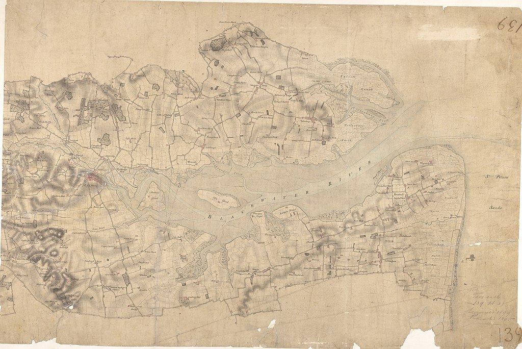
Ordnance Surveyor Drawing of Maldon (OSD 139 serial 89) |
||||
| Description |
This drawing covers the area surrounding the Blackwater River. Pencil lines radiate from trigonometrical stations: notable fixed locations from which angular measurements were taken. Rays emanating from Iltney near the centre of the map, on the south bank of the river, have been used to plot the relative position of the Chigborough Road on the opposite bank. The marshes around Tollesbury Fleet are indicated by irregular intersecting lines. |
||||
| Map legend | Ordnance Surveyor Drawing of Maldon (OSD 139 serial 89) [North: 51.803533197387, South: 51.6646427569254, East: 0.974833216088248, West: 0.614344392412753] | ||||
| Source |
|
||||
| Creator |
unattributed |
||||
| Credit line | British Library | ||||
| Permission (Reusing this file) |
|
||||
| Geotemporal data | |||||
| Date depicted | |||||
| Scale | 2 : 1 Mile (1 : 31680) | ||||
| Bounding box |
|
||||
| Georeferencing | If inappropriate please set warp_status = skip to hide. | ||||
| Archival data | |||||
| Collection | |||||
| Accession number |
OSD 139 serial 89 |
||||
| Dimensions | 87 x 54 cm | ||||
| Medium | Pen and ink on paper | ||||
| Notes | Please note that the British Library provides these digital files "as-is"; materials will not be rephotographed under this programme. If resupply of files is required, the requestor will be required to purchase them at the standard rate. | ||||

_(St_Edwards_Crown).svg)


Licensing[edit]
File history
Click on a date/time to view the file as it appeared at that time.
| Date/Time | Thumbnail | Dimensions | User | Comment | |
|---|---|---|---|---|---|
| current | 11:31, 6 August 2021 | | 4,000 × 2,672 (3.13 MB) | FilipeMSB (talk | contribs) | pattypan 20.04 |
You cannot overwrite this file.
File usage on Commons
There are no pages that use this file.