File:000 Bonnaskenplatz-Schmellwitz Anger map and signalling.png
Jump to navigation
Jump to search

Size of this preview: 110 × 596 pixels. Other resolution: 273 × 1,478 pixels.
Original file (273 × 1,478 pixels, file size: 262 KB, MIME type: image/png)
Captions
Captions
Add a one-line explanation of what this file represents
| Description |
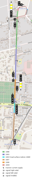
English: Map showing the Bonnaskenplatz <-> Schmellwitz Anger section of the Cottbus tram network. Also indicated are traction current feeders, the signalling and track conditions (date of construction or last modernization where applicable).
Map data © OpenStreetMap contributors. See the project's website for details. |
|||
| Date | ||||
| Source | http://www.openstreetmap.org/ | |||
| Author | OpenStreetMap contributors and Trio3D | |||
| Permission (Reusing this file) |
This file is licensed under the Creative Commons Attribution-Share Alike 2.0 Generic license.
|
File history
Click on a date/time to view the file as it appeared at that time.
| Date/Time | Thumbnail | Dimensions | User | Comment | |
|---|---|---|---|---|---|
| current | 11:07, 26 July 2016 | 273 × 1,478 (262 KB) | Trio3D (talk | contribs) | Updated thanks to new information. | |
| 14:11, 15 June 2016 | 273 × 1,434 (261 KB) | Trio3D (talk | contribs) | Track diagrams usually show signals in the correct perspective. | ||
| 15:58, 9 May 2016 | 274 × 1,344 (258 KB) | Trio3D (talk | contribs) | Corrected an error. | ||
| 17:31, 30 April 2016 | 274 × 1,344 (259 KB) | Trio3D (talk | contribs) | {{Information |Description ={{en|1=Map showing the Bonnaskenplatz <-> Schmellwitz Anger section of the Cottbus tram network. Also indicated are traction current feeders, the signalling and track conditions. However, date of construction resp. modern... |
You cannot overwrite this file.
File usage on Commons
The following 21 pages use this file:
- User:AbdealiJKTravis/logs/newimages/20160726
- User:Chumwa/OgreBot/Potential transport maps/2016 April 21-30
- User:Chumwa/OgreBot/Potential transport maps/2016 July 21-31
- User:Chumwa/OgreBot/Potential transport maps/2016 June 11-20
- User:Chumwa/OgreBot/Potential transport maps/2016 May 1-10
- User:Chumwa/OgreBot/Public transport information/2016 April 21-30
- User:Chumwa/OgreBot/Public transport information/2016 July 21-31
- User:Chumwa/OgreBot/Public transport information/2016 June 11-20
- User:Chumwa/OgreBot/Public transport information/2016 May 1-10
- User:Chumwa/OgreBot/Transport Maps/2016 April 21-30
- User:Chumwa/OgreBot/Transport Maps/2016 July 21-31
- User:Chumwa/OgreBot/Transport Maps/2016 June 11-20
- User:Chumwa/OgreBot/Transport Maps/2016 May 1-10
- User:Chumwa/OgreBot/Travel and communication maps/2016 April 21-30
- User:Chumwa/OgreBot/Travel and communication maps/2016 July 21-31
- User:Chumwa/OgreBot/Travel and communication maps/2016 June 11-20
- User:Chumwa/OgreBot/Travel and communication maps/2016 May 1-10
- User:Indeedous/Recent Uploads/Cottbus/2016
- User:Nordlicht8/Rail Germany/2016 April 21-30
- User:Nordlicht8/Rail Germany/2016 June 11-20
- User:Nordlicht8/Rail Germany/2016 May 1-10