File:0000-Royal Observatory-Observatory-s.jpg
Jump to navigation
Jump to search

Size of this preview: 770 × 599 pixels. Other resolutions: 308 × 240 pixels | 617 × 480 pixels | 987 × 768 pixels | 1,280 × 997 pixels | 1,499 × 1,167 pixels.
Original file (1,499 × 1,167 pixels, file size: 823 KB, MIME type: image/jpeg)
Captions
Captions
Add a one-line explanation of what this file represents
Summary
[edit]
| Description |
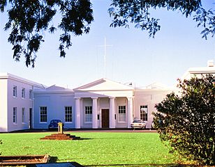
Afrikaans: Suidaansig op die hoofgebou van die Koninklike Sterrewag aan die Kaap die Goeie Hoop, geleë in Observatory, Kaapstad. Bouwerk het in 1825 begin, met John Skirrow as boukontrakteur, en teen 1829 is gereelde sterrekundige waarnemings uitgevoer. Die gebou het aanvanklik teleskoopkoepels op albei suidvleuels gehad. Die geriewe is sedert 1972 ingelyf by die Suid-Afrikaanse Astronomiese Observatorium (SAAO), en die teleskope word tans by Sutherland in die Noord-Kaap gehuisves.
English: Southern aspect of the main building of the (former) Royal Observatory, Cape of Good Hope, situated in Observatory, Cape Town. Construction commenced in 1825, with John Skirrow as contractor, and by 1829 regular astronomical observations were being carried out. The building initially had telescope domes on each of the south wings. These facilities were amalgamated with those of the South African Astronomical Observatory (SAAO) in 1972, and the telescopes are currently housed at Sutherland in the Northern Cape.
|
||
| Date | |||
| Source | Own work | ||
| Author | Janek Szymanowski |
| Camera location | | View this and other nearby images on: OpenStreetMap |
|---|
Licensing
[edit]
I, the copyright holder of this work, hereby publish it under the following license:
This file is licensed under the Creative Commons Attribution-Share Alike 3.0 Unported license.
- You are free:
- to share – to copy, distribute and transmit the work
- to remix – to adapt the work
- Under the following conditions:
- attribution – You must give appropriate credit, provide a link to the license, and indicate if changes were made. You may do so in any reasonable manner, but not in any way that suggests the licensor endorses you or your use.
- share alike – If you remix, transform, or build upon the material, you must distribute your contributions under the same or compatible license as the original.

|
This image was uploaded as part of Wiki Loves Monuments 2013.
|
 |
File history
Click on a date/time to view the file as it appeared at that time.
| Date/Time | Thumbnail | Dimensions | User | Comment | |
|---|---|---|---|---|---|
| current | 14:18, 25 September 2013 | | 1,499 × 1,167 (823 KB) | Janek Szymanowski (talk | contribs) | User created page with UploadWizard |
You cannot overwrite this file.
File usage on Commons
There are no pages that use this file.
File usage on other wikis
The following other wikis use this file:
- Usage on en.wikipedia.org