File:(Map of Washington D.C. showing wood, concrete, and stone street pavements). LOC 87695618.jpg
Jump to navigation
Jump to search

Size of this preview: 757 × 600 pixels. Other resolutions: 303 × 240 pixels | 606 × 480 pixels | 970 × 768 pixels | 1,280 × 1,014 pixels | 2,560 × 2,028 pixels | 9,622 × 7,622 pixels.
Original file (9,622 × 7,622 pixels, file size: 9.95 MB, MIME type: image/jpeg)
Captions
Captions
Add a one-line explanation of what this file represents
Summary[edit]
| Description |
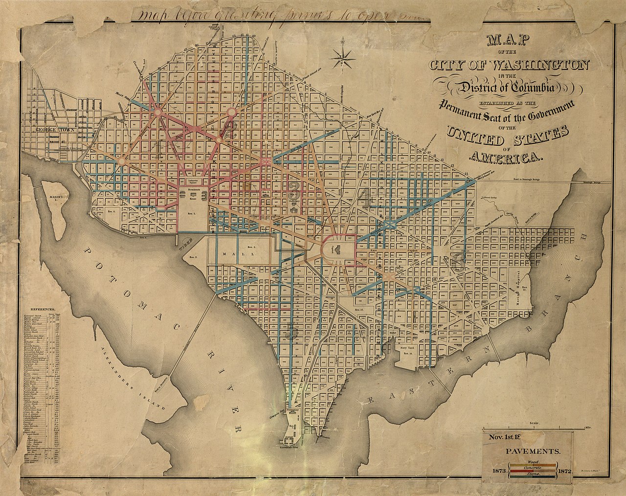
English: Also shows block and ward numbers. Hand col. to show street paving types for 1872 and 1873. At head of legend: Nov. 1st 18[missing] pavements. Base map title: Map of the city of Washington in the District of Columbia : established as the permanent seat of the government of the United States of America / W.J. Stone sc. Wash'n. Available also through the Library of Congress Web site as a raster image. Annotated in ink in upper margin: [1st word missing] map before granting permits to open stree[ts?]. Legend on separate sheet affixed to recto. Includes index to points of interest. LC copy soiled, brittle, lacking sections along margins, and mounted on cloth backing. Vault DCP |
||
| Title | [Map of Washington D.C. showing wood, concrete, and stone street pavements]. | ||
| Shelf ID | G3851.P2 1873 .M3 | ||
| Date | |||
| Source | https://www.loc.gov/item/87695618/ | ||
| Author | Stone, William James | ||
| Permission (Reusing this file) |
|
||
| Other versions |
|
||
| Location | United States · Washington D.C. · District Of Columbia · Washington | ||
| Part of | American Memory · Cities And Towns · Catalog · Geography And Map Division | ||
| Subject | Washington (D.C.) · Washington · United States · Maps · District Of Columbia · Pavements |


._LOC_87695618.jpg&action=edit§ion=1)
Licensing[edit]
._LOC_87695618.jpg&action=edit§ion=2)
|
This is a faithful photographic reproduction of a two-dimensional, public domain work of art. The work of art itself is in the public domain for the following reason:
The official position taken by the Wikimedia Foundation is that "faithful reproductions of two-dimensional public domain works of art are public domain".
This photographic reproduction is therefore also considered to be in the public domain in the United States. In other jurisdictions, re-use of this content may be restricted; see Reuse of PD-Art photographs for details. | ||||
File history
Click on a date/time to view the file as it appeared at that time.
| Date/Time | Thumbnail | Dimensions | User | Comment | |
|---|---|---|---|---|---|
| current | 06:12, 3 June 2018 | | 9,622 × 7,622 (9.95 MB) | Fæ (talk | contribs) | LOC Maps https://www.loc.gov/item/87695618/ #3177 |
You cannot overwrite this file.
File usage on Commons
The following page uses this file:
._LOC_87695618.jpg&oldid=734036950)