File:مدينة العبور و امتدادها obour and its extension.png
Jump to navigation
Jump to search

Size of this preview: 800 × 454 pixels. Other resolutions: 320 × 182 pixels | 640 × 364 pixels | 1,024 × 582 pixels | 1,280 × 727 pixels | 2,401 × 1,364 pixels.
Original file (2,401 × 1,364 pixels, file size: 297 KB, MIME type: image/png)
Captions
Captions
Add a one-line explanation of what this file represents
Summary
[edit]
| Description |
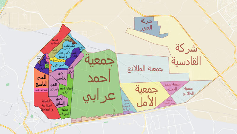
English: Map of obour city (in Black writing) and its extension (in red writing)
مفتاح مدينة العبور:- الأزرق الغامق: إسكان فيلات فاخر البنفسجي: إسكان فيلات الأزرق الفاتح: مناطق إسكان متوسط البرتقالي: مناطق عمارات فاخر الذهبي: مناطق إسكان شباب بني: مناطق الإسكان القومي أصفر: مركز المدينة الأخضر: مناطق خضراء الوردي: مناطق جامعات الأحمر: مناطق صناعية |
| Date | |
| Source |
{{own وزارة الإسكان و المجتمعات العمرانية، هيئة المجتمعات العمرانية الجديدة}} |
| Author | RETFrog |
Licensing
[edit]
I, the copyright holder of this work, hereby publish it under the following license:
This file is licensed under the Creative Commons Attribution-Share Alike 4.0 International license.
- You are free:
- to share – to copy, distribute and transmit the work
- to remix – to adapt the work
- Under the following conditions:
- attribution – You must give appropriate credit, provide a link to the license, and indicate if changes were made. You may do so in any reasonable manner, but not in any way that suggests the licensor endorses you or your use.
- share alike – If you remix, transform, or build upon the material, you must distribute your contributions under the same or compatible license as the original.
File history
Click on a date/time to view the file as it appeared at that time.
| Date/Time | Thumbnail | Dimensions | User | Comment | |
|---|---|---|---|---|---|
| current | 17:00, 14 December 2022 | | 2,401 × 1,364 (297 KB) | HassanRETF (talk | contribs) | Uploaded own work with UploadWizard |
You cannot overwrite this file.
File usage on Commons
There are no pages that use this file.
File usage on other wikis
The following other wikis use this file:
- Usage on ar.wikipedia.org