File:خريطة عثمانية قديمة تبين ان الموصل جزء من العراق في عهد الأتابكة.png
Jump to navigation
Jump to search

Size of this preview: 403 × 599 pixels. Other resolutions: 161 × 240 pixels | 323 × 480 pixels | 817 × 1,215 pixels.
Original file (817 × 1,215 pixels, file size: 1.07 MB, MIME type: image/png)
Captions
Captions
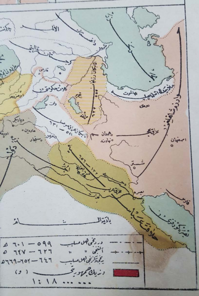
Ottoman map displaying the Mosul region as part of Iraq during the Atabeg era (published in 1908)
Summary[edit]
| Description |
English: Ottoman map displaying the Mosul region as part of Iraq during the Atabeg era (published in 1908) |
| Date | |
| Source | محمد أشرف, 1908, أطليس وعثماين عمومي تاريخ مخترص |
| Author | محمد أشرف |
Licensing[edit]
This file is licensed under the Creative Commons Attribution-Share Alike 4.0 International license.
- You are free:
- to share – to copy, distribute and transmit the work
- to remix – to adapt the work
- Under the following conditions:
- attribution – You must give appropriate credit, provide a link to the license, and indicate if changes were made. You may do so in any reasonable manner, but not in any way that suggests the licensor endorses you or your use.
- share alike – If you remix, transform, or build upon the material, you must distribute your contributions under the same or compatible license as the original.
File history
Click on a date/time to view the file as it appeared at that time.
| Date/Time | Thumbnail | Dimensions | User | Comment | |
|---|---|---|---|---|---|
| current | 09:20, 10 March 2021 | | 817 × 1,215 (1.07 MB) | Helphelper1 (talk | contribs) | Uploaded a work by محمد أشرف from محمد أشرف, 1908, أطليس وعثماين عمومي تاريخ مخترص with UploadWizard |
You cannot overwrite this file.
File usage on Commons
There are no pages that use this file.
File usage on other wikis
The following other wikis use this file:
- Usage on ar.wikipedia.org