File:אהרן בן חיים. 1836. מפת גבולי ארץ הצבי. ורשה 1883.jpg
Jump to navigation
Jump to search

Size of this preview: 731 × 599 pixels. Other resolutions: 293 × 240 pixels | 585 × 480 pixels | 937 × 768 pixels | 1,249 × 1,024 pixels | 2,312 × 1,896 pixels.
Original file (2,312 × 1,896 pixels, file size: 1.72 MB, MIME type: image/jpeg)
Captions
Captions
Add a one-line explanation of what this file represents
Summary[edit]
| Description |
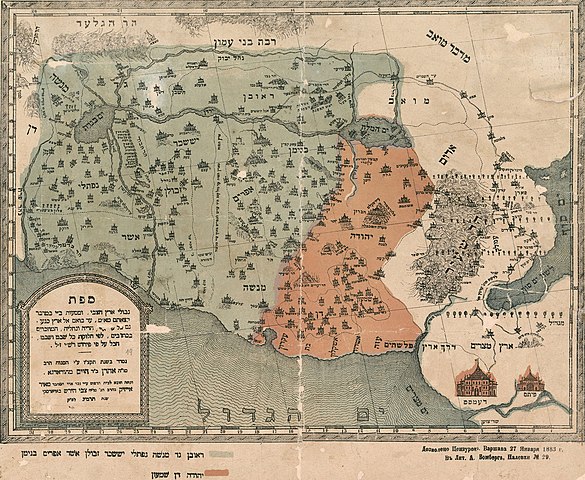
עברית: אהרון בן חיים מגרודנו. פרסם בשנת 1836 "ספר מורה דרך", מדריך לארץ ישראל שבו מודפסת מפה ציורית בשם: "מפת גבולי ארץ הצבי ומסעות בני ישראל במדבר בצאתם מארץ מצרים עד בואם אל ארץ כנען גם כל ערי א"י, הריה ונחליה המוזכרים בכתובים, לפי חלוקת כל שבט ושבט, הכל על פי פירוש רש"י ז"ל". המפה צוירה והוצאה לאור יותר מאוחר ע"י נכד אחיו מאיר אייזיק בויארסקי. ורשה שנת תרמ"ג 1883 |
| Date |
(ה'תקצ"ו)
|
| Source | Jewish National & University Library, The Eran Laor Cartographic Collection |
| Author | Aaron ben Hayyim of Grodno (אהרן בן חיים, גרודנו). died before 1883. |
| Other versions |
 |
Licensing[edit]
|
This is a faithful photographic reproduction of a two-dimensional, public domain work of art. The work of art itself is in the public domain for the following reason:
The official position taken by the Wikimedia Foundation is that "faithful reproductions of two-dimensional public domain works of art are public domain".
This photographic reproduction is therefore also considered to be in the public domain in the United States. In other jurisdictions, re-use of this content may be restricted; see Reuse of PD-Art photographs for details. | ||||
| Annotations | This image is annotated: View the annotations at Commons |
File history
Click on a date/time to view the file as it appeared at that time.
| Date/Time | Thumbnail | Dimensions | User | Comment | |
|---|---|---|---|---|---|
| current | 01:22, 29 March 2011 | | 2,312 × 1,896 (1.72 MB) | Geagea (talk | contribs) | Remove borders |
| 01:01, 29 March 2011 |  | 2,707 × 2,280 (1.72 MB) | Geagea (talk | contribs) | == {{int:filedesc}} == == {{int:filedesc}} == {{Information |Description={{he|1=אהרון בן חיים מגרודנו. פרסם בשנת 1836 "ספר מורה דרך", מדריך לארץ ישראל שבו מודפסת מפה ציורית בשם: "מ |
You cannot overwrite this file.
File usage on Commons
The following 2 pages use this file:
File usage on other wikis
The following other wikis use this file:
- Usage on es.wikipedia.org
- Usage on he.wikipedia.org