File:Франко-мексиканская война.svg
From Wikimedia Commons, the free media repository
Jump to navigation
Jump to search

Size of this PNG preview of this SVG file: 706 × 599 pixels. Other resolutions: 283 × 240 pixels | 565 × 480 pixels | 905 × 768 pixels | 1,206 × 1,024 pixels | 2,412 × 2,048 pixels | 1,060 × 900 pixels.
Original file (SVG file, nominally 1,060 × 900 pixels, file size: 62 KB)
File information
Structured data
Captions
Captions
Add a one-line explanation of what this file represents
Summary[edit]
| DescriptionФранко-мексиканская война.svg |
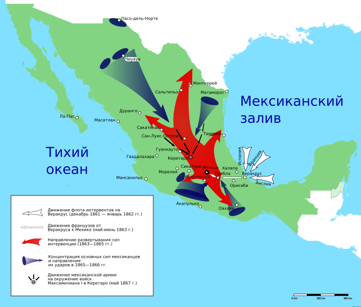
English: French intervention in Mexico, image based on map from book of A. Belenky "Разгром мексиканским народом иностранной интервенции", 1959 (original source: russian 1949 year edition of Henry B. Parkes "A History of Mexico") Русский: Французская интервенция в Мексику, при создании использовалась карта из книги А. Беленького "Разгром мексиканским народом иностранной интервенции", М.:1959 (первоисточник: Г. Паркс "История Мексики", М.:1949) |
|||||
| Date | (UTC) | |||||
| Source |
This file was derived from: Mapa de Mexico 1864.PNG: |
|||||
| Author |
|
|||||
| SVG development InfoField |
|
Licensing[edit]
I, the copyright holder of this work, hereby publish it under the following license:
| Public domainPublic domainfalsefalse |
| I, the copyright holder of this work, release this work into the public domain. This applies worldwide. In some countries this may not be legally possible; if so: I grant anyone the right to use this work for any purpose, without any conditions, unless such conditions are required by law. |
Original upload log[edit]
This image is a derivative work of the following images:
- File:Mapa_de_Mexico_1864.PNG licensed with PD-self
- 2011-09-21T04:41:07Z Hpav7 1669x1518 (100154 Bytes) ajustes
- 2010-01-14T05:52:05Z Hpav7 1669x1518 (100256 Bytes) Correccion de frontera entre Sonora y Baja California
- 2010-01-08T11:40:36Z Hpav7 1669x1518 (100253 Bytes) {{Information |Description={{en|1=Map of Mexico in 1864 after the restoration of the state of Nuevo Leon.}} {{es|1=Mapa de Mexico en 1864 despues de la restauracion del estado de Nuevo Leon.}} |Source={{own}} |Author=[[User:H
Uploaded with derivativeFX
File history
Click on a date/time to view the file as it appeared at that time.
| Date/Time | Thumbnail | Dimensions | User | Comment | |
|---|---|---|---|---|---|
| current | 19:04, 14 November 2018 |  | 1,060 × 900 (62 KB) | JoKalliauer (talk | contribs) | phab:T36947 text kerning |
| 20:13, 21 March 2012 |  | 1,060 × 900 (130 KB) | Yourist2 (talk | contribs) | correction | |
| 20:08, 21 March 2012 |  | 1,060 × 900 (130 KB) | Yourist2 (talk | contribs) | correction | |
| 19:47, 21 March 2012 |  | 1,060 × 900 (130 KB) | Yourist2 (talk | contribs) | correction | |
| 19:45, 21 March 2012 |  | 1,060 × 900 (130 KB) | Yourist2 (talk | contribs) | Изменены очертания элементов | |
| 12:26, 21 March 2012 |  | 1,060 × 900 (132 KB) | Yourist2 (talk | contribs) | scale | |
| 12:10, 21 March 2012 |  | 1,060 × 900 (128 KB) | Yourist2 (talk | contribs) | == {{int:filedesc}} == {{Information |Description={{en|1=Map of Mexico in 1864 after the restoration of the state of Nuevo Leon.}} {{es|1=Mapa de Mexico en 1864 despues de la restauracion del estado de Nuevo Leon.}} |Source={{Derived from|Mapa_de_Mexic... |
You cannot overwrite this file.
File usage on Commons
The following 2 pages use this file:
File usage on other wikis
The following other wikis use this file:
- Usage on hy.wikipedia.org
- Usage on lv.wikipedia.org
- Usage on ru.wikipedia.org
Metadata
This file contains additional information such as Exif metadata which may have been added by the digital camera, scanner, or software program used to create or digitize it. If the file has been modified from its original state, some details such as the timestamp may not fully reflect those of the original file. The timestamp is only as accurate as the clock in the camera, and it may be completely wrong.
| Width | 1060.1 |
|---|---|
| Height | 900.35 |
