File:Світло-тіньове супутникове зображення мікрорельєфу місцевості.jpg
Original file (1,130 × 839 pixels, file size: 714 KB, MIME type: image/jpeg)
Captions
Captions
Summary[edit]
| Description |
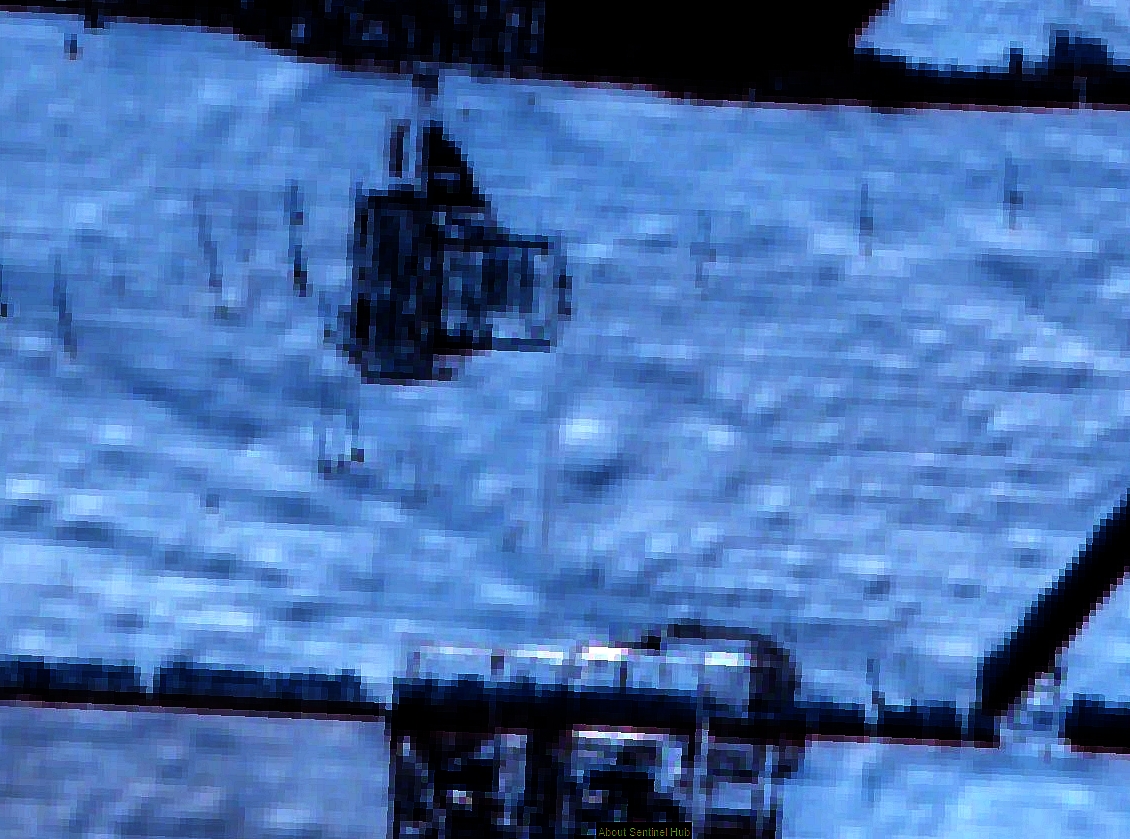
Українська: У центрі супутникового зображення місцевості вкритої шаром снігу, при низькому куті сонячного освітлення, простежується ізольована кругла западина що оточена дотичним підняттям рельєфу, яке ймовірно є ознакою невідомого метеоритного кратера із залишками кратерного валу.
English: In the center of the satellite image of the area covered with a layer of snow, at a low angle of sunlight, there is an isolated round depression surrounded by a tangential relief, which is probably a sign of an unknown meteorite crater with the remains of a crater shaft. English: Observation of light and shadow satellite image of terrain microrelief as one of the methods of searching for unknown meteorite craters |
| Date | |
| Source | Own work |
| Author | Латуха Валерій Іванович |
| Camera location | | View this and other nearby images on: OpenStreetMap |
|---|
Licensing[edit]

|
This image contains data from a satellite in the Copernicus Programme, such as Sentinel-1, Sentinel-2 or Sentinel-3. Attribution is required when using this image.
Attribution: Contains modified Copernicus Sentinel data 2020
The use of Copernicus Sentinel Data is regulated under EU law (Commission Delegated Regulation (EU) No 1159/2013 and Regulation (EU) No 377/2014). Relevant excerpts:
Free access shall be given to GMES dedicated data [...] made available through GMES dissemination platforms [...].
Access to GMES dedicated data [...] shall be given for the purpose of the following use in so far as it is lawful:
GMES dedicated data [...] may be used worldwide without limitations in time.
GMES dedicated data and GMES service information are provided to users without any express or implied warranty, including as regards quality and suitability for any purpose. |
- You are free:
- to share – to copy, distribute and transmit the work
- to remix – to adapt the work
- Under the following conditions:
- attribution – You must give appropriate credit, provide a link to the license, and indicate if changes were made. You may do so in any reasonable manner, but not in any way that suggests the licensor endorses you or your use.
- share alike – If you remix, transform, or build upon the material, you must distribute your contributions under the same or compatible license as the original.
| This image was uploaded as part of Science Photo Competition 2020 in Ukraine. |
Licensing[edit]
- You are free:
- to share – to copy, distribute and transmit the work
- to remix – to adapt the work
- Under the following conditions:
- attribution – You must give appropriate credit, provide a link to the license, and indicate if changes were made. You may do so in any reasonable manner, but not in any way that suggests the licensor endorses you or your use.
| This image was uploaded as part of Science Photo Competition 2020 in Ukraine. |
File history
Click on a date/time to view the file as it appeared at that time.
| Date/Time | Thumbnail | Dimensions | User | Comment | |
|---|---|---|---|---|---|
| current | 03:48, 14 November 2020 | | 1,130 × 839 (714 KB) | Latuha1 (talk | contribs) | Uploaded own work with UploadWizard |
You cannot overwrite this file.
File usage on Commons
There are no pages that use this file.