File:Île du Levant. Vue satellite. SPOT 1272.jpg
Jump to navigation
Jump to search
No higher resolution available.
Île_du_Levant._Vue_satellite._SPOT_1272.jpg (270 × 227 pixels, file size: 13 KB, MIME type: image/jpeg)
Captions
Captions
Add a one-line explanation of what this file represents
Summary
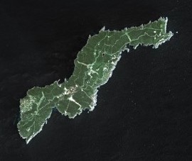
[edit]| Description | Levant island by SPOT Satellite. The small isle at the north-east is l'Esquadillon |
| Date | |
| Source | http://gallery.spotimage.com/poduct_info.php?products_id=1272 |
| Author | Cnes - Spot Image |
| Permission (Reusing this file) |
This file is licensed under the Creative Commons Attribution-Share Alike 3.0 Unported license.
|
| Other versions |

File history
Click on a date/time to view the file as it appeared at that time.
| Date/Time | Thumbnail | Dimensions | User | Comment | |
|---|---|---|---|---|---|
| current | 15:31, 21 October 2017 | | 270 × 227 (13 KB) | 6PO (talk | contribs) | File:Port-Cros SPOT 1272.jpg cropped 46 % horizontally and 55 % vertically using CropTool with precise mode. |
You cannot overwrite this file.
File usage on Commons
The following 2 pages use this file:
- File:Port-Cros SPOT 1272.jpg
- File:Port-Cros SPOT 1272 (cropped).jpg (file redirect)
.jpg&redirect=no)