File:Île Tromelin.png
Jump to navigation
Jump to search
No higher resolution available.
Île_Tromelin.png (326 × 350 pixels, file size: 6 KB, MIME type: image/png)
Captions
Captions
Add a one-line explanation of what this file represents
Summary
[edit]
| Description |
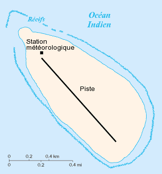
Français : Carte de l'île Tromelin
Fond de carte de la CIA francisé, source : http://www.cia.gov/cia/publications/factbook/maps/te-map.gif Données de août 2005. |
| Source | CIA World Fact Book |
| Author | CIA |
Licensing
[edit]
| This image is a work of a Central Intelligence Agency employee, taken or made as part of that person's official duties. As a Work of the United States Government, this image or media is in the public domain in the United States.
|

|
Original upload log
[edit]
The original description page was here. All following user names refer to fr.wikipedia.
- 2005-09-10 18:19 Idarvol 326×350× (5906 bytes) L'île Tromelin
File history
Click on a date/time to view the file as it appeared at that time.
| Date/Time | Thumbnail | Dimensions | User | Comment | |
|---|---|---|---|---|---|
| current | 21:43, 16 October 2009 | | 326 × 350 (6 KB) | Korribot (talk | contribs) | {{BotMoveToCommons|fr.wikipedia|year={{subst:CURRENTYEAR}}|month={{subst:CURRENTMONTHNAME}}|day={{subst:CURRENTDAY}}}} {{Information |Description={{fr|Carte de l'île Tromelin Fond de carte de la CIA francisé, source : http://www.cia.gov/cia/publicati |
You cannot overwrite this file.
File usage on Commons
The following page uses this file:
File usage on other wikis
The following other wikis use this file:
- Usage on br.wikipedia.org