File:Électorat de Mayence.png
Jump to navigation
Jump to search

Size of this preview: 468 × 600 pixels. Other resolutions: 187 × 240 pixels | 500 × 641 pixels.
Original file (500 × 641 pixels, file size: 57 KB, MIME type: image/png)
Captions
Captions
Add a one-line explanation of what this file represents
| Description |
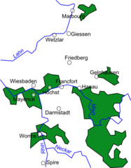
Français : Carte de l'électorat de Mayence et de l'évêché de Worms vers 1648.
English: Map of the Electorate of Mainz and the Prince-Bishopric of Worms around 1648. |
| Date | (UTC) |
| Source | |
| Author |
|
I, the copyright holder of this work, hereby publish it under the following licenses:
This file is licensed under the Creative Commons Attribution 2.5 Generic license.
- You are free:
- to share – to copy, distribute and transmit the work
- to remix – to adapt the work
- Under the following conditions:
- attribution – You must give appropriate credit, provide a link to the license, and indicate if changes were made. You may do so in any reasonable manner, but not in any way that suggests the licensor endorses you or your use.
| This file is licensed under the Creative Commons Attribution-Share Alike 3.0 Unported license. | ||
| ||
| This licensing tag was added to this file as part of the GFDL licensing update. |

|
Permission is granted to copy, distribute and/or modify this document under the terms of the GNU Free Documentation License, Version 1.2 or any later version published by the Free Software Foundation; with no Invariant Sections, no Front-Cover Texts, and no Back-Cover Texts. A copy of the license is included in the section entitled GNU Free Documentation License. |
You may select the license of your choice.
Original upload log[edit]
This image is a derivative work of the following images:
- File:HRR__1648.png licensed with Cc-by-2.5, Cc-by-sa-3.0-migrated, GFDL
- 2009-10-16T10:54:33Z Ziegelbrenner 2362x2190 (2839844 Bytes) 200-10-16
- 2009-09-25T11:56:24Z Ziegelbrenner 2362x2190 (2839832 Bytes) 2009-09-25
- 2009-03-31T10:54:40Z Ziegelbrenner 2362x2189 (2720889 Bytes) 2009-03-31
- 2008-12-16T14:50:22Z Ziegelbrenner 2362x2189 (3266496 Bytes)
- 2008-05-16T12:48:23Z Ziegelbrenner 2362x2189 (2741304 Bytes)
- 2008-04-28T13:03:37Z Ziegelbrenner 2362x2190 (2721876 Bytes)
- 2008-03-17T12:02:52Z Ziegelbrenner 2362x2189 (2714494 Bytes)
- 2008-03-10T15:16:25Z Ziegelbrenner 2362x2189 (2707226 Bytes)
- 2008-03-10T15:11:24Z Ziegelbrenner 4842x4488 (3851086 Bytes)
- 2008-02-25T15:08:54Z Ziegelbrenner 2362x2189 (2707851 Bytes)
- 2008-02-13T18:00:21Z Ziegelbrenner 2362x2190 (2679061 Bytes)
- 2008-02-12T10:50:18Z Ziegelbrenner 2362x2189 (2678534 Bytes)
- 2008-02-11T12:10:15Z Ziegelbrenner 2362x2189 (2675834 Bytes) == Beschreibung == {{Information |Description=Karte des Heiligen Römischen Reiches 1648 / Map of Holy Roman Empire 1648 |Source=own drawing/Source of Information: Putzger – Historischer Weltatlas, 89. Auflage, 1965 |Date=2
Uploaded with derivativeFX
File history
Click on a date/time to view the file as it appeared at that time.
| Date/Time | Thumbnail | Dimensions | User | Comment | |
|---|---|---|---|---|---|
| current | 20:27, 18 February 2015 | | 500 × 641 (57 KB) | RokerHRO (talk | contribs) | optipng -o7 -i0 → 23.63% decrease |
| 17:52, 18 January 2010 |  | 500 × 641 (74 KB) | BrightRaven (talk | contribs) | Better version | |
| 16:55, 17 January 2010 |  | 500 × 685 (79 KB) | BrightRaven (talk | contribs) | {{Information |Description=Carte de l'électorate de Mayence vers 1648. Map of the Electorate of Mainz around 1648. |Source=*File:HRR__1648.png |Date=2010-01-17 16:54 (UTC) |Author=*File:HRR__1648.png: [[:de:Benutzer:ziegelbrenner|ziegelbrenne |
You cannot overwrite this file.
File usage on Commons
The following 4 pages use this file:
File usage on other wikis
The following other wikis use this file:
- Usage on az.wikipedia.org
- Usage on be.wikipedia.org
- Usage on bg.wikipedia.org
- Usage on ca.wikipedia.org
- Usage on cs.wikipedia.org
- Usage on el.wikipedia.org
- Usage on en.wikipedia.org
- Usage on es.wikipedia.org
- Usage on et.wikipedia.org
- Usage on fi.wikipedia.org
- Usage on fr.wikipedia.org
- Usage on hu.wikipedia.org
- Usage on ko.wikipedia.org
- Usage on mk.wikipedia.org
- Usage on pl.wikipedia.org
- Usage on www.wikidata.org
- Usage on zh.wikipedia.org