File:'Donkey Rock', Broughton-in-Furness - geograph.org.uk - 50803.jpg
Jump to navigation
Jump to search
No higher resolution available.
'Donkey_Rock',_Broughton-in-Furness_-_geograph.org.uk_-_50803.jpg (640 × 480 pixels, file size: 184 KB, MIME type: image/jpeg)
Captions
Captions
Add a one-line explanation of what this file represents
Summary[edit]
| Description |
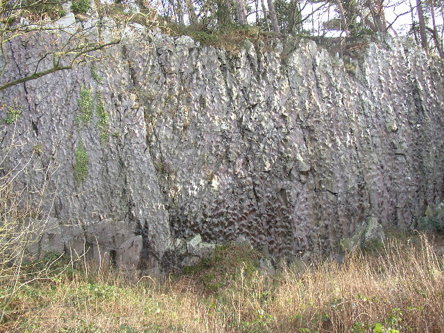
English: 'Donkey Rock', Broughton-in-Furness. By the roadside at SD210867, Bush Green Quarry has a cliff-face 70m across and 10m high that shows 'sole structures' in the almost vertically bedded turbidite sandstones and mudstones (Coniston Grits) of Silurian age, about 400 million years old. These are knobbly lumps on the surface of the rock, formed by the deposition of hard material on the sea-bed by deep-water currents, and there are more than 1800 of them, mainly types known as flute and load casts, covering six bedding planes (see www.ougsnw.org.uk/photo_gallery/Geoscenes/ Foxfield.html). Further information see Moseley 1978 Geology of the Lake District, p 143, Yorkshire Geological Society. |
| Date | |
| Source | From geograph.org.uk |
| Author | Humphrey Bolton |
| Attribution (required by the license) | Humphrey Bolton / 'Donkey Rock', Broughton-in-Furness / |
| Object location | | View this and other nearby images on: OpenStreetMap |
|---|
_&language=en)
Licensing[edit]

|
This image was taken from the Geograph project collection. See this photograph's page on the Geograph website for the photographer's contact details. The copyright on this image is owned by Humphrey Bolton and is licensed for reuse under the Creative Commons Attribution-ShareAlike 2.0 license.
|
This file is licensed under the Creative Commons Attribution-Share Alike 2.0 Generic license.
Attribution: Humphrey Bolton
- You are free:
- to share – to copy, distribute and transmit the work
- to remix – to adapt the work
- Under the following conditions:
- attribution – You must give appropriate credit, provide a link to the license, and indicate if changes were made. You may do so in any reasonable manner, but not in any way that suggests the licensor endorses you or your use.
- share alike – If you remix, transform, or build upon the material, you must distribute your contributions under the same or compatible license as the original.
File history
Click on a date/time to view the file as it appeared at that time.
| Date/Time | Thumbnail | Dimensions | User | Comment | |
|---|---|---|---|---|---|
| current | 12:40, 30 January 2010 | | 640 × 480 (184 KB) | GeographBot (talk | contribs) | == {{int:filedesc}} == {{Information |description={{en|1='Donkey Rock', Broughton-in-Furness. By the roadside at SD210867, Bush Green Quarry has a cliff-face 70m across and 10m high that shows 'sole structures' in the almost vertically bedded turbidite sa |
You cannot overwrite this file.
File usage on Commons
There are no pages that use this file.
File usage on other wikis
The following other wikis use this file:
- Usage on en.wikipedia.org