Commons:Featured picture candidates/File:Flag-map of the world.svg
Jump to navigation
Jump to search

File:Flag-map of the world.svg, featured[edit]
Voting period is over. Please don't add any new votes.Voting period ends on 23 Dec 2009 at 05:34:21 (UTC)
Visit the nomination page to add or modify image notes.

 Info created by Transparent 6lue - uploaded by Transparent 6lue - nominated by Transparent 6lue -- Transparent 6lue (talk) 05:34, 14 December 2009 (UTC)
 Support -- Transparent 6lue (talk) 05:34, 14 December 2009 (UTC)
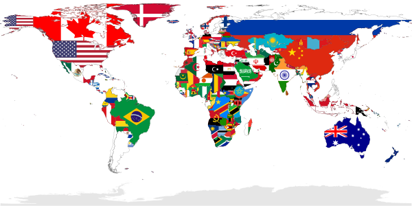
 Comment I am not so sure Greenland is correct. /Pieter Kuiper (talk) 07:37, 14 December 2009 (UTC)
- Support This is a great idea, and beautifully executed. Correlations that I wasn't aware of until now can be seen at a glance, e.g. that most African countries have green as the predominant color in their flags. Greenland is formally a part of the Kingdom of Denmark, so it looks OK to me. True, they have their own flag, but so does Alaska which is also shown with the flag of the "parent state". -- JovanCormac 10:07, 14 December 2009 (UTC)
- Although I agree that the Greenlandic flag shouln't replace the Danish, Alaska's relation to the United States is to my knowledge no different from that of any of the other 50 states - Greenland, however, is far more autonomous than any other area (possibly except for the Faeroes) under the Danish crown. --Aqwis (talk) 10:41, 14 December 2009 (UTC)
- I have only shown the national flags here, regardless of how autonomous any of their subdivisions are. --Transparent 6lue (talk) 23:22, 14 December 2009 (UTC)
- Comment, I would suggest replacing the Norwegian flag on Svalbard with a uniform red colour. --Aqwis (talk) 10:45, 14 December 2009 (UTC)
- Although this would certainly make it look a lot better, keep in mind that it could be confused with the red of Denmark/Greenland/Faroe Islands. --Transparent 6lue (talk) 23:22, 14 December 2009 (UTC)
- The status of Svalbard is special - not really Norway. /Pieter Kuiper (talk) 09:36, 15 December 2009 (UTC)
- Still, Norway's surely the most accurate national flag that you could apply to it. Transparent 6lue (talk) 23:37, 15 December 2009 (UTC)
- Svalbard is a part of the Kingdom of Norway, see en:Politics_of_Svalbard#Spitsbergen_Treaty. --Kjetil_r 20:15, 18 December 2009 (UTC)
- The status of Svalbard is special - not really Norway. /Pieter Kuiper (talk) 09:36, 15 December 2009 (UTC)
- Comment I would prefer the sea to be non-white, because it merges with some of the flags. Perhaps a very pale blue? --99of9 (talk) 12:12, 14 December 2009 (UTC)
- The black outlines should not make the ocean a problem. However, if anyone wants to change the ocean to very pale blue (or perhaps very pale grey), someone else will have to do it because the finished file makes my computer lag too much. --Transparent 6lue (talk) 23:22, 14 December 2009 (UTC)
- The black outlines aren't enough for my eyes. But I'm an idiot... the sea is transparent in the svg, so I can have whatever background I like - no need for a change. Support --99of9 (talk) 00:18, 15 December 2009 (UTC)
- The black outlines aren't enough for my eyes. But I'm an idiot... the sea is transparent in the svg, so I can have whatever background I like - no need for a change.
- Support - Clever idea and quality implementation.
PS could you make the Finnish flag slightly smaller, the same size as the Swedish flag.--MattiPaavola (talk) 18:15, 14 December 2009 (UTC)
- The Finnish flag is bigger than the Swedish one because if you look up the proportions, the Finnish cross is much more thicker. The shapes of the countries are also a factor in how they turned out. --Transparent 6lue (talk) 23:22, 14 December 2009 (UTC)
- Sorry, my mistake. After checking the sources, I have to shamely admit that I didn't know my and my neighbor's flags. :-) Thanks for the explanation. --MattiPaavola (talk) 23:46, 14 December 2009 (UTC)
- Support Whatever the background colour, it's simply great. Sarcastic ShockwaveLover (talk) 09:14, 15 December 2009 (UTC)
- Support --Econt (talk) 10:54, 15 December 2009 (UTC)
 Neutral I'm not convinced by this idea --Leafnode✉ 11:25, 15 December 2009 (UTC)
 Oppose - the map is inconsistent. It shows Alaska and Greenland the same way, it shows Kosovo but doesn't show Palestine, flag proportions are strictly kept for Finland and Greece but not for Japan and South Korea, no clear criteria over which island nations were included and why etc. So even though the idea is fine there is still a lot of work to do.--Avala (talk) 12:52, 15 December 2009 (UTC)
- I'm not sure what you mean by Alaska and Greenland being "the same way", but I'll answer the other points. I have updated the map to reflect a new criteria, which is the UN member countries
plus the Republic of China. As for the proportions, I decided that the designs where the field was distinctly divided into several areas should be kept as close to the original as possible. On the other hand, I decided that the symbol-on-a-background designs could be resized if it would help recognisability. I have added all islands now. Transparent 6lue (talk) 23:37, 15 December 2009 (UTC)
- Oppose I agree with Avala. What are the criterias about selected countries? --.dsm. 18:58, 15 December 2009 (UTC)
- The UN member countries
plus the Republic of China. Transparent 6lue (talk) 02:01, 17 December 2009 (UTC)- Is Western Sahara the UN member state? Why would you add the Republic of China which has less recognitions than Western Sahara and also why not add Palestine which has more reconigtions than any other state? It's obvious there is no criteria for this map.--Avala (talk) 13:18, 17 December 2009 (UTC)
- Thanks for informing me of the situation, I wasn't sure about how recognised certain places are. In any case, I have taken Takabeg's advice and now the map shows only the UN member states. Also, I'm still confused about your statement that "It shows Alaska and Greenland the same way", could you please clarify what this means and what you would recommend instead? Transparent 6lue (talk) 00:59, 18 December 2009 (UTC)
- I mean that the status of Alaska and Greenland is not the same. Though this is the matter not so important and can be viewed differently so I will change my vote to Support now that the criteria is set.--Avala (talk) 16:59, 21 December 2009 (UTC)
- I mean that the status of Alaska and Greenland is not the same. Though this is the matter not so important and can be viewed differently so I will change my vote to
- Thanks for informing me of the situation, I wasn't sure about how recognised certain places are. In any case, I have taken Takabeg's advice and now the map shows only the UN member states. Also, I'm still confused about your statement that "It shows Alaska and Greenland the same way", could you please clarify what this means and what you would recommend instead? Transparent 6lue (talk) 00:59, 18 December 2009 (UTC)
- Is Western Sahara the UN member state? Why would you add the Republic of China which has less recognitions than Western Sahara and also why not add Palestine which has more reconigtions than any other state? It's obvious there is no criteria for this map.--Avala (talk) 13:18, 17 December 2009 (UTC)
![]() Comment - I recommend you change as the map of Member States of the United Nations. Takabeg (talk) 15:32, 17 December 2009 (UTC)
Comment - I recommend you change as the map of Member States of the United Nations. Takabeg (talk) 15:32, 17 December 2009 (UTC)
- Comment If his is the map of Member States of the United Nations, the name should be "Flag-map of the United Nations member states". Because all recognized states of the world aren't here. --.dsm. 14:55, 19 December 2009 (UTC)
- Oppose Conditional support - When did Morocco annex Western Sahara ? When did People's Republic of China annex Republic of China ? I think they must be shown in white (blank map). Takabeg (talk) 08:07, 22 December 2009 (UTC)
- The UN's official position (to the best of my knowledge) is that Taiwan is part of the People's Republic of China, and that Western Sahara is part of Morocco. Also, if I changed those two to white, it'd start up arguments and debates about which places should be white and which ones shouldn't (for example Palestine, Kosovo etc.). So, although there is no perfect solution to the problem of "which countries should be shown on this map, and how?", the current version seems to provoke the least arguing so it's probably the closest to "perfect" that it can get. Feel free to suggest any more improvements, though. Transparent 6lue (talk) 00:38, 23 December 2009 (UTC)
- Please look at the map of UN. Takabeg (talk) 05:07, 23 December 2009 (UTC)
- Thanks for pointing that out. I've changed Western Sahara to light grey now, especially as it is a Non-Self-Governing Territory with no administration (source). As for Taiwan, I'm sure that it's correct the way it is, but don't hesitate to correct me if necessary. Transparent 6lue (talk) 06:04, 23 December 2009 (UTC)
- Support - A great idea--Pianoplonkers (talk) 10:39, 22 December 2009 (UTC)
- Support – nice idea, well done. --Kjetil_r 10:51, 22 December 2009 (UTC)
Confirmed results:
Result: 10 support, 1 oppose, 1 neutral → featured. /George Chernilevsky talk 09:41, 23 December 2009 (UTC)
This image will be added to the FP gallery: Non-photographic media/Maps