Rosegg
Jump to navigation
Jump to search
Deutsch: Rosegg ist eine Gemeinde im österreichischem Bundesland Kärnten.
Furlan: Rosegg al è un comun logât tal stât federâl austriac dale Carintie.
Русский: Розег — посёлок в Австрии, в федеральной земле Каринтия.
municipality in Villach-Land District, Carinthia, Austria   | |||||
| Upload media | |||||
| Instance of |
| ||||
|---|---|---|---|---|---|
| Location | Villach-Land District, Carinthia, Austria | ||||
| Population |
| ||||
| Area |
| ||||
| Elevation above sea level |
| ||||
| official website | |||||
 | |||||
Berg (Gora)
[edit]Bergl (Gora)
[edit]Buchheim (Podhum)
[edit]Dolintschach (Dolinčiče)
[edit]Drau (Na Dravi)
[edit]-
 English:
Dam of the old riverbed as part of the hydroelectric power plant at the DravaDeutsch:
Talsperre des alten Flussbetts als Teil des Wasserkraftwerkes der Drau

Duel (Dole)
[edit]Emmersdorf (Tmara vas)
[edit]-
 English:
East viewDeutsch:
Ost-Ansicht -
 English:
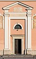
Subsidiary church Saint LawrenceDeutsch:
Filialkirche Heiliger Laurentius


Frög (Breg)
[edit]-
 English:
Road bridge across the new riverbed of the DravaDeutsch:
Straßenbrücke über das neue Flussbett der Drau -
 English:
The new riverbed of the DravaDeutsch:
Das neue Flussbett der Drau -
 English:
The new riverbed of the DravaDeutsch:
Das neue Flussbett der Drau -
 English:
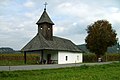
ChapelDeutsch:
Kapelle -
 English:
ChapelDeutsch:
Kapelle -
 English:
Celtic demonstration cairnDeutsch:
Keltlisches Hügelgrab (Rekonstruktion für Schauzwecke)


Frojach (Broje)
[edit]-
 English:
Road bridge across the new riverbed of the DravaDeutsch:
Bundesstraßenbrücke über das neue Flussbett der Drau -
 English:
Pillar wayside shrineDeutsch:
Pfeilerbildstock -
 English:
Fresco on the south side of the pillar wayside shrineDeutsch:
Südliches Nischenfresko im Pfeilerbildstock -
 English:
Fresco on the east side of the pillar wayside shrineDeutsch:
Östliches Nischenfresko im Pfeilerbildstock -
 English:
Fresco on the north side of the pillar wayside shrineDeutsch:
Nördliches Nischenfresko im Pfeilerbildstock -
 English:
Fresco on the west side of the pillar wayside shrineDeutsch:
Westliches Nischenfresko im Pfeilerbildstock


Kleinberg (Mala gora)
[edit]Obergoritschach (Zgornje Goriče)
[edit]Pirk (Brezje)
[edit]Raun (Ravne)
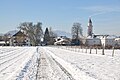
[edit]Rosegg (Rožek)
[edit]-
 English:
City limit signDeutsch:
Ortsschild

Getreidegasse
[edit]#2: Rectory | Nr. 2: Pfarrhof
[edit]-
 English:
Eastern viewDeutsch:
Ost-Ansicht -
 English:
Eastern viewDeutsch:
Ost-Ansicht -
 English:
Southsoutheastern viewDeutsch:
SSO-Ansicht -
 English:
Southeastern viewDeutsch:
SO-Ansicht -
 English:
Southeastern viewDeutsch:
SO-Ansicht -
 English:
Southeastern viewDeutsch:
SO-Ansicht


Mautweg
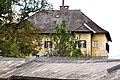
[edit]No. 7: Residential buildings | Nr. 7: Wohnhäuser
[edit]-
 English:
Southwestern viewDeutsch:
SW-Ansicht

Gedenktafel Kärntner Abwehrkampf 1918-1920
[edit]-
 English:
Eastern viewDeutsch:
Ost-Ansicht -
 English:
Eastern viewDeutsch:
Ost-Ansicht


Rosegger Straße
[edit]Drava bridge / Draubrücke
[edit]-
 English:
Southeastern viewDeutsch:
SO-Ansicht -
 English:
Eastern viewDeutsch:
Ost-Ansicht -
 English:
Southwestern viewDeutsch:
SW-Ansicht -
 English:
Southern viewDeutsch:
Süd-Ansicht -
 English:
Drava riverDeutsch:
Drau-Fluss


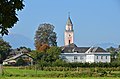
Parish church Saint Michael and cemetery | Pfarrkirche hl. Michael und Friedhof
[edit]-
 English:
Eastern viewDeutsch:
Ost-Ansicht -
 English:
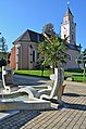
 Eastern view with municipal officeDeutsch: Ost-Ansicht mit Marktgemeindeamt
 -
 English:
Eastern view with municipal officeDeutsch:
Ost-Ansicht mit Marktgemeindeamt -
 English:
Eastern view with municipal officeDeutsch:
Ost-Ansicht mit Marktgemeindeamt -
 English:
Eastern view with municipal officeDeutsch:
Ost-Ansicht mit Marktgemeindeamt -
 English:
Eastern view with municipal officeDeutsch:
Ost-Ansicht mit Marktgemeindeamt -
 English:
Southwestern viewDeutsch:
SW-Ansicht -
 English:
Southwestern viewDeutsch:
SW-Ansicht -
 English:
Southwestern viewDeutsch:
SW-Ansicht -
 English: Southwestern viewDeutsch: SW-Ansicht
 -
 English:
Southwestern viewDeutsch:
SW-Ansicht -
 English:
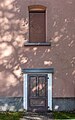
Western portalDeutsch:
West-Portal -
 English:
Western portalDeutsch:
West-Portal -
 English:
Western portalDeutsch:
West-Portal -
 English:
Western portalDeutsch:
West-Portal -
 English:
Western portalDeutsch:
West-Portal -
 English:
ApseDeutsch:
Chorschluss -
 English:
ApseDeutsch:
Chorschluss -
 English:
Northern sacristyDeutsch:
Nördlicher Sakristeianbau -
 English:
Northern sacristyDeutsch:
Nördlicher Sakristeianbau -
 English:
Northern sacristyDeutsch:
Nördlicher Sakristeianbau -
 English:
Northern sacristyDeutsch:
Nördlicher Sakristeianbau -
 English:
Crucifix at the northern sacristyDeutsch:
Kruzifix am nördlichen Sakristeianbau -
 English:
Northwestern viewDeutsch:
NW-Ansicht -
 English:
Northeastern viewDeutsch:
NO-Ansicht -
 English:
Southeastern viewDeutsch:
SO-Ansicht -
 English:
Steeple, southeastern viewDeutsch:
Kirchturm, SO-Ansicht -
 English:
InteriorDeutsch:
Inneres -
 English:
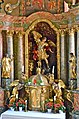
Main altarDeutsch:
Hauptaltar -
 English:
Main altarDeutsch:
Hauptaltar -
 English:
Sculpture of Saint Michael at the main altarDeutsch:
Skulptur des hl. Michael im Hauptaltar -
 English:
Sculpture of Saint Michael at the main altarDeutsch:
Skulptur des hl. Michael im Hauptaltar -

-
 English:
CrucifixDeutsch:
Kruzifix -
 English:
Side portalDeutsch:
Seiten-Portal -
 English:
EpitaphsDeutsch:
Epitaphe -
 English:
Seifrid Steirer zu TeschldorfDeutsch:
Epitaph für Seifrid Steirer zu Teschldorf -
 English:
Epitaph for Abraham HochenkircherDeutsch:
Epitaph für Abraham Hochenkircher -
 English:
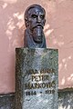
Monument of the academic painter Peter MarkovicDeutsch:
Denkmal des akademischen Malers Peter Markovic -
 English:
Monument of the academic painter Peter MarkovicDeutsch:
Denkmal des akademischen Malers Peter Markovic -
 English:
Monument of the academic painter Peter MarkovicDeutsch:
Denkmal des akademischen Malers Peter Markovic -
 English:
Monument of the academic painter Peter MarkovicDeutsch:
Denkmal des akademischen Malers Peter Markovic -
 English:
Monument of the academic painter Peter MarkovicDeutsch:
Denkmal des akademischen Malers Peter Markovic -
 English:
Monument of the academic painter Peter MarkovicDeutsch:
Denkmal des akademischen Malers Peter Markovic -
 English:
Monument of the academic painter Peter MarkovicDeutsch:
Denkmal des akademischen Malers Peter Markovic


Sattlerweg
[edit]#2: Zum Radhaus | Nr. 2: Zum Radhaus
[edit]-
 English:
Southwestern viewDeutsch:
SW-Ansicht

Schlossweg
[edit]War memorial | Kriegerdenkmal
[edit]-
 English:
Western viewDeutsch:
West-Ansicht -
 English:
Western viewDeutsch:
West-Ansicht


Schulweg
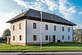
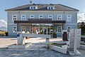
[edit]#2: Municipal office | Nr. 2: Marktgemeindeamt
[edit]-
 English:
Northwestern viewDeutsch:
NW-Ansicht -
 English:
Northwestern viewDeutsch:
NW-Ansicht -
 English:
North viewDeutsch:
Nord-Ansicht -
 English:
North viewDeutsch:
Nord-Ansicht -
 English:
PlaqueDeutsch:
Schild -
English:
Eastern viewDeutsch:
Ost-Ansicht -
 English:
FountainDeutsch:
Brunnen


Old and new castle | Altes und neues Schloss
[edit]-
 English:
Northern view at the castle ruin Old RoseggDeutsch:
Nord-Ansicht auf die Burgruine Altrosegg -
 English:
Northwestern view at the castle ruin Old RoseggDeutsch:
Blick aus Nordwest auf die Burgruine Altrosegg -
 English:
Northwestern view at the castle ruin Old RoseggDeutsch:
Blick aus Nordwest auf die Burgruine Altrosegg -
 English:
Red deer in the Rosegg Wildlife parkDeutsch:
Rotwild im Wildtierpark -
 English:
Peter Ritter von Bohr, former castle owner, doll at the expositionDeutsch:
Peter Ritter von Bohr, vormaliger Schloss-Besitzer, Wachsfigur der Ausstellung -
 English:
Peter Ritter von Bohr as counterfeiter, former castle owner, doll at the expositionDeutsch:
Peter Ritter von Bohr als Geldfälscher, vormaliger Schloss-Besitzer, Wachsfigur der Ausstellung -
 English:
Former farmhouse on the Rosegger Sreet #24Deutsch:
Ehemaliges Wirtschaftsgebäude an der Rosegger Straße 24 -
 English:
Hunter`s villa on the Muehlbacher Sreet #7Deutsch:
Jägerhaus an der Mühlbacher Straße 7 -
 English:
Hunter`s villa on the Muehlbacher Sreet #7Deutsch:
Jägerhaus an der Mühlbacher Straße 7 -
 English:
Hunter`s villa on the Muehlbacher Sreet #7Deutsch:
Jägerhaus an der Mühlbacher Straße 7 -
 English:
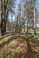
Castle alleyDeutsch:
Schlossallee -
 English:
Linden tree alley north of castle RoseggDeutsch:
Lindenbaum-Allee nördlich von Schloss Rosegg -
 English:
Linden tree alley north of castle RoseggDeutsch:
Lindenbaum-Allee nördlich von Schloss Rosegg -
 English:
Chestnut tree alley south of the castleDeutsch:
Kastanienbaum-Allee südlich des Schlosses -
 English:
Chestnut tree alley south of the castleDeutsch:
Kastanienbaum-Allee südlich des Schlosses -
 English:
Chestnut tree alley south of the castleDeutsch:
Kastanienbaum-Allee südlich des Schlosses -
 English:
South gate to the parkDeutsch:
Südliches Einfahrtstor -
 English:
South gate to the parkDeutsch:
Südliches Einfahrtstor -
 English:
Northern viewDeutsch:
Nord-Ansicht -
 English:
Northern viewDeutsch:
Nord-Ansicht -
 English:
Northern viewDeutsch:
Nord-Ansicht -
 English:
Northern gateDeutsch:
Nord-Tor -
 English:
Overdoor of the wrought iron gateDeutsch:
Supraporte am schmiedeeisernen Tor -
 English:
Westnorthwestern viewDeutsch:
WNW-Ansicht -
 English:
Side wingDeutsch:
Nebengebäude -
 English:
Northwestern viewDeutsch:
NW-Ansicht -
 English:
Northwestern viewDeutsch:
NW-Ansicht -
 English:
Northwestern viewDeutsch:
NW-Ansicht -
 English:
Northern entranceDeutsch:
Nord-Eingang -
 English:
Western viewDeutsch:
W-Ansicht -
 English:
Southern viewDeutsch:
Südansicht -
 English:
Southern viewDeutsch:
Südansicht -
 English:
Southern viewDeutsch:
Südansicht -
 English:
Southern viewDeutsch:
Südansicht -
 English:
Pediment, southern viewDeutsch:
Ziergiebel, Südseite -
 English:
Pediment, southern viewDeutsch:
Ziergiebel, Südseite -
 English:
Side building of the castleDeutsch:
Nebengebäude des Schlosses


Sankt Johann (Ščedem)
[edit]-
 English:
Subsidiary church Holy JohnDeutsch:
Filialkirche Heiliger Johann -
 English:
Subsidiary church Holy JohnDeutsch:
Filialkirche Heiliger Johann


Sankt Lambrecht (Semislavče)
[edit]-

-
 English:
Subsidiary church Holy AugustinusDeutsch:
Filialkirche Heiliger Augustin
.jpg)

Sankt Martin (Šmartin)
[edit]-
 English:
Subsidiary church Holy Bartholomew, south east viewDeutsch:
Filialkirche Heiliger Bartlmä, Südost-Ansicht -
 English:
Subsidiary church Holy Bartholomew, north viewDeutsch:
Filialkirche Heiliger Bartlmä, Nord-Ansicht


Untergoritschach (Spodnje Goriče)
[edit]Insignia and maps
[edit]-
 English:
Coat of Arms -
 English:
Position of Rosegg within Austria -
 English:
Position of Rosegg (6) within Villach-Land district

