File talk:Territorial Expansion of Russia.svg
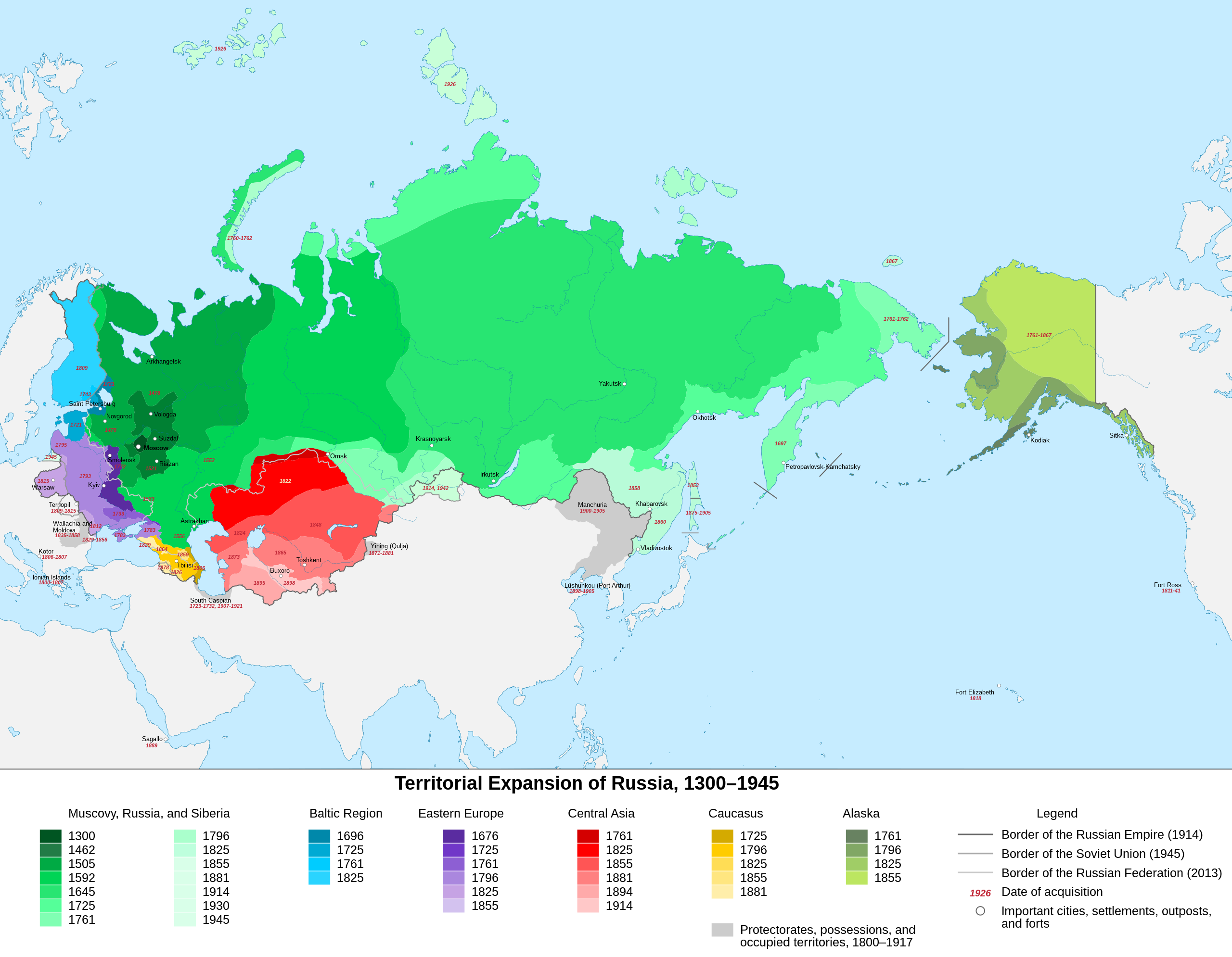
@Mzajac: This map contains inaccuracies in the dates of the annexation of lands. Smolensk and Kiev were finally annexed in 1654, not in 1772. Turkmenistan, except Merv, in 1881, and not in 1895, but Merv in 1885. Armenia was annexed in 1828, not in 1826. Bukhara became a vassal of Russia in 1868, not 1898. Каракорум (talk) 15:13, 22 February 2021 (UTC)
- I can change the labels, but at the moment I’m not set up to edit the colours or polygons. Anyway, substantive changes should be suggested for the original at File:Expansión territorial de Rusia.svg, where the data sources are listed, and I can make an updated copy of that with the multilingual labels. —Michael Z. 2021-02-22 16:40 z 16:40, 22 February 2021 (UTC)
- It is necessary to change only some numbers on the map, there are no problems with colors. And it would be a great idea to do it in different languages, in particular in Russian. Каракорум (talk) 16:48, 22 February 2021 (UTC)
- If it’s purely numbers, I will do it on the original and here. I think I will omit Merv, for now, but I can probably identify all of your suggested changes above.
- Adding a language would be a bit of a project, but I could generate a list for you to proofread and fill in some blanks (in English here, I’ve tried to use names per modern standards as much as possible), and then I can plug them into the SVG file. —Michael Z. 2021-02-22 18:10 z 18:10, 22 February 2021 (UTC)
- By the way, Kiev is out of place. It should be slightly lower, where there is a small ledge. Каракорум (talk) 16:32, 23 February 2021 (UTC)
- And on the wrong side of the river. —Michael Z. 2021-02-23 18:09 z 18:09, 23 February 2021 (UTC)
- Severnaya Zemlya was discovered and annexed in 1913. And in 1926 it was only renamed to the current name. Каракорум (talk) 16:39, 23 February 2021 (UTC)
- By the way, Kiev is out of place. It should be slightly lower, where there is a small ledge. Каракорум (talk) 16:32, 23 February 2021 (UTC)
- It is necessary to change only some numbers on the map, there are no problems with colors. And it would be a great idea to do it in different languages, in particular in Russian. Каракорум (talk) 16:48, 22 February 2021 (UTC)
I'm trying to make a better map with the help of this page, but is in Russian and some territories don't match with my original sources. Be patient please.--Milenioscuro (talk) 12:05, 31 May 2021 (UTC)
- That map isn't great either. It claims most of Karelia became part of Russia in 1704. Russia occupied the southern parts in that year and started building Saint Petersburg, but they did not occupy the nothern parts untill later, and they didn't formally get Ingeremanland their rule untill 1721. And Karelia didn't become part of Russia untill 1741.--FBQ (talk) 11:28, 26 April 2022 (UTC)
Smalensk?
[edit]
It is Smolensk, not Smalensk. Q-Wert-273 (talk) 15:27, 3 June 2021 (UTC)
Differences in the versions
[edit]
For some reason, the PNG version of this file contains some differences, e. g., it has 1772 for Smolensk instead of 1667. Apparently, this is from the older versions of the file. This needs to be fixed somehow.
Also, Smolensk was first gained in 1514, so there should be two dates for it (see Tuva for example). Q-Wert-273 (talk) 18:25, 3 February 2024 (UTC)