File:ZwevegemLocation.png
Jump to navigation
Jump to search
No higher resolution available.
ZwevegemLocation.png (270 × 203 pixels, file size: 5 KB, MIME type: image/png)
Captions
Captions
Add a one-line explanation of what this file represents

|
File:Zwevegem West-Flanders Belgium Map.svg is a vector version of this file. It should be used in place of this PNG file when not inferior.
File:ZwevegemLocation.png → File:Zwevegem West-Flanders Belgium Map.svg
For more information, see Help:SVG. |
 |
Summary
[edit]
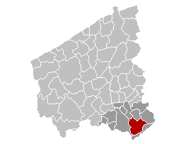
en: Map of the province West-Flanders, showing Zwevegem municipality in red, and Kortrijk arrondissement in dark
fr: Carte indiquant la localisation de la commune de Zwevegem (en rouge) dans la province de Flandre occidentale, avec l'arrondissement de Courtrai en gris foncé
nl: Kaart van de provincie West-Vlaanderen met de gemeente Zwevegem in het rood en het arrondissement Kortrijk in het donkergrijs.
Licensing
[edit]
| I, the copyright holder of this work, release this work into the public domain. This applies worldwide. In some countries this may not be legally possible; if so: I grant anyone the right to use this work for any purpose, without any conditions, unless such conditions are required by law. |
File history
Click on a date/time to view the file as it appeared at that time.
| Date/Time | Thumbnail | Dimensions | User | Comment | |
|---|---|---|---|---|---|
| current | 18:25, 11 January 2006 | | 270 × 203 (5 KB) | Wester (talk | contribs) |
You cannot overwrite this file.
File usage on Commons
There are no pages that use this file.