File:Zungweni mountain skirmishes.png
Jump to navigation
Jump to search

Size of this preview: 691 × 600 pixels. Other resolutions: 277 × 240 pixels | 553 × 480 pixels | 710 × 616 pixels.
Original file (710 × 616 pixels, file size: 1.1 MB, MIME type: image/png)
Captions
Captions
Add a one-line explanation of what this file represents
Summary
[edit]
| Description |
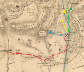
English: Military Map of Zulu Land, 1879 |
| Date | |
| Source |
This file was derived from: Military Map of Zulu Land.jpg: |
| Author |
|
| This is a retouched picture, which means that it has been digitally altered from its original version. Modifications: cropped and added movements related to Zungweni Mountain skirmishes, per pages 62-63 of (in English) (2003) Zulu War 1879: Twilight of a Warrior Nation, Oxford: Osprey Publishing ISBN: 1-85532-165-3. . The original can be viewed here: Military Map of Zulu Land.jpg:
|
Licensing
[edit]
|
This work is in the public domain in its country of origin and other countries and areas where the copyright term is the author's life plus 70 years or fewer. This work is in the public domain in the United States because it was published (or registered with the U.S. Copyright Office) before January 1, 1929. | |
| This file has been identified as being free of known restrictions under copyright law, including all related and neighboring rights. | |
Original upload log
[edit]
This image is a derivative work of the following images:
- File:Military Map of Zulu Land.jpg licensed with PD-old-70-expired
- 2019-12-03T19:56:53Z Hohum 2307x1700 (4701679 Bytes) User created page with UploadWizard
Uploaded with derivativeFX
File history
Click on a date/time to view the file as it appeared at that time.
| Date/Time | Thumbnail | Dimensions | User | Comment | |
|---|---|---|---|---|---|
| current | 08:32, 10 January 2022 | | 710 × 616 (1.1 MB) | Dumelow (talk | contribs) | Update position of Zungweni, closer to Nek |
| 08:13, 10 January 2022 |  | 710 × 616 (990 KB) | Dumelow (talk | contribs) | == {{int:filedesc}} == {{Information |Description={{en|1=Military Map of Zulu Land, 1879}} |date=1879-05-21 |Source={{Derived from|Military Map of Zulu Land.jpg|display=50}} |Date=2022-01-10 08:13 (UTC) |Author=* File:Military Map of Zulu Land.jpg: Intelligence Branch of the Quartermaster General’s Department of the British Army * derivative work: [[User:{{subst:REVISIONUSER}}|{{subst:REVISIONUSER}}]] |Permission= |other_versions= }} {{RetouchedPicture... |
You cannot overwrite this file.
File usage on Commons
There are no pages that use this file.
File usage on other wikis
The following other wikis use this file:
- Usage on en.wikipedia.org