File:Zugspitzregion Karte um 1770.jpg
Jump to navigation
Jump to search

Size of this preview: 658 × 600 pixels. Other resolutions: 263 × 240 pixels | 527 × 480 pixels | 843 × 768 pixels | 1,123 × 1,024 pixels | 2,247 × 2,048 pixels | 5,065 × 4,617 pixels.
Original file (5,065 × 4,617 pixels, file size: 6.99 MB, MIME type: image/jpeg)
Captions
Captions
Add a one-line explanation of what this file represents
Summary
[edit]
| Description |
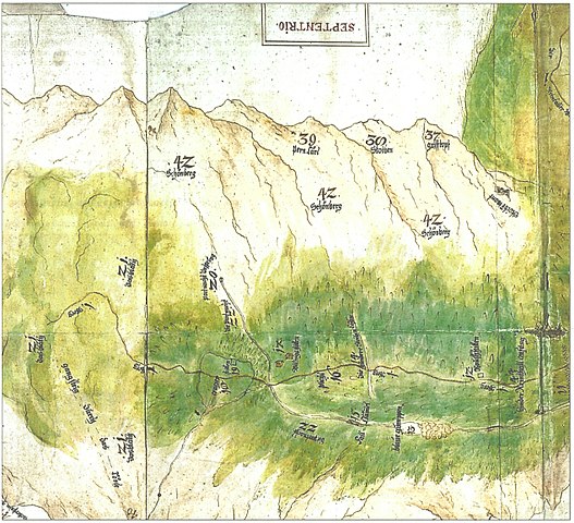
Deutsch: Ausschnitt einer historischen Karte der Zugspitzregion, gescannt mit 400 dpi aus Zeitung 213 mm hoch und 203 mm breit. Der Ausschnitt zeigt das hintere Reintal mit Blauer Gumpe und Partnachursprung und einen Teil vom Zugspitzplatt. Norden ist in der Karte oben. |
| Date | circa 1770 |
| Source | Bayerns Geschichte in Karten und Luftbild. In: Bayerische Staatszeitung, 4. Mai 2018, S. 22, darin: Historische Karte der Zugspitzregion um das Jahr 1770 |
| Author | Unknown |
Licensing
[edit]
|
This work is in the public domain in its country of origin and other countries and areas where the copyright term is the author's life plus 70 years or fewer. This work is in the public domain in the United States because it was published (or registered with the U.S. Copyright Office) before January 1, 1929. | |
| This file has been identified as being free of known restrictions under copyright law, including all related and neighboring rights. | |
File history
Click on a date/time to view the file as it appeared at that time.
| Date/Time | Thumbnail | Dimensions | User | Comment | |
|---|---|---|---|---|---|
| current | 09:15, 8 May 2018 | | 5,065 × 4,617 (6.99 MB) | Ratzer (talk | contribs) | User created page with UploadWizard |
You cannot overwrite this file.
File usage on Commons
The following page uses this file:
File usage on other wikis
The following other wikis use this file:
- Usage on de.wikipedia.org