File:Zia Formation badlands.jpg
Jump to navigation
Jump to search

Size of this preview: 800 × 600 pixels. Other resolutions: 320 × 240 pixels | 640 × 480 pixels | 1,024 × 768 pixels | 1,280 × 960 pixels | 2,560 × 1,920 pixels | 4,000 × 3,000 pixels.
Original file (4,000 × 3,000 pixels, file size: 2.39 MB, MIME type: image/jpeg)
Captions
Captions
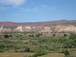
Zia Formation badlands northwest of Jemez Pueblo, New Mexico, USA
Summary
[edit]
| Description |
English: This image shows badlands eroded out of the Zia Formation northwest of Jemez Pueblo, New Mexico, USA. The Zia Formation is a Miocene formation deposited as early rift fill sediments of the Rio Grande rift. The soft white sandstone beds of the formation are capped by more resistant calicified river gravels of the ancestral Jemez River. On the skyline behind the badlands is Mesa Chuchilla, underlain by Permian and Triassic red bed formations. |
| Date | |
| Source | Own work |
| Author | Kent G. Budge |
| Camera location | | View this and other nearby images on: OpenStreetMap |
|---|
Licensing
[edit]
I, the copyright holder of this work, hereby publish it under the following license:
| This file is made available under the Creative Commons CC0 1.0 Universal Public Domain Dedication. | |
| The person who associated a work with this deed has dedicated the work to the public domain by waiving all of their rights to the work worldwide under copyright law, including all related and neighboring rights, to the extent allowed by law. You can copy, modify, distribute and perform the work, even for commercial purposes, all without asking permission.
|
File history
Click on a date/time to view the file as it appeared at that time.
| Date/Time | Thumbnail | Dimensions | User | Comment | |
|---|---|---|---|---|---|
| current | 16:33, 20 July 2020 | | 4,000 × 3,000 (2.39 MB) | Kent G. Budge (talk | contribs) | Uploaded own work with UploadWizard |
You cannot overwrite this file.
File usage on Commons
There are no pages that use this file.
File usage on other wikis
The following other wikis use this file:
- Usage on en.wikipedia.org