File:Zastupitelské úřady Abcházie.svg
Jump to navigation
Jump to search

Size of this PNG preview of this SVG file: 800 × 353 pixels. Other resolutions: 320 × 141 pixels | 640 × 283 pixels | 1,024 × 452 pixels | 1,280 × 565 pixels | 2,560 × 1,130 pixels | 940 × 415 pixels.
Original file (SVG file, nominally 940 × 415 pixels, file size: 1.42 MB)
Captions
Captions
Add a one-line explanation of what this file represents
Summary
[edit]
| Description |
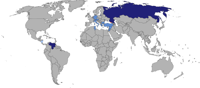
English: Map of diplomatic missions of Abkhazia
Abkhazia
Abkhaz embassy
Abkhaz representative office
Abkhaz embassy, non-resident
Čeština: Mapa abchazských zastupitelských úřadů
Abcházie
abchazské velvyslanectví
abchazská mise
abchazské nerezidentní velvyslanectví |
| Date | 1.8.2011 |
| Source |
This file was derived from: BlankMap-World6, compact.svg |
| Author | Jan CZ |
Licensing
[edit]
| This map is ineligible for copyright and therefore in the public domain, because it consists entirely of information that is common property and contains no original authorship. For more information, see Commons:Threshold of originality § Maps.
|
File history
Click on a date/time to view the file as it appeared at that time.
| Date/Time | Thumbnail | Dimensions | User | Comment | |
|---|---|---|---|---|---|
| current | 10:29, 29 June 2024 | | 940 × 415 (1.42 MB) | Kashmiri (talk | contribs) | Reverted to version as of 12:03, 26 November 2017 (UTC) |
| 11:48, 1 October 2023 |  | 940 × 415 (1.43 MB) | Caawiyahaderon (talk | contribs) | https://www.thehindu.com/news/international/pro-somalia-militia-takes-key-army-base-in-breakaway-region/article67238670.ece | |
| 12:03, 26 November 2017 |  | 940 × 415 (1.42 MB) | Jan CZ (talk | contribs) | add Israel | |
| 21:41, 4 April 2016 |  | 940 × 415 (1.42 MB) | Jan CZ (talk | contribs) | update of countries | |
| 21:26, 4 April 2016 |  | 940 × 415 (1.42 MB) | Jan CZ (talk | contribs) | standard colors | |
| 21:54, 12 January 2012 |  | 940 × 415 (1.68 MB) | Jan CZ (talk | contribs) | změna úřadu Vanuatu→Fidži odstranění honorárních konzulátů | |
| 13:57, 1 August 2011 |  | 940 × 415 (1.68 MB) | Jan CZ (talk | contribs) | {{Information |Description ={{en|1=Map of Abkhazian missions}} {{cs|1=mapa abchazských zastupitelských úřadů}} |Source =vlastní dílo |Author =Jan CZ |Date =1.8.2011 |Permission = |other_versions = }} {{legend|#FF0 |
You cannot overwrite this file.
File usage on Commons
The following page uses this file:
File usage on other wikis
The following other wikis use this file:
- Usage on bn.wikipedia.org
- Usage on cs.wikipedia.org
- Usage on de.wikipedia.org
- Usage on en.wikipedia.org
- Usage on es.wikipedia.org
- Usage on fa.wikipedia.org
- Usage on fr.wikipedia.org
- Usage on zh.wikipedia.org