File:Zapotec languages map.svg
Jump to navigation
Jump to search

Size of this PNG preview of this SVG file: 512 × 337 pixels. Other resolutions: 320 × 211 pixels | 640 × 421 pixels | 1,024 × 674 pixels | 1,280 × 843 pixels | 2,560 × 1,685 pixels.
Original file (SVG file, nominally 512 × 337 pixels, file size: 762 KB)
Captions
Captions
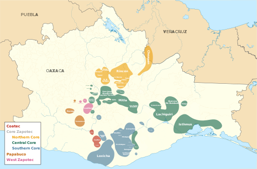
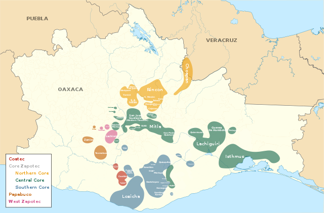
Current distribution of Zapotec languages in Oaxaca and Veracruz (classification based on Glottolog)
Summary
[edit]
| Description |
English: Distribution: adapted from Ethnologue maps (I usually like to cross reference 3 or more sources but honestly could not find any other detailed (academic or non academic) maps.
Classification: Glottolog (Solteco Zapotec is not included in the legend as it is extinct) This file was derived from: Mexico Oaxaca Salina Cruz location map.svg |
| Date | |
| Source | Own work |
| Author | Noahedits |
Licensing
[edit]
I, the copyright holder of this work, hereby publish it under the following license:
This file is licensed under the Creative Commons Attribution-Share Alike 4.0 International license.
- You are free:
- to share – to copy, distribute and transmit the work
- to remix – to adapt the work
- Under the following conditions:
- attribution – You must give appropriate credit, provide a link to the license, and indicate if changes were made. You may do so in any reasonable manner, but not in any way that suggests the licensor endorses you or your use.
- share alike – If you remix, transform, or build upon the material, you must distribute your contributions under the same or compatible license as the original.
File history
Click on a date/time to view the file as it appeared at that time.
| Date/Time | Thumbnail | Dimensions | User | Comment | |
|---|---|---|---|---|---|
| current | 18:12, 19 January 2020 | | 512 × 337 (762 KB) | Noahedits (talk | contribs) | Moving some text leftwards |
| 18:07, 19 January 2020 |  | 512 × 337 (762 KB) | Noahedits (talk | contribs) | Trying export settings again | |
| 07:58, 19 January 2020 |  | 512 × 337 (828 KB) | Noahedits (talk | contribs) | Changed font to Lato (should fix rendering of type?) | |
| 07:34, 19 January 2020 |  | 512 × 337 (829 KB) | Noahedits (talk | contribs) | Changed export settings (for hopefully better rendering of text) | |
| 07:32, 19 January 2020 |  | 512 × 337 (814 KB) | Noahedits (talk | contribs) | User created page with UploadWizard |
You cannot overwrite this file.
File usage on Commons
There are no pages that use this file.
File usage on other wikis
The following other wikis use this file:
- Usage on en.wikipedia.org
- Usage on simple.wikipedia.org
- Usage on vi.wikipedia.org