File:Zamosc-Karte.jpg

From Wikimedia Commons, the free media repository
Jump to navigation Jump to search

Original file(3,731 × 2,780 pixels, file size: 4.77 MB, MIME type: image/jpeg)

Captions

Captions

Add a one-line explanation of what this file represents

Summary

[edit]
Description
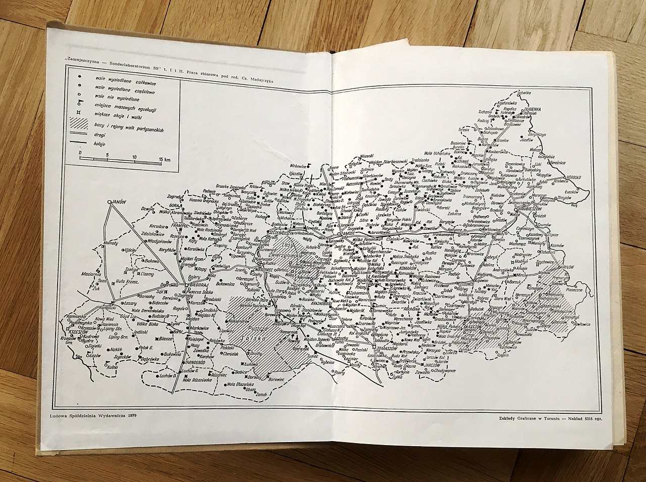
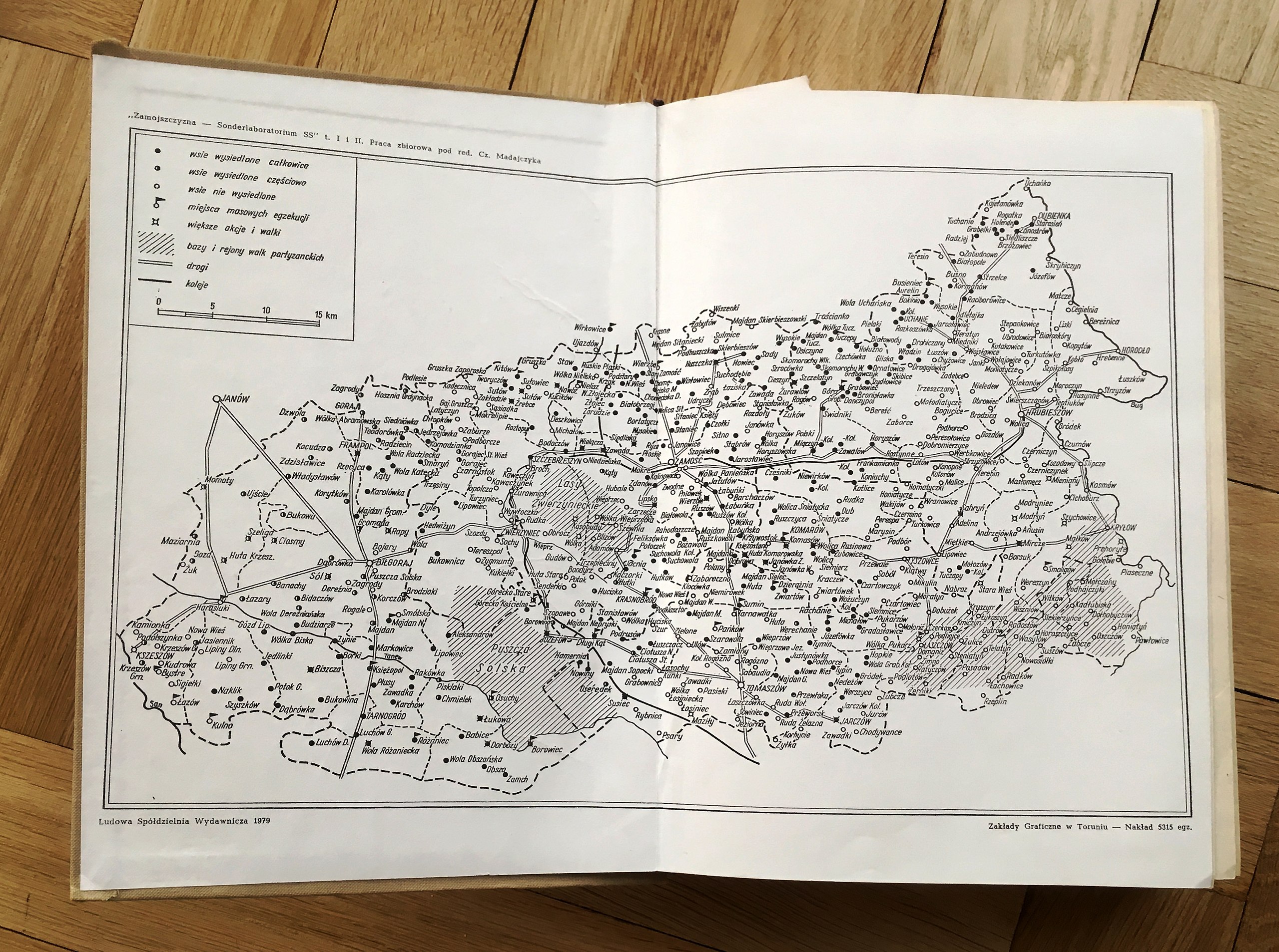
English: Map of the region Zamosc, on which all destroyed or resettled villages are marked.
Deutsch: Karte der Region Zamosc, auf der alle zerstörten, bzw. ausgesiedelten Dörfer gekennzeichnet sind.
Date 1979, Warszawa
Source
Files from the CIRCE-Archiv as uploaded by Commons user Kajo2019 are released under the Creative Commons Attribution ShareAlike 3.0 Germany licence."
w:en:Creative Commons
attribution share alike
This file is licensed under the Creative Commons Attribution-Share Alike 3.0 Germany license.
You are free:
  • to share – to copy, distribute and transmit the work
  • to remix – to adapt the work
Under the following conditions:
  • attribution – You must give appropriate credit, provide a link to the license, and indicate if changes were made. You may do so in any reasonable manner, but not in any way that suggests the licensor endorses you or your use.
  • share alike – If you remix, transform, or build upon the material, you must distribute your contributions under the same or compatible license as the original.
VRT Wikimedia

This work is free and may be used by anyone for any purpose. If you wish to use this content, you do not need to request permission as long as you follow any licensing requirements mentioned on this page.

The Wikimedia Foundation has received an e-mail confirming that the copyright holder has approved publication under the terms mentioned on this page. This correspondence has been reviewed by a Volunteer Response Team (VRT) member and stored in our permission archive. The correspondence is available to trusted volunteers as ticket #2019101410002561.

If you have questions about the archived correspondence, please use the VRT noticeboard. Ticket link: https://ticket.wikimedia.org/otrs/index.pl?Action=AgentTicketZoom&TicketNumber=2019101410002561
Find other files from the same ticket: SDC query (SPARQL)

Author Dokumetensammlung Zamojszczyzna Sonderlaboratorium SS, Ludowa Spoldzielnia Wydawnica
Permission
(Reusing this file)
Files from the CIRCE-Archiv as uploaded by Commons user Kajo2019 are released under the Creative Commons Attribution ShareAlike 3.0 Germany licence."
w:en:Creative Commons
attribution share alike
This file is licensed under the Creative Commons Attribution-Share Alike 3.0 Germany license.
You are free:
  • to share – to copy, distribute and transmit the work
  • to remix – to adapt the work
Under the following conditions:
  • attribution – You must give appropriate credit, provide a link to the license, and indicate if changes were made. You may do so in any reasonable manner, but not in any way that suggests the licensor endorses you or your use.
  • share alike – If you remix, transform, or build upon the material, you must distribute your contributions under the same or compatible license as the original.
VRT Wikimedia

This work is free and may be used by anyone for any purpose. If you wish to use this content, you do not need to request permission as long as you follow any licensing requirements mentioned on this page.

The Wikimedia Foundation has received an e-mail confirming that the copyright holder has approved publication under the terms mentioned on this page. This correspondence has been reviewed by a Volunteer Response Team (VRT) member and stored in our permission archive. The correspondence is available to trusted volunteers as ticket #2019101410002561.

If you have questions about the archived correspondence, please use the VRT noticeboard. Ticket link: https://ticket.wikimedia.org/otrs/index.pl?Action=AgentTicketZoom&TicketNumber=2019101410002561
Find other files from the same ticket: SDC query (SPARQL)

Camera location50° 55′ 06.36″ N, 7° 14′ 08.96″ E  Heading=64.68246° Kartographer map based on OpenStreetMap.View this and other nearby images on: OpenStreetMapinfo

Licensing

[edit]
I, the copyright holder of this work, hereby publish it under the following license:
Creative Commons CC-Zero This file is made available under the Creative Commons CC0 1.0 Universal Public Domain Dedication.
The person who associated a work with this deed has dedicated the work to the public domain by waiving all of their rights to the work worldwide under copyright law, including all related and neighboring rights, to the extent allowed by law. You can copy, modify, distribute and perform the work, even for commercial purposes, all without asking permission.

File history

Click on a date/time to view the file as it appeared at that time.

Date/TimeThumbnailDimensionsUserComment
current08:51, 16 November 2019Thumbnail for version as of 08:51, 16 November 20193,731 × 2,780 (4.77 MB)Kajo2019 (talk | contribs){{Information |description ={{en|1=Map of the region Zamosc, on which all destroyed or resettled villages are marked.}} {{de|1=Karte der Region Zamosc, auf der alle zerstörten, bzw. ausgesiedelten Dörfer gekennzeichnet sind.}} |date =1979, Warszawa |source = {{Template:CIRCE-Archiv-permission}} |author =Dokumetensammlung Zamojszczyzna Sonderlaboratorium SS, Ludowa Spoldzielnia Wydawnica |permission ={{Template:CIRCE-Archiv-permission}} }} [[Category:Custom CC li...

There are no pages that use this file.

Metadata