File:Zaglebiowska Masa Krytyczna Sosnowiec.jpg
Jump to navigation
Jump to search

Size of this preview: 800 × 548 pixels. Other resolutions: 320 × 219 pixels | 640 × 439 pixels | 1,024 × 702 pixels | 1,280 × 877 pixels | 2,560 × 1,755 pixels | 3,991 × 2,736 pixels.
Original file (3,991 × 2,736 pixels, file size: 2.38 MB, MIME type: image/jpeg)
Captions
Captions
Add a one-line explanation of what this file represents
Summary
[edit]
| Description |
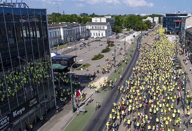
Polski: Centrum miasta Sosnowca; 5000 uczestników Zagłębiowskiej Masy Krytycznej tuż przed startem w Sosnowcu na ulicy 3 Maja; Plac przed dworcem kolejowym Sosnowiec Główny; Na pierwszym planie po lewej Sezam; Po prawej na dalszym planie zabudowania przy Placu Stulecia.
English: Sosnowiec city center; 5000 participants of Zagłębie Critical Mass just before the start in Sosnowiec on 3 Maja Street; Square in front of the Sosnowiec Główny railway station; In the foreground, on the left, Sesame; On the right, in the background, the buildings at Plac Stulecia.
Русский: Центр города Сосновец; 5000 участников Zagłębie Critical Mass перед самым стартом в Сосновце на улице 3 Maja; Площадь перед вокзалом Сосновец-Главный; На переднем плане слева - Кунжут; Справа на заднем плане здания на Plac Stulecia.
Español: Centro de la ciudad de Sosnowiec; 5000 participantes de Zagłębie Critical Mass justo antes de la salida en Sosnowiec en 3 Maja Street; Plaza frente a la estación de tren Sosnowiec Główny; En primer plano, a la izquierda, Sésamo; A la derecha, al fondo, los edificios de Plac Stulecia.
Українська: Центр міста Сосновець; 5000 учасників Zagłębie Critical Mass безпосередньо перед стартом у Сосновці на вулиці Майя, 3; площа перед залізничною станцією Сосновець Головний; На передньому плані, зліва, Кунжут; Праворуч, на задньому плані, будівлі Plac Stulecia. |
| Date | |
| Source | Own work |
| Author | Stimoroll |
| Openstreetmap entry | Link to Openstreetmap |
| Object location | | View this and other nearby images on: OpenStreetMap |
|---|
| Camera location | | View this and other nearby images on: OpenStreetMap |
|---|
Licensing
[edit]
I, the copyright holder of this work, hereby publish it under the following license:
This file is licensed under the Creative Commons Attribution-Share Alike 4.0 International license.
- You are free:
- to share – to copy, distribute and transmit the work
- to remix – to adapt the work
- Under the following conditions:
- attribution – You must give appropriate credit, provide a link to the license, and indicate if changes were made. You may do so in any reasonable manner, but not in any way that suggests the licensor endorses you or your use.
- share alike – If you remix, transform, or build upon the material, you must distribute your contributions under the same or compatible license as the original.
| Annotations | This image is annotated: View the annotations at Commons |
File history
Click on a date/time to view the file as it appeared at that time.
| Date/Time | Thumbnail | Dimensions | User | Comment | |
|---|---|---|---|---|---|
| current | 08:45, 7 May 2018 | | 3,991 × 2,736 (2.38 MB) | KrzysztofPoplawski (talk | contribs) | User created page with UploadWizard |
You cannot overwrite this file.
File usage on Commons
The following 2 pages use this file:
File usage on other wikis
The following other wikis use this file:
- Usage on it.wikipedia.org
- Usage on pl.wikipedia.org
- Usage on pl.wikinews.org
- Usage on pl.wiktionary.org
- Usage on www.wikidata.org