File:Zárt híd a Kisszeminárium és Jezsuita rendház között, 2019 Kalocsa.jpg

Original file (1,704 × 1,610 pixels, file size: 744 KB, MIME type: image/jpeg)
Captions
Captions
Summary
[edit]
| Description |
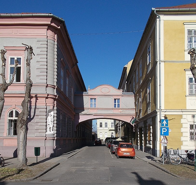
English: : Buit in 1879-1880 to Seminary (Little Seminary), in the site of the Inner City Parish Office and Church (both built in 1711). In 1907 the Jesuits take over and connected to the Jesuit monastery by skyway bridge 'The Bridge of Sighs' (built in 1908). Listed school building include City Art Gallery. Built in 1880 ordered by Archbishop Lajos Haynald (1867-1891), constructed by József Greif. - 12-14, Szent István király út, Kalocsa, Bács-Kiskun County.
Magyar: : Kisszeminárium sarok szoborfülkében Szt. Flórián Izsó Miklóst utánzó szobra . Építtette Haynald Lajos érsek 1877-1878-ban. Vezetését 1907-ben a jezsuiták vették át, az épületet a jezsuita rendházzal (trsz.: 572 ID 2211) összekötő, zárt híd 1908-ban épült. Azonosító: 2210 törzsszám: 571 - Bács-Kiskun megye, Kalocsa, Szent István király út (ex Szentháromság utca) 12-14. Batthyany József utca (ex Kistemplom köz). Hunyadi utca.
|
||||
| Date | |||||
| Source | Own work | ||||
| Author | Globetrotter19 |
| Object location | | View this and other nearby images on: OpenStreetMap |
|---|
| Camera location | | View this and other nearby images on: OpenStreetMap |
|---|
Licensing
[edit]
- You are free:
- to share – to copy, distribute and transmit the work
- to remix – to adapt the work
- Under the following conditions:
- attribution – You must give appropriate credit, provide a link to the license, and indicate if changes were made. You may do so in any reasonable manner, but not in any way that suggests the licensor endorses you or your use.
- share alike – If you remix, transform, or build upon the material, you must distribute your contributions under the same or compatible license as the original.
| Annotations | This image is annotated: View the annotations at Commons |
File history
Click on a date/time to view the file as it appeared at that time.
| Date/Time | Thumbnail | Dimensions | User | Comment | |
|---|---|---|---|---|---|
| current | 21:00, 13 March 2019 | | 1,704 × 1,610 (744 KB) | Globetrotter19 (talk | contribs) | User created page with UploadWizard |
You cannot overwrite this file.
File usage on Commons
There are no pages that use this file.
Metadata
This file contains additional information such as Exif metadata which may have been added by the digital camera, scanner, or software program used to create or digitize it. If the file has been modified from its original state, some details such as the timestamp may not fully reflect those of the original file. The timestamp is only as accurate as the clock in the camera, and it may be completely wrong.
| Exposure time | 1/250 sec (0.004) | ||||||||||||
|---|---|---|---|---|---|---|---|---|---|---|---|---|---|
| F-number | f/8.6 | ||||||||||||
| Lens focal length | 5.3 mm | ||||||||||||
| Short title |
| ||||||||||||
| Orientation | Normal | ||||||||||||
| Horizontal resolution | 300 dpi | ||||||||||||
| Vertical resolution | 300 dpi | ||||||||||||
| File change date and time | 19:42, 13 March 2019 | ||||||||||||
| Y and C positioning | Co-sited | ||||||||||||
| Meaning of each component |
| ||||||||||||
| Image compression mode | 2 | ||||||||||||
| APEX exposure bias | 0 | ||||||||||||
| Maximum land aperture | 3.4 APEX (f/3.25) | ||||||||||||
| Supported Flashpix version | 1 | ||||||||||||
| Color space | sRGB | ||||||||||||
| File source | Digital still camera | ||||||||||||
| Scene type | A directly photographed image | ||||||||||||
| Custom image processing | Normal process | ||||||||||||
| Exposure mode | Auto exposure | ||||||||||||
| Digital zoom ratio | 0 | ||||||||||||
| Scene capture type | Landscape | ||||||||||||
| Scene control | Low gain up | ||||||||||||
| Subject distance range | Unknown |