File:Yungay avalanche labels.jpg
Jump to navigation
Jump to search

Size of this preview: 401 × 600 pixels. Other resolutions: 160 × 240 pixels | 321 × 480 pixels.
Original file (800 × 1,197 pixels, file size: 1.1 MB, MIME type: image/jpeg)
Captions
Captions
Add a one-line explanation of what this file represents
Summary
[edit]
| Description |
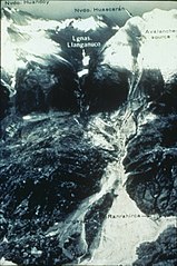
English: Aerial view of the 1970 Huascarán avalanche that destroyed Yungay, Peru.
Español: Vista aérea de la avalancha del Huascarán de 1970 que destruyó Yungay, Perú. |
| Date | circa 1970 |
| Source | https://www.ngdc.noaa.gov/hazardimages/picture/show/785#data |
| Author | NOAA/NGDC, G. Pflafker, U.S. Geological Survey. |
Licensing
[edit]
This image is in the public domain because it contains materials that originally came from the U.S. National Oceanic and Atmospheric Administration, taken or made as part of an employee's official duties.
|
File history
Click on a date/time to view the file as it appeared at that time.
| Date/Time | Thumbnail | Dimensions | User | Comment | |
|---|---|---|---|---|---|
| current | 19:10, 7 February 2018 | | 800 × 1,197 (1.1 MB) | Shannon1 (talk | contribs) | {{Information |Description ={{en|1=Aerial view of the 1970 Huascarán avalanche that destroyed Yungay, Peru. }} |Source =https://www.ngdc.noaa.gov/hazardimages/picture/show/785#data |Author =NOAA/NGDC, G. Pflafker, U.S. Geological Su... |
You cannot overwrite this file.
File usage on Commons
The following page uses this file:
File usage on other wikis
The following other wikis use this file:
- Usage on arz.wikipedia.org
- Usage on de.wikipedia.org
- Usage on en.wikipedia.org
- Usage on es.wikipedia.org
- Usage on id.wikipedia.org
- Usage on it.wikipedia.org
- Usage on ja.wikipedia.org
- Usage on pt.wikipedia.org
- Usage on vec.wikipedia.org
- Usage on www.wikidata.org